midatlanticweather
-
Posts
4,576 -
Joined
-
Last visited
Content Type
Profiles
Blogs
Forums
American Weather
Media Demo
Store
Gallery
Everything posted by midatlanticweather
-
And the d thing that cannot be named.
-
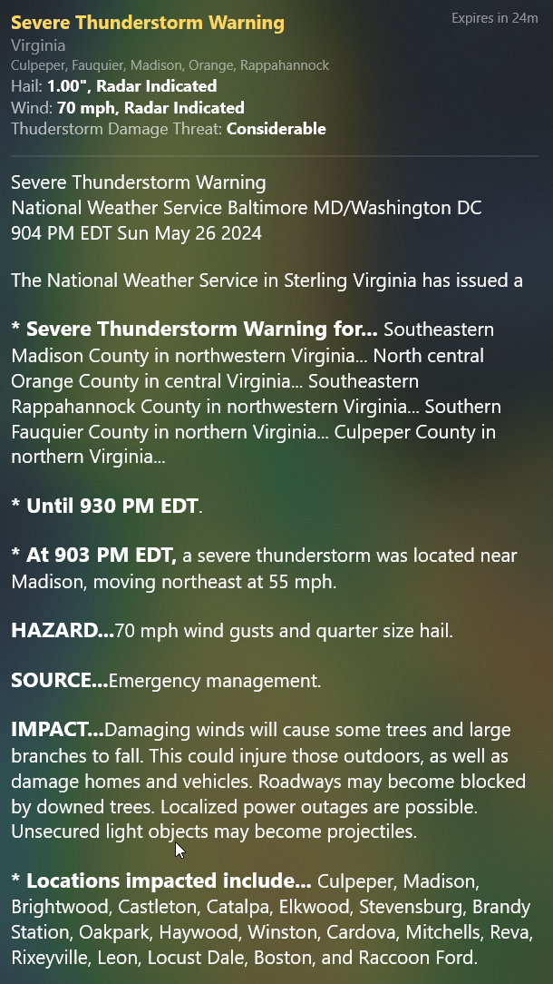
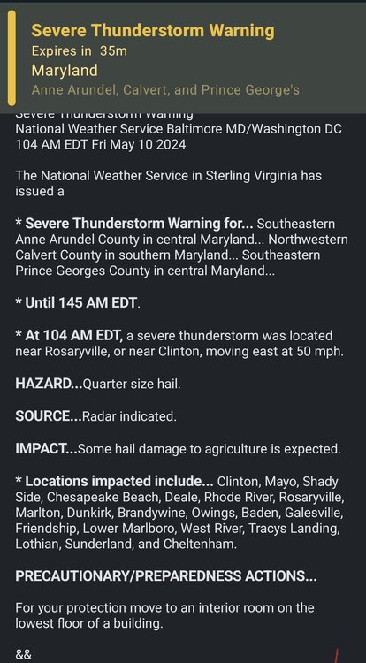
In all the excitement yesterday, I am not certain this was shared. If so, I can delete. 922 NOUS41 KLWX 272245 PNSLWX DCZ001-MDZ001-003>006-008-011-013-014-016>018-501>508-VAZ025>031- 036>040-050-051-053>057-501>508-526-527-WVZ050>053-055-501>506- 281045- Public Information Statement National Weather Service Baltimore MD/Washington DC 645 PM EDT Mon May 27 2024 ...NWS Damage Survey for 5/26/24 Rixeyville Virginia Tornado... .Rixeyville Tornado... Rating: EF-1 Estimated Peak Wind: 95 mph Path Length /statute/: 4.8 miles Path Width /maximum/: 100 yards Fatalities: 0 Injuries: 5 Start Date: 05/26/2024 Start Time: 09:27 PM EDT Start Location: 5 WSW Rixeyville / Culpeper County / VA Start Lat/Lon: 38.5593 / -78.0636 End Date: 05/26/2024 End Time: 09:35 PM EDT End Location: Rixeyville / Culpeper County / VA End Lat/Lon: 38.5807 / -77.9800 Survey Summary: The National Weather Service conducted a ground survey of storm damage in the Rixeyville area that occurred on Sunday night,May 26, 2024. NWS Doppler Weather Radar in Sterling, Virginia showed a rotating severe thunderstorm that developed a tornado. The National Weather Service issued a Tornado Warning for the affected area at 9:15 PM EDT, in advance of the tornado. Radar also showed a tornado damage signature due to lofted debris from the tornado as it was occurring. The tornado touched down along Dunkard Church Road, a third of a mile west of Eggbornsville Road in rural, northwest Culpeper County. Several trees were snapped and uprooted in multiple directions. The tornado proceeded east- northeast and crossed Eggbornsville Road. In this area two dozen trees were noted to be snapped and uprooted in multiple directions. The tornado passed over several homes and a church, but no structural damage was noted to these. The winds picked up and overturned a large shed with five occupants; these people were injured when the shed overturned due to the strong winds. Another smaller shed was also overturned. A resident reported seeing the funnel touch down to the west of the road. Another resident reported receiving the Tornado Warning in advance over the cell phone Wireless Emergency Alerts. A drone video showed a path of damage that was approximately 100 yards wide. The tornado continued east-northeast, snapping and uprooting at least a dozen large trees along Settle School Road as it traversed a stretch of that road between Tolivers Forest Lane and Spring Hollow Lane. Several trees were snapped down as it crossed Dutch Hollow Road. Tree damage continued to be in multiple directions, including opposite the storm motion. The tornado proceeded another two miles, but did not cross another road until the final property where damage was noted. In the 9000 block of Monumental Mills Road, a two foot diameter branch of a large beech tree was snapped off, along with smaller tree damage from a southeast wind. That was the last damage noted, and there was no damage seen just east along Rixeyville Road. The National Weather Service would like to thank Culpeper County Department of Emergency Services for their support in conducting this survey, and providing storm damage reports to the National Weather Service the night of the tornado. && EF Scale: The Enhanced Fujita Scale classifies tornadoes into the following categories: EF0.....65 to 85 mph EF1.....86 to 110 mph EF2.....111 to 135 mph EF3.....136 to 165 mph EF4.....166 to 200 mph EF5.....>200 mph NOTE: The information in this statement is preliminary and subject to change pending final review of the event and publication in NWS Storm Data. $$
- 1,696 replies
-
- 4
-

-

-
- severe
- thunderstorms
- (and 5 more)
-
Near great falls. Interesting
-
The cell near The Plains and west of Haymarket has my attention
-
Mesoscale Discussion 1021 NWS Storm Prediction Center Norman OK 0349 PM CDT Mon May 27 2024 Areas affected...portions of eastern North Carolina and eastern Virginia Concerning...Tornado Watch 335... Valid 272049Z - 272215Z The severe weather threat for Tornado Watch 335 continues. SUMMARY...The severe threat continues across Tornado Watch 335. Large hail and damaging gusts remain a concern. The best chance for tornadoes would be closer to the coastline ahead of ongoing storms. DISCUSSION...Multicells and transient supercells persist across northeastern NC and are moving northeast toward southeast VA. At the moment, these are the most robust storms across eastern NC/VA, though an increase in thunderstorm coverage is possible later this afternoon. Given widespread 1000-3000 J/kg MLCAPE and 40+ kts of effective bulk shear, most thunderstorms should maintain a multicellular or transient supercell mode through the afternoon. While a tornado or two cannot be ruled out anywhere across Tornado Watch 335 in eastern NC/VA, the best chance for tornadoes appears to be far southeast VA/northeast NC closer to the coast, where backed low-level winds are contributing to slightly larger low-level hodographs.
- 1,696 replies
-
- 1
-
-
- severe
- thunderstorms
- (and 5 more)
-
-
Others called out that there was a brief debris ball on CC. I dunno! we will see.
-
CC was interesting for a moment, but I think that was a false signal.
- 1,696 replies
-
- 1
-
-
- severe
- thunderstorms
- (and 5 more)
-
A huge polygon for the entire line is now issued. BULLETIN - IMMEDIATE BROADCAST REQUESTED Severe Thunderstorm Warning National Weather Service Baltimore MD/Washington DC 905 PM EDT Sun May 26 2024 The National Weather Service in Sterling Virginia has issued a * Severe Thunderstorm Warning for... Northwestern Washington County in north central Maryland... Northeastern Allegany County in western Maryland... Southwestern Stafford County in northern Virginia... Southwestern Loudoun County in northern Virginia... Northeastern Shenandoah County in northwestern Virginia... Frederick County in northwestern Virginia... Orange County in central Virginia... The City of Fredericksburg in central Virginia... Rappahannock County in northwestern Virginia... Central Fauquier County in northern Virginia... Culpeper County in northern Virginia... Central Madison County in northwestern Virginia... Warren County in northwestern Virginia... Western Clarke County in northwestern Virginia... Northeastern Page County in northwestern Virginia... The City of Winchester in northwestern Virginia... Spotsylvania County in central Virginia... West central Jefferson County in the Panhandle of West Virginia... Morgan County in the Panhandle of West Virginia... Northeastern Mineral County in eastern West Virginia... Northeastern Hardy County in eastern West Virginia... Western Berkeley County in the Panhandle of West Virginia... Hampshire County in eastern West Virginia... * Until 1000 PM EDT. * At 905 PM EDT, severe thunderstorms were located along a line extending from near La Vale to 6 miles south of Romney to 6 miles north of Basye-Bryce Mountain to near Mount Jackson to 6 miles north of Boswells Tavern, moving east at 35 mph. HAZARD...60 mph wind gusts. SOURCE...Radar indicated. IMPACT...Damaging winds will cause some trees and large branches to fall. This could injure those outdoors, as well as damage homes and vehicles. Roadways may become blocked by downed trees. Localized power outages are possible. Unsecured light objects may become projectiles. * Locations impacted include... Winchester, Fredericksburg, Cumberland, Culpeper, Front Royal, Warrenton, Strasburg, Woodstock, Orange, Hancock, Paw Paw, Madison, Millwood Pike, Luray, Bealeton, Inwood, Stephens City, Fort Ashby, Berkeley Springs, and Sperryville. PRECAUTIONARY/PREPAREDNESS ACTIONS... For your protection move to an interior room on the lowest floor of a building.
-
Considerable just issued!

-
- 1,696 replies
-
- 1
-
-
- severe
- thunderstorms
- (and 5 more)
-
Crazy warning polygon

-
Watch is up

-
Severe close by
- 1,696 replies
-
- 1
-
-
- severe
- thunderstorms
- (and 5 more)
-
So we were downgraded to Marginal risk. Seems right based on all the trends.
-
89 here in Purcellville for the high today. Stinking hot!
-

April Medium/ Long Range Discussion
midatlanticweather replied to Weather Will's topic in Mid Atlantic
-
- 1,696 replies
-
- 1
-
-
- severe
- thunderstorms
- (and 5 more)
-
Nadocast https://x.com/nadocast/status/1778082581541752878
- 1,696 replies
-
- 2
-
-
- severe
- thunderstorms
- (and 5 more)
-
Lots of graupel/snow here in Purcellville. Temp dropped to 38!
-
66 degrees!! It was almost 70 an hour ago. Low was 61! Hot for this time of year!
-
Late Feb/March Medium/Long Range Discussion
midatlanticweather replied to WinterWxLuvr's topic in Mid Atlantic
Good news is that the European computing power was increased and now runs at least an hour sooner -
Late Feb/March Medium/Long Range Discussion
midatlanticweather replied to WinterWxLuvr's topic in Mid Atlantic