midatlanticweather
-
Posts
4,907 -
Joined
-
Last visited
1 Follower

About midatlanticweather

-
38.4 degrees for the low. No Frost but pretty cold
-
86.5 today was quite hot honestly. Not humid though. Watching the storms/rain progress slowly south.
-
 Sleet and snow now in Purcellville. Mainly sleet Shall move to Discobs since it is not severe related from now on
- 1,093 replies
-
- 1
-

-
- severe
- thunderstorms
- (and 1 more)
-
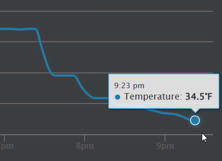
Down to 36 here in Purcellville. Windy and rainy
-
24.4 for a low. 25.5 currently
-
80 Degrees to Ripping Snow: March 12th
midatlanticweather replied to SnowenOutThere's topic in Mid Atlantic
Snow now and down to 36. -
80 Degrees to Ripping Snow: March 12th
midatlanticweather replied to SnowenOutThere's topic in Mid Atlantic
Basically, had a heavy shower that made things go to all sleet and even some slush balls, but as soon as it got lighter it went back to rain with some sleet and now just light rain with an occasional pinger. So, type of precip seems rate dependent which makes sense. Close to 38..was a bit cooler in the heavy precipitation -
80 Degrees to Ripping Snow: March 12th
midatlanticweather replied to SnowenOutThere's topic in Mid Atlantic
Rain mixing snow and sleet. 38.1 -
80 Degrees to Ripping Snow: March 12th
midatlanticweather replied to SnowenOutThere's topic in Mid Atlantic
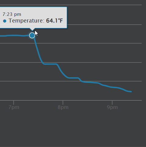
41.9 here in Purcellville. Temp dropped 2 degrees the last 20 mins. It was 72 around 4am. Pretty dramatic changes -
80 Degrees to Ripping Snow: March 12th
midatlanticweather replied to SnowenOutThere's topic in Mid Atlantic
You must record it and share -
2026 Mid-Atlantic Severe Storm General Discussion
midatlanticweather replied to Kmlwx's topic in Mid Atlantic

-
2026 Mid-Atlantic Severe Storm General Discussion
midatlanticweather replied to Kmlwx's topic in Mid Atlantic
Spidy sense on that storm north of Luray. -
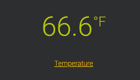
84.7 for a high. That is crazy. Ac was tested today