Albedoman
-
Posts
1,118 -
Joined
-
Last visited
Content Type
Profiles
Blogs
Forums
American Weather
Media Demo
Store
Gallery
Everything posted by Albedoman
-
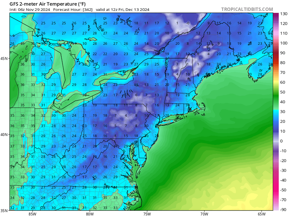
well Red Sky, you will have your white Christmas like I had promised. The big snow event was last night and not on Christmas eve/day . As I said my earlier posts days ago, if their was a decent snow pack, we would have below zero overnight lows. Well Monday morning wil be a dandy with temp below zero at my house and for many in the LV. I expect a 1-2 inch refresh of the snow pack on Christmas Eve and then it is off to big time moderation with lots of rain maybe an ice storm. This MAJOR pattern change coming up may lead to some decent snow events in mid january
-
3-4 inches in Macungie right now. still snowing
-
2 to 3 in on deck still puking snow
-
bullseye for me but this does not make sense . A norlun trough does not set up like this but I will take the outcome
-
I will take anything at this point. A 1-3 inch snow event would be a huge win in this crappy season thus far and overnight raditional cooling with a snow cover on Sat morning would push the lows in the single digits for sure over the weekend.
-
Well it now appears Christmas day will be brown. NO major snow event anywhere on the models for our area for and after Christmas and in fact after Christmas we get torched. Rain I will take but this crap of having freeze your balls off temps with no snow pack is utterly ridiculous. So many years of this stupid weather pattern is got to end soon. The snow producing storm events never matches up with the deep cold anymore as the deep cold air sticks around only for a few days . We are always on the frozen/liqid precip line too as a result. If we would have had a decent snowpack this weekend, we would have been below zero for overnight lows. I aslo do not know which is worse, the snow drought or rain drought? LOL I am sorry but with my 50+ years of weather history experience, I am realizing that the only way to break this shitty snow producing weather pattern will be a severe ice storm with a real deep and strong cold snap from repeated passing clippers every 2-3 days- kinda like 94. LOL.
-
dusting on the deck now- give me a break- no drought buster. The burn ban is lifted now in Lehigh county. Time for a fire with my new fire ring on Tuesday evening. Been waiting a long time almost 3 months. 55 degree high and sunny on Tuesday afternoon. Time to burn the fallen limbs. Last true day of fall before "WINTER IS COMING"

-
too much missing buoy data in the west PAC. Drones on the NJ coast hogging it all LMAO
-
MIne was right at 2" Flurries at the end more today. ...Lehigh County... 1 NE Lynn Twp 2.55 in 1005 PM 12/11 AWS Germansville 2.04 in 1010 PM 12/11 CWOP Slatington 2.03 in 1007 PM 12/11 CWOP New Tripoli 1.97 in 1000 PM 12/11 CWOP Center Valley 1.94 in 1008 PM 12/11 CWOP NEW TRIPOLI 1.91 in 1009 PM 12/11 CWOP Slatington 1.86 in 0930 PM 12/11 HADS Trexler 1.84 in 0943 PM 12/11 RAWS Fogelsville 1.81 in 1000 PM 12/11 CWOP
-
MY update: No drought buster. However it is the heaviest rain since early August for my house in a 24 hour period. Nearly 1.80 inches in the gauge and still raining. Underground weather precip reports mostly range from. 1.5 to 2 inches of rain in Lehigh County with more north near Tamaqua. Its nice to see the Little Lehigh at bankfull for a change. No stream flooding as the ground is taking it all in nicely. I expect this to be all out of here by midnight. There will some big wet snow flakes at the very end of the precip with maybe a coating on the cars. I expect this to happen between 10 pm and midnight Temps are dropping pretty good now high 64 this morning. Now it is 45 and falling Still fishing for a white Christmas - not goiving up just yet
- 1,105 replies
-
- 3
-

-

-
- tropics
- heavy rainfall
- (and 5 more)
-
white christmas on the 18Z hope is still alive
-
its going to be close thats for sure. This needs to be watched, maybe the 26th. Anyway, much needed rain by wed- thursday 2-3 in of rain by the latest runs with the possibility of anafront snowfall of 1-3 inches changeover as the really cold air quickly advects in behind the cold front. This would be nice because the snow that sticks to the ground after the rain will not melt for days. This situation will really help with soil moisture before the ground freezes shut by next weekend.
- 1,105 replies
-
- 1
-

-
- tropics
- heavy rainfall
- (and 5 more)
-
call it whatever the hell you want for the ENSO, but if we do not get substantial rains in the next 3-4 weeks we are in some deep shite. When I say susbsantial, I mean 3-6 inches spread out in a course of 2-3 weeks. The ground is frozen now in some places, Pure runoff does not help as the only benefit would be to hold off the salt water intrusion into the Delaware a few weeks longer. We need the ground to warm up, which we will get in the next few days but the 12th storm event is an absolute joke as a precip maker right now in the models. Sorry but .5 in rains for a few days will not cut it for some droughgt relief unless we became Seattle again, which I do not see with this progressive upper air flow at all My Christmas storm is slowly going away to the dumpster fire after every model run. WE cannot even squeeze out a good rainmaker of a noreaster. All I can say is that we are not the only ones being screwed in this crappy weather pattern. The Midwest, specially north of the Mason Dixon line is way too warm and dry. Without a good snowpack there, were are really screwed here. Any clipper that reaches here will be DOA without moisture. Flurries and snow shower will not cut it. The winners for snow- Great Lakes. Just when their feet of snow melts next week, they get another round. Will the lakes ever freeze up again in my lifetime LMAO? That pece of siberian high that has remained in Russa for the last 3 years needs to get its ass parked right over southern Cannada for 15 days.
- 1,105 replies
-
- 1
-
-
- tropics
- heavy rainfall
- (and 5 more)
-
This drought is rapidly becoming pretty damn serious folks Water supply managers for the Delaware River Basin this week declared an “emergency,” setting the stage for further action if dry conditions persist. The Delaware River Basin Commission declared the “water supply emergency” during its quarterly meeting Thursday. The declaration along with two special permits that were also approved allow the commission to coordinate operations of regional reservoirs, diversion from outside the 42-county basin area and Delaware River flow objectives. The last time commission officials declared such an emergency was in 2016, spokeswoman Elizabeth Brown told lehighvalleylive.com. “We’re essentially getting the table set if conditions continue to deteriorate,” she said. Despite recent precipitation, the potential is still there to reach basin-wide drought operating conditions that would trigger the action authorized Thursday. All but two of the counties in the basin covering communities in Delaware, New Jersey, New York and Pennsylvania are under drought watches or warnings declared independently of Thursday’s approvals. Those two counties are Lackawanna and Wayne in Pennsylvania. “DRBC urges all water users to fully cooperate with Basin state water use restrictions and conservation measures and encourages all Basin water users to maximize water efficiency wherever possible,” the commission said in a news release following Thursday’s approvals. A basin-wide drought declaration would occur if available water storage drops below a certain level in three New York City reservoirs — Cannonsville, Pepacton and Neversink — located in the Delaware River’s headwaters in New York. As of Thursday morning, storage was 25.9 billion gallons above a drought watch. “Over 14 million people rely on the shared waters of the Delaware River Basin,” Executive Director Kristen Bowman Kavanagh states in the release. “During times of drought, the DRBC’s primary responsibility is to conserve and protect water supplies.” The commission is responsible for protecting water supply throughout the Delaware River Basin, including by managing the flow of the Delaware River to repel the salt front of the Delaware River Estuary to avoid fouling drinking water supplies for Philadelphia and millions of other people. “The special permits approved today will set in motion management actions that will maintain access to clean water for the entire Basin, should conditions worsen,” stated New York State Department of Environmental Conservation Interim Commissioner Sean Mahar. Thursday’s approvals would, in part, reduce Delaware River flow objectives at Montague, New Jersey (supported by releases from the New York City Delaware River Basin reservoirs) and at Trenton (supported by releases from the Beltzville and Blue Marsh reservoirs in eastern Pennsylvania). That’s if the dry conditions continue. A separate special permit approved would add water releases from Lake Wallenpaupack and New York’s Mongaup system to assist in meeting the Delaware River flow objectives at Montague and Trenton. As of Thursday morning, the salt front was located at river mile 85.4, which is just south of the Philadelphia Airport. This is roughly 16.4 miles upstream of its normal location for this time of year, but still 24.6 miles downstream from key drinking water intakes.
-
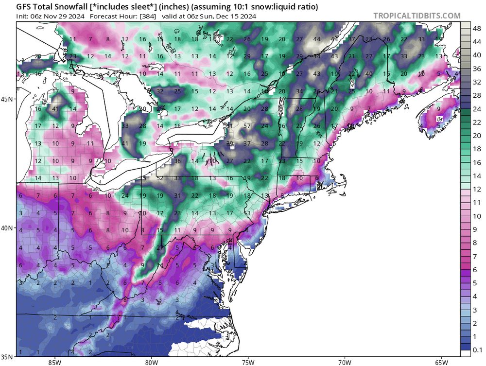
Still sticking to the Christmas storm. Been saying that since Ocober. We all need a nice Christmas day perid storm event for all the shit we have had to put up with the last 2 to 3 years of no t storms, the unbearble heat, drought and of course no fricking good snow events . We deserve a foot of snow for Christmas morning.
-
The upcoming pattern change on the 10-12th reverts back to the SOS. This drought is really going to be bad come January. The low flows in the limestone geology streams is beginning to freeze up the normally warm spring fed streams for the lack of a good flowing base flow. The trout population is literally being destroyed. I can only imagine how low the ground water table will be in February and how wells will dry up in the middle of winter. Even with a major snow event and with the ground frozen, no recharging of the groundwater table will take place for months. The latest moderate rains only put out the the chances of wild fires and did nothing for ground water table. I hope the storm on the 12th drops 2+ of rain or we are screwed as the forecast looks dryer than popcorn fart until around Christmas
-
pixie dust fairy lives on. In the donut hole now
-
I give up. The models are so wishy washy because of the evolving new LP pattern trying to setup after the 10th. I just hope that this new pattern opens the door for some GOM /Atantic Ocean moisture to get embedded into these progressive flow LP's and be able to spin up some noreasters our way. At this point, I will be happy to settle for some rain just to get the ground wet before it really freezes. This drought will not relinquesh its ugly head. The dusting of snow only hinders wildfire production as the creek levels are really dropping now in my area. Back into the 50's and 60's next week will not help either. People will be washing their cars big time with the ton of salt being dumped on the road tomorrow for the 1-2" snow squalls. Snow squall warnings will likely be issued tomorrow and your cell phones will be banging out the audible alerts Just hoping for a new wet pattern setup after the 20th and loaded to bear with continual snow events. A nice Christmas gift after this shitty summer and fall right Red Sky?
- 1,105 replies
-
- 1
-

-
- tropics
- heavy rainfall
- (and 5 more)
-
https://www.lowermac.com/DocumentCenter/View/2157/PRESS-RELEASE--Lehigh-County-Burn-Ban
-
C'mon man give me abreak now - plz let me enjoy my 1-2 inches of snow this week LMAO while we are still under a burn ban and drought. Until the 4 corners LP's start forming we are not going to get moisture laden storms around here but just constant clipper snows. Yes, my predicted cold air has come to fruition but the moisture still is lagging for good snow production storm events. I am really hoping for a Christmas week block buster snow event. The chances appear to be real good. The Great Lakes snow machine is also helping to keep the temps down for our area as the air coming over the lakes is not being modified like last year with unfrozen Great lakes
-
woopee a dusting LOL
-
my October 13th post drought guy here- saying that this drought will be broken by Thanksgiving with a heavy rain storm followed by a light snowfall event for the LV area. After an initial few weeks of cold/rainy and maybe even snowy weather into late November, the typical rain to snow precip pattern will return by the second week in December with decent cold snaps and maybe even some polar air reaching us by Christmas. Then the flood gates will be opened for some major snow events the rest of the winter with constant refreshed clippers - similar to the winter of 2003 after a blistering drought in 2002. ... Well , this has played out very nicely for me This mornings GFS run is spot on. Hope it stays like this
- 1,105 replies
-
- 1
-
-
- tropics
- heavy rainfall
- (and 5 more)
-
NO way. I am sticking to my original forecast last month for the upcoming time period- after the moderate rainfall events this past week, with a light snow event that I predicted, the flood gates open up for a period of some nice cold air. I am still calling for a snow accumaltion event during the Pearl harbor day period 12/6- 12/9 as I reierated last week as the pattern changes and reloads. A good meterologist sticks to his original thoughts- I have been burned too many times changing my forecast on a single model run. For those who even care? My usual forecast prediction method for thew last 30+years- the 10 day GFS sniffs out the potential weather pattern changes, the Euro/CMC confirms those changes from 7- 10 days out for the potential pattern change, sometimes attached with a significant storm event. The Euro then confirms the potential pattern change/storm event it 48-72 hours out. Between 36- 48 hours, I rely on the Meso's, especially the NAM, RGEM and HRRR's with 36 hours for total precip/wind info. Chaos playtime on the models with major unreliability issues usually occurs on the GFS and Euro between 4-8 days out with upheavel and reversals sometimes noted. This is the result of unreliable and lack of data info from the few ocean buoys in the western Pacific being ingested into the models. When the potential storm event/pattern change finally comes on shore usually at 3-5 days out, the LR models tighten up and come into some type of agreement. Then its off to the races.
- 1,105 replies
-
- 1
-

-
- tropics
- heavy rainfall
- (and 5 more)
-
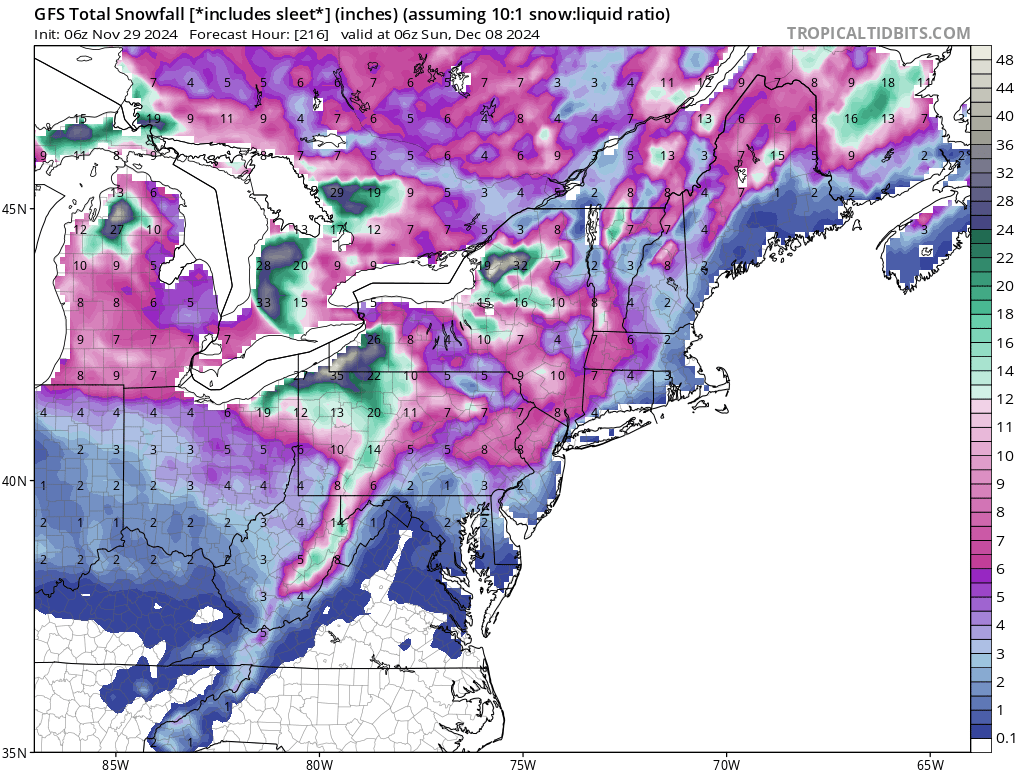
no moisture , no snow- let him honk. He is only exciting because his hometown in Ky will get snow while we still are moisture strarved The Apps and Allegany mts will suck out the moisture big time before it hits us as well as the real winner will be the lake effect snow areas. I am still counting on one small acumalating snow event by Dec 7 th and a nice Christmas day major snowstorm event
-
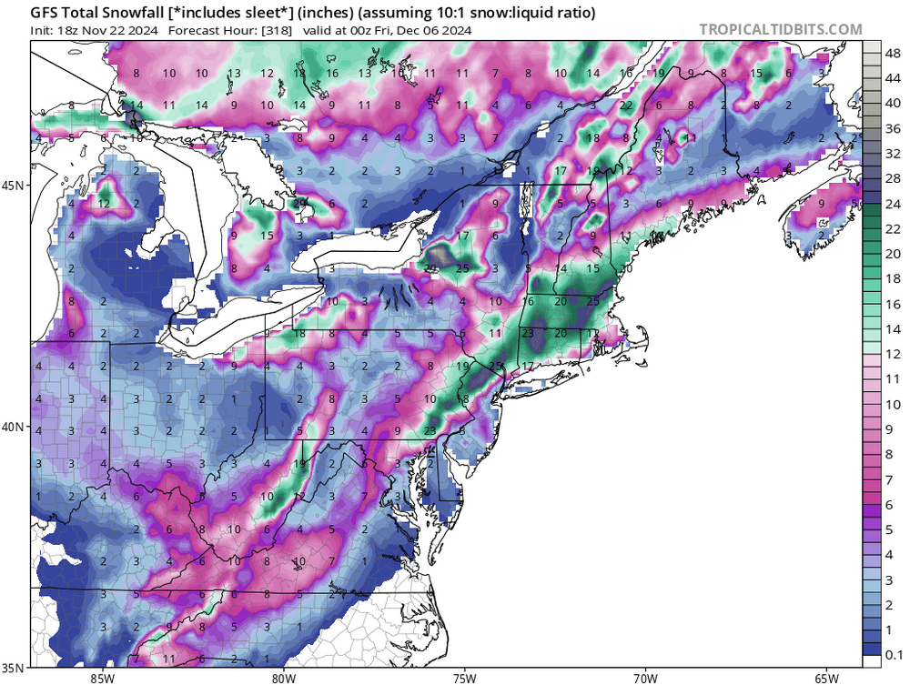
MY next big prediction LMAO -----Dec 6-7 first 6+ in snow for many in this region in two years . Always a Pearl harbor day snow storm event. Enjoy the sunny and 50 degree weather in the next three days- it will be short lived
- 1,105 replies
-
- 2
-
-

-
- tropics
- heavy rainfall
- (and 5 more)