

Albedoman
-
Posts
1,118 -
Joined
-
Last visited
Content Type
Profiles
Blogs
Forums
American Weather
Media Demo
Store
Gallery
Everything posted by Albedoman
-

December 2020 General Discussions & Observations Thread
Albedoman replied to bluewave's topic in New York City Metro
I am sorry but I do not see a real serious flooding issue with rainfall in this upcoming event for area. Past history in our area with these type of arctic frontal passages with a significant snow pack is that a good portion of the snow pack melts because of the formation of very dense fog (snow eater) in the warm saturated air before frontal passage which helps limits convective rainfall events even with warmer temps. I do however see some extensive snow pack melting from the dense fog from the high dewpoints and somewhat warm winds right before frontal passage but the frontal passage should be quick. I see the very brief heavy rainfall as a squall line with winds really gusty over 45 mph during and after the frontal passage . What concerns me is the front will move so quickly that you will have freezing rain/sleet and a significant flash freeze potential with a few inches of snow directly behind the front for most areas east of State College. The temps in eastern Pa/NJ will go from the mid to upper 40's to below freezing in less than two to three hours. Just my thoughts from over 30 years of watching these events unfold. I experienced the 1996 flooding and hit my house hard but that was a totally different animal than this arctic front. https://www.dep.state.pa.us/dep/deputate/watermgt/GENERAL/FLOODS/fld96rpt.htm -
no way in hell will sleet get this far north. Please provide proof. Please provide the KABE sounding showing that when Philly has not even at sleet yet
-
the 10:1 has 20 inches for the LV If sleet stays at bay , I would say 25 in is a good bet. Nothing like a good wish now and then. Either way you look at traveling on those interstates will be a living nightmare if they are not shut down between Harrisburg/Scranton and Allentown.
-
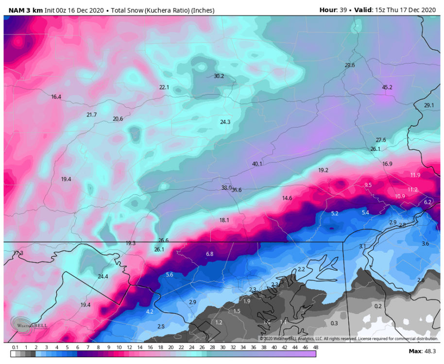
no worry, look at this map from the NAM. Snow tends to follow the geography. Anything East and South of South Mountain will be the tipping point for sleet. RT 78/81 from Allentown to Harrisburg gets crushed. Pottsville area is a good place to be and you are not that far from there. Rt 78/81 has to be closed down with 2-3 feet of snow period. No truck can get through that even with chains.
-
to all my weather friends on this forum. You are the first to know Just received this from PEMA Good Afternoon . Thank you con contacting the Pennsylvania Emergency Management Agency. The Governor will be issuing a State of Emergency Declaration for this snow storm (December 16-17). You will have to check with Lehigh County directly to see if they are going to issue a County Disaster Declaration. Regards. Tim Timothy L. Roth | Emergency Management Supervisor Private Sector Liaison External Affairs Office Pennsylvania Emergency Management Agency 1310 Elmerton Avenue | Harrisburg PA 17110-9713 www.PEMA.pa.gov | www.Ready.PA.gov Stay Calm, Stay Alert, Stay Safe Like us on facebook.com/PEMAHQ Follow us on Twitter @PEMAHQ and @PEMADirector Learn how to Be Informed, Be Prepared, and Be Involved at www.Ready.PA.gov
-
to all my weather friends here - received this late this afternoon . You are the first to know Just received this from PEMA Good Afternoon . Thank you con contacting the Pennsylvania Emergency Management Agency. The Governor will be issuing a State of Emergency Declaration for this snow storm (December 16-17). You will have to check with Lehigh County directly to see if they are going to issue a County Disaster Declaration. Regards. Tim Timothy L. Roth | Emergency Management Supervisor Private Sector Liaison External Affairs Office Pennsylvania Emergency Management Agency 1310 Elmerton Avenue | Harrisburg PA 17110-9713 www.PEMA.pa.gov | www.Ready.PA.gov Stay Calm, Stay Alert, Stay Safe Like us on facebook.com/PEMAHQ Follow us on Twitter @PEMAHQ and @PEMADirector Learn how to Be Informed, Be Prepared, and Be Involved at www.Ready.PA.gov
-
should not even be looking at the long range GFS runs now they are crap.- Euro, NAM and RGEM for the win The GFS shows a donut hole over the LV now- C'mon give me a break. For 4 days the LV has been in the jackpot zone. Trash the GFS in this range
-
this is for Macungie - I swear I was reading a forecast for Mammoth Mountain Ca. Most I ever seen actually predicted from one event: MT Holly real close in pulling the trigger for a issuing Blizzard warnings later this evening too. I think they should just to put more meat into the whiteout conditions under the winter storm warning that will exist to keep idiots from venturing out. Two feet of snow in 24 hours is just as bad as a blizzard IMHO Wednesday Snow, mainly after 1pm. High near 31. East wind 5 to 15 mph. Chance of precipitation is 90%. New snow accumulation of 3 to 7 inches possible. Wednesday Night Snow. The snow could be heavy at times. Low around 24. Northeast wind around 15 mph, with gusts as high as 30 mph. Chance of precipitation is 100%. New snow accumulation of 14 to 20 inches possible. Thursday Snow likely, mainly before 7am. Partly sunny, with a high near 32. North wind 5 to 15 mph, with gusts as high as 30 mph. Chance of precipitation is 60%. New snow accumulation of 1 to 2 inches possible. From the discussion: Even inland and back into the interior, wind gusts of 35-40 mph are possible. This would result in blizzard-like conditions, especially where snow is heaviest. It is too soon to issue a Blizzard Warning, and confidence is too low to warrant issuing one, but the potential is there.
-
I wonder if Mt Holly is considering hiking blizzard warnings for the LV tomorrow evening? The criteria will sure be there and the fact that the LV has consistently hit between 16- 24"+ snowfall predictions, having gust at or around 35 mph, snow ratios above 15:1, possible whiteout conditions for at least 4-6 hours during the heavy snow banding and being in or next to the jackpot zone on every model run for the past 48+ hours, I think it is warranted this time. I hope out all of this , I see enough convective instability to produce thundersnow. To me, that is way better than shoveling more than 12 inches of snow and helps make the storm memorable.
-
been snowing in the Lehigh Valley/Macungie PA for a few hours. Soon as the sun angle is lowered , more snow will be on the pavement. My backyard as of 30 minutes ago.
-
December 14th Rain / White Rain /Wet Snow obs
Albedoman replied to ChescoWx's topic in Philadelphia Region
My backyard in Macungie right now -
December 14th Rain / White Rain /Wet Snow obs
Albedoman replied to ChescoWx's topic in Philadelphia Region
already have over an inch on the ground with moderate to heavy snow the past two hours in Macungie. Starting to accumulate on the pavement surfaces as the ground cools. As the sun angle dwindles this afternoon, it should begin to pile up -
just for shitz and giggles for the snow weenies, this what the Lehigh Valley/ Allentown is showing. Of course I take but C"mon man- how unbelievable is a 41 inch snowfall? I would be happy with half of that. One thing, in every single model run for all the models for three days now, the LV has been close or near jackpot. That in itself is unbelievable.
-
i just cannot believe these snow maps. I all my years on this forum, I have never seen a clown map show such high snow totals. Even we get half of this, it is an ass kicking storm event with many hours of blizzard/whiteout condition as and record setting hourly snowfall rates and convective ( thunders snow) banding. This will be a storm to remember like 93 and 96 if it pans out.
-
I just cannot understand why Mt. Holly is gun shy about Mondays snow event. The NAM has been consistent now for days on showing at least 5 " in for the LV but tonights forecast says less than 1/2 inch. Evap cooling will overtake and they keep ignoring this possibility. I have seen it so many times in the LV in this situation. The ground temps are still cool as demonstrated by the ground by the dense fog advisory tonight? The model indicates at least an advisory level event for days now. Honestly, if Mondays event drops 4 in like I am expecting plus another 16+ in on Wednesday. it should set the record for the most snow in December for the LV. What a Christmas gift Additionally, the Wednesday snow event could be some major snow drifting issues that we have not seen here in nearly a decade or longer. It could be a storm to remember for sure. Nobody has brought that up along with a good chance of thundersnow has the low bombs out.
-
still in the bullseye 9" for the LV on the ECM
-
LV will get something at least. We have been in the bullseye for the CMC, Euro and GFS in todays runs for at least 6" or more. To see model agreement 7 days out is a nice change. I just hope they all do not agree to take it ups the Apps or out to sea in later runs. If its an inland runner, dam I hate cold rains. If the LP sits over the Chesapeake Bay area, big time snows accumulations when it goes negative tilt for NW of the fall line- can you say CCB set up?
-
for my 30 years of forecasting snow in eastern PA, I can firmly tell you historically that in a dying La Nina pattern that nothing will come to fruition as far as a major snow event until around Martin Luther Kings day- then watch out out. I expect to see decent chances of several 4-6 inch snowfall events before and after just after Christmas and then the snow bucket will be buried after 1/18/202. The pattern really sucks right now with the weak cold shots not aligning with the lp formation along the eastern seaboard. Cold dry warm rain is normal for this time of the year. Need a few strong clippers to keep the cold air in place and for gods sakes we need to get the lake effect snow machine going to even have a decent chance. So far that is even pitiful too with no snow covering to keep the cold air in place from warming so much before going over the Apps. Mts. This pattern will be ripe for a major ice storm come in January before the pattern changes too.
-
no, I am a soil/geological scientist . Name calling gets you absolutely no credibility as having a physical science background for sure on this site. With warm overnight temps, the soil temps cannot drop and grass keeps growing. 15+ degree avg temps overnight temps will not place cool season grass in dormancy Soil temperature is not the same as air temperature Soil temperature is not the same as air temperature. The earth acts like a giant radiator. It gradually absorbs the suns energy over time, and then releases it slowly. Air temperature can fluctuate dramatically as day turns to night and as the seasons progress. Soil takes a long time to change temperature. In the spring, the soil is cold from the winter and can take a long time to heat up. This is why spring scarification and lawn repairing can pose problems due to the soil not having warmed sufficiently. Seed may not germinate quickly and grass growth can be sluggish. Using an infra red thermometer to check soil temperature In the autumn, the opposite is true. The air temperature maybe falling, but the soil retains a lot of heat. This helps seed germination and aids the grass in absorbing valuable nutrients from autumn fertilisation. Many lawns can continue to look green and lush well into autumn and early winter. Autumn is usually the best time for seeding and major lawn renovation work.
-
another crappy night to sleep if you like cold crisp fall nights - windows open still in the low 50's at 1 am Mt Holly says to 38--- no way in hell with the stratus cover again. Avg low for my area is 30 degrees- I stand over 20 degrees above normal right now. I will be mowing until January at this rate.
-
I wonder if anyone from Mt Holly has done a study on how warm it has been since late May during the overnight hours compared to normal years? To have nighttime hours 10-15 degrees above normal constantly and sometimes even 20 degrees has been a real son of gun for sleeping with the windows open. The grass continues to grow, the green mold growing on everything outside from the decomposition of fallen leaves/ light rain, mold counts still high and continuing cloud cover. Yes the heater has not run much but really, I do like to see frosty mornings during the fall. This year's constant stratus cloud cover at night has been just plain unbearable
-
well the first legit snow/sleet/ white rain chance in less than 2 weeks for eastern pa. We will see
-
E PA/NJ/DE Spring 2020 OBS Thread
Albedoman replied to Hurricane Agnes's topic in Philadelphia Region
snow showers in Macungie weird at 45 degrees. Air is really cold upstairs -
E PA/NJ/DE Spring 2020 OBS Thread
Albedoman replied to Hurricane Agnes's topic in Philadelphia Region
still looking at some snow by the end of the weekend for the LV ---models still honking to at least seeing it. Accumulation - a dusting in the LV little more on the hills. People will be surprised and it will be newsworthy over the CV virus for a change.
-
E PA/NJ/DE Spring 2020 OBS Thread
Albedoman replied to Hurricane Agnes's topic in Philadelphia Region
still seeing snow by this weekend in the LV . Wed- Sun time frame CMC, NAM honking but its a close call. Poconos will see snow though


