Albedoman
-
Posts
1,118 -
Joined
-
Last visited
Content Type
Profiles
Blogs
Forums
American Weather
Media Demo
Store
Gallery
Everything posted by Albedoman
-
This satellite picture in the last hour explains my previous post. Look at the ohio valley where there is sun- thats where the heavy rain/t storms are. NO convective environment anywhere in E PA .
-
another joke of forecasted heavy rain event today thus far. These dying t showers are worthless from the Ohio Valley. The PWAT's modeling maybe high but the NER's are off the charts. IMHO, the NERS must be weighed against the PWAT to determine realistic probabilities of heavy rain events. With the constant debris stratus clouds and no diurnal sunshine, the convective aspect for the formation of high PWAT ratios are essentially nill and with the NER's so low too, its impossible to achieve heavy rain events. Lets hope the sun peeks out later somewhere west of Reading before the sun sets
-
I swear this video depicts some areas of our region of localized downpours are really like this summer LMAO https://www.itemfix.com/v?t=cm5e71
-
Really a debbie downer. I was expecting lows in the mid 50's with decent dewpoints and a little breeze. Boy am I suprised when the overnight lows barely just reached 60 degrees with dewponts still in the low 60's. All Debby did was raise the humidities in the overnight areas, promote mold and mushroom growth. The worst part is there is no breeze at all in the evening. The midwest is getting the refreshing airmass. By the time it reaches here, it will warm up another 5-10 degrees at night. Record lows in the Great lakes - upper 40's to lows 50's here jack squat. The windows will stay shut as the dewpoints still remain in the 60's. If you open yoor windows, you are basically allowing the heat to create steamy conditions in the house in the evening with no breeze. Its really pitiful when the windows steam up the last few mornings on the outside even when I set the temps in the house in the house at 70 degrees. When does a real Canadian air mass over us? LOL
-
Unbelievable- canceling Kutztown festival today over drizzle. These people must be out of their mind. You think it was 33 degrees and a cold ass rain with sleet outside. Its 75 degrees. The fair sponsors wonder why attendance will be down. Cry wolf and this is what yoou get. Music fest is just as bad. But get this, if the event was the garlic fest or baconfest, they would go on even if a hurricane was hitting them directly
-
Last nights total .45 in Lower Macungie,Ancient oaks . Not a flooding event for sure. In the last two hours however, I have received nearly .50 inch of rain with these very localized tropical downpours. Hardest rains for awhile here. Cannot wait until Sunday/Monday with the the new airmass. The skies should be a deep blue with Debby washing out all of the heat, haze/smoke, pollen and humidity
-
the flooding rains were pretty bad -NOT. Did have two hours of some light to moderate rain from the dying storms. The precip donut hole still exists over southeastern Lehigh County into Northern Montgomery and Bucks. Well, maybe Frday offers some hope. While the 95 crew gets literally washed away, the 78/222 crew is dying of thirst and stays in the 90's. It was not predicted to be in the mid 90's yesterday either. The only thing that I got was a bunch of down branches for the dozen time this summer -please no more downdrafts from the dying t-storms.
-
Complete miss in Western Lehigh county what a joke The winds were gusty about 45 miles an hour I spent the last 45 minutes picking up tree limbs. Music fest is being hammered however
-
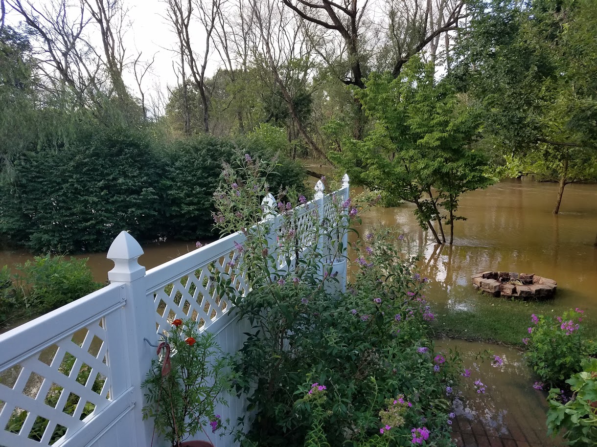
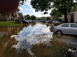
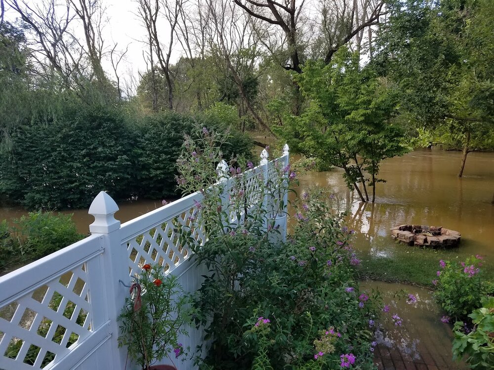
C,mon man, my location in the bullseye for Saturday? These models are garbage. Lets see how many times this changes in the next five days. 11 in of rain. If this scenario actually happens, it will be the worst foods ever to hit Lehigh Valley. Isaias was bad enough in 2020 with 8 in of rain in 24 hours. here was my front yard in the pic below in 2020.
-
Laugh now Ralph, but watch the storm take a wide right and leave us all wondering what the hell happened. I will not believe the models precip runs again until my rain gauge registers two inches of precip and the precip is actually called for. These precip models have been poor in their guidance all summer. Hit and miss t storms will not make the cut. Even Mt Holly has had trouble with posting 60-80 % chances of precip and then changing their forecasts two- four hours later and lowering the aerial coverage to 20%. I have been using my leaf blower after every t storm because of the amount of scorched leaves from the trees being blown off from the gusty winds with little to no rainfall. It appears MT Holly is already downgrading the precip totals between forecast periods this morning too going from 1-2 inches to less than an inch in the last four hours. Enjoy your tropical rains.
-
Double the chances of sprinkles. Lines are falling apart bigtime
-
The crap that's coming our way in the next hour will find a way to manage to Miss all of us
-
well like i said in an earlier post, the drought watches are coming. Here is the first of many notices from private water companies. This morning- a few sprinles thats it. https://www.wfmz.com/news/area/berks/mandatory-water-restriction-in-effect-for-the-north-heidelberg-water-system/article_82ef7f16-517e-11ef-ad4f-9b7a759f97d5.html
-
You mean there is a chance----- LMAO
-
absolutley nothing- .02 in. The storms hit the Lehigh County line and literally died. Stiff breezes for the 1000th time - scorched leaves everywhere with small twigs and just enough rain to wash the dead bugs off the windshield. Drought watches coming if we get no significant rain by next weekend. Meanwhile we continue to bake. Mid tu upper 80 degree highs with 70 degree lows is awful ----that is not a cool down.
-
looks like a real good chance of precip in the next 30 min for Lehigh county. Like the rardar returns- Severe maybe?
-
c'mon man. Guidance has not been right all year for precip.
-
well, here it is again. At 3 am in the morning- 77 degrees with cloudy skies. No chance in hell of reaching the dewpoint again as the clouds heat up the ground. For the upteenth time this summer, debris clouds from dying dinural t- storms in central and western PA that never reaches us by sunset lie directly over east cental pa essentially baking us at night. Far worse than during the day thats for sure. No condensation relief from not reaching the depoints means the ground is baking and the plants start wilting and any dust and pollen on the cars turns to cement. When the debris clouds finally clear out by noon the next day, the oven door is opened up again, exceeding the forecasted highs. Rinse and repeat. This pattern really sucks and worst of all the accuracy for precip chances forecasting is even worse.
-
just unbeliveable- these t storms tonight hit the blue mountains and go directly north. 60-80% chance of rain went straight to hell this week. The lawn looks like a crabgrass factory with these hot overnight lows. Today it hit 92 in Macungie- five degrees higher than they thought. Tomorrow will be in the mid to upper 90's for sure. Where is the heat advisories?
-
lmao. It will take a TS to kill this heat and dryness ONLY. Dying cold fronts that hang over our region are no longer. They go right out to sea or come back as dry warm fronts with no convective material. Wash and repeat every week for the past 3 months. We need a dying cold front to reach the carolinas and form an LP on the front. That is not in are cards
-
Its a been a long time since I have seen precip chances dwindle so quickly - from 70-80 % to less than 20% in susbsequent forecast updates. With no significant rains in the next 10 days with another heat wave by next Tuesday- things are going to get real ugly in western lehigh County. This heat is simply relentless. Its warmer here than Memphis TN. Where are these so-called tropical storms to break this pattern? All TS remnants have gone up to Canada. No forest fires this year.
-
of course zilcho for Lehigh County. I feel like this steam bath atmosphere is a joke. The grass is decimated from the heat. Overnight lows failing to get out of the 70's is a perfect atmosphere for breeding west nile virus mosquitoes in sept let alone record breaking. Its not the daytime highs, its the overnight lows that are unbearbable
-
WE should be having boomers every afternoon with this humidity. Where is the convection? Drizzle is not going to help the drought conditions. Two days of spotty drizzle with temps in the upper 80's to near 90 with cloudy days will not cut it. 70% chance of precip should be reduced to 20-30% at this time. This crappy east west dying pattern is stubborn and will not move away. Bring on the TS to destroy this pattern.
-
Yes indeed- nada- drizzle and less than .02 of rain last night. The ring of drought still lingers around eastern Berks and western Lehigh
-
that sucker will never make it here in the southern Lehigh county area. Dry as a bone the last 24 hours. The block wall remains tight. Everything to the NW and SE of eastern PA for precip. Mt Holly needs to reduce the precip chances bigtime.