Albedoman
-
Posts
1,154 -
Joined
-
Last visited
Content Type
Profiles
Blogs
Forums
American Weather
Media Demo
Store
Gallery
Everything posted by Albedoman
-

E PA/NJ/DE Spring 2025 Obs/Discussion
Albedoman replied to PhiEaglesfan712's topic in Philadelphia Region
The south mountairange and bear creek ski resort elevation makes a huge difference in these type of events, Alburtis zip is closest to the elevation of Bear Creek -- 1500 ft + I a escaped with 1.5 in up on the ridges 2+ is easily attainable at nearly 1500 ft. -
E PA/NJ/DE Spring 2025 Obs/Discussion
Albedoman replied to PhiEaglesfan712's topic in Philadelphia Region
for those who have not seen snow south of the LV the last 45 days- here is what it looks like. LOL This was after 8 AM and everything was starting to melt after being covered except the streets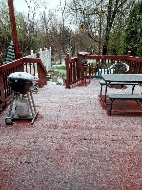
-
E PA/NJ/DE Spring 2025 Obs/Discussion
Albedoman replied to PhiEaglesfan712's topic in Philadelphia Region
less than .5 of snow. Flakes this morning were like pancakes. Received needed rain however 1.10 in. Going into the next week with much needed moisture for tree leaf out. Feel good that the drought is going bye bye if this keeps up by the end of the month. Just bring on the 70's now. Want to turn off the heater. Cloudy 40-50 degree days raise the utility bills for sure. -
E PA/NJ/DE Spring 2025 Obs/Discussion
Albedoman replied to PhiEaglesfan712's topic in Philadelphia Region
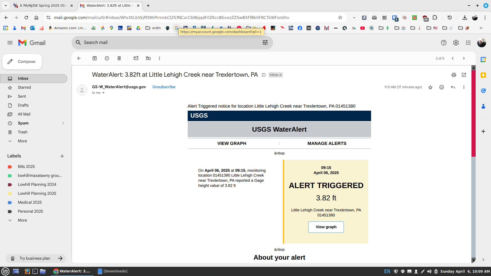
The precip was really beneficial to the Little Lehigh Creek watershed. I just received my first USGS gauge flood alert on the Little Lehigh at RT 100 this year. My personal alerts are calibrated to when the stream jumps out of it banks, which visibly it has. Once it gets to around 4.5 ft, Spring Creek Rd is completely underwater. The USGS staff from state college and myself have successfully calibrated this new telemetry digital gauge over the last 2-3 years for issuance of flash/flood warnings in our area. Thats why I am called the drought guy. LOL
-
E PA/NJ/DE Spring 2025 Obs/Discussion
Albedoman replied to PhiEaglesfan712's topic in Philadelphia Region
1.35 here in LMT. First time since New Years day that I have seen the Little Lehigh at bank-full and running muddy this morning. Not a good day to trout fish for sure. The headwaters of the Little Lehigh finally received some decent precip. Put a real nice dent in the drought conditions for the entire watershed. Waiting for the snow and graupel for tomorrow. -
E PA/NJ/DE Spring 2025 Obs/Discussion
Albedoman replied to PhiEaglesfan712's topic in Philadelphia Region
dusting of snow with graupel a good bet as cold air advection works in. Best chance of frozen precip since Feb LMAO -
E PA/NJ/DE Spring 2025 Obs/Discussion
Albedoman replied to PhiEaglesfan712's topic in Philadelphia Region
the thundershower I hoped for. maybe more later -
E PA/NJ/DE Spring 2025 Obs/Discussion
Albedoman replied to PhiEaglesfan712's topic in Philadelphia Region
Lagavulin. Neat. Clear alcohols are for rich women on diets.” The story goes that when coming up with characters for his hit sitcom 'Parks and Recreation', creator Michael Schur snuck in one autobiographical detail into the grouchy but loveable protagonist, Ron Swanson – his love of Lagavulin whisky. -
E PA/NJ/DE Spring 2025 Obs/Discussion
Albedoman replied to PhiEaglesfan712's topic in Philadelphia Region
click bait. -
E PA/NJ/DE Spring 2025 Obs/Discussion
Albedoman replied to PhiEaglesfan712's topic in Philadelphia Region
I am hoping for a t- shower later tonight. Radar down sw near MD looks promising right now but the stable air will most likely kill any good chance of instability -
E PA/NJ/DE Spring 2025 Obs/Discussion
Albedoman replied to PhiEaglesfan712's topic in Philadelphia Region
well, I am clearly disappointed that we missed out on all the significant rain again this morning. The fronts hanging up over the mid south and to the NW of our area just will not allow any GOA moisture to get up here. Light rain showers are not going to cut it for ending this drought. Sundays t-storms rains chances with heavy rain are dying as I write. The dry cold winds also return with a vengeance. We are screwed from Monday on with Tuesday feeling like winter and the heater on full blast. Would not be surprised to see flurries/graupel in the LV. I am tired of being teased. Incredible how the Memphis TN area nearly gets a foot of rain and we cannot even squeeze out a popcorn fart of decent precip. -
E PA/NJ/DE Spring 2025 Obs/Discussion
Albedoman replied to PhiEaglesfan712's topic in Philadelphia Region
not yet. Most of my seminars/lectures that I have given in the past 20+ years deals with stormwater planning , local flooding issues, sinkholes in Karst topography, zoning and municipal planning and naturalization of best management stormwater practices with the EPA, PADEP, USGS and county planning commissions. My drought experience comes from living in S Calfornia /brush fires/mudslides for 10-15 years -
E PA/NJ/DE Spring 2025 Obs/Discussion
Albedoman replied to PhiEaglesfan712's topic in Philadelphia Region
Judging science fair right now. Ai enso modeling in my section along with using drones as a weather ballon for getting profies with sensors -
E PA/NJ/DE Spring 2025 Obs/Discussion
Albedoman replied to PhiEaglesfan712's topic in Philadelphia Region
Yep, that is what i said would happen before it rained -
E PA/NJ/DE Spring 2025 Obs/Discussion
Albedoman replied to PhiEaglesfan712's topic in Philadelphia Region
most areas around me have received above 1.25+ in of needed rainfall. The areas in Northern LV received less than a half an inch. The jackpot area was basically south of I-78 -
E PA/NJ/DE Spring 2025 Obs/Discussion
Albedoman replied to PhiEaglesfan712's topic in Philadelphia Region
I agree. The stratiform moderate rain falling right now with embedded thunder is the first true dent in our persistent drought since last summer. The ground is taking every bit of it for once as the the soils were not frozen. 3-5 more events like this in the next 30 days will end the drought conditions. The base flows will come in the creeks in the morning. -
E PA/NJ/DE Spring 2025 Obs/Discussion
Albedoman replied to PhiEaglesfan712's topic in Philadelphia Region
wahoo, finally, some thundershowers and moderate/heavy rain at times Not a gully washer or a drought buster, but I will take it. The nice part is the thundershowers. Lighting means extra nitrogen in the rain which will green up the trees and grass real nice and quickly. All the yellow and brown grass will be gone by the end of week. The trees will really bud by the end of the week too. -
E PA/NJ/DE Spring 2025 Obs/Discussion
Albedoman replied to PhiEaglesfan712's topic in Philadelphia Region
can i smoke what you are smoking? LOL.NO heavy precip until temps in the mid to upper 70's. No warm temps, no convection. -
E PA/NJ/DE Spring 2025 Obs/Discussion
Albedoman replied to PhiEaglesfan712's topic in Philadelphia Region
Wopee drought getting worse. Less than a half of an inch all week. Fire conditions getting real bad with dry underbrush. When will padep noaa wake up? Extreme drought folks. By the way, i warned you about the sinkholes i-80 closed from sinkholes. Now i-287 has sinkholes. Drought monitor map is bs right now. They need to look at palmer indices -
E PA/NJ/DE Spring 2025 Obs/Discussion
Albedoman replied to PhiEaglesfan712's topic in Philadelphia Region
just in time to dry out the soil profile by mid afternoon. -
E PA/NJ/DE Spring 2025 Obs/Discussion
Albedoman replied to PhiEaglesfan712's topic in Philadelphia Region
bring it on. How about a severe t storm warning to boot? Still waiting for that 30 in snowfall event to hit us in few weeks LMAO -
E PA/NJ/DE Spring 2025 Obs/Discussion
Albedoman replied to PhiEaglesfan712's topic in Philadelphia Region
the progressive LR patterns we ar in are not even worth looking at at this time for the GFS model. Look at a 3-5 day models instaead- more reliable -
E PA/NJ/DE Spring 2025 Obs/Discussion
Albedoman replied to PhiEaglesfan712's topic in Philadelphia Region
drought is not measured by the moisture of the first 3-6 inches of topsoil. It is measured by groundwater elevations and base flows of streams. WE have a long way to go to break this drought. Like I said in my posts, .25 in rains are good for greening grass only. However 40 mph winds after tonights rain will dry the surface by tomorrow evening. Elevated fire risks for the weekend if the winds keep up. The dry period has been ongoing since August 18 th, 2024 the last day of a two inch rain for the LV. Since then, it has been a desert. -
E PA/NJ/DE Spring 2025 Obs/Discussion
Albedoman replied to PhiEaglesfan712's topic in Philadelphia Region
gfs shit the bed already. 2-3 feet of snow gone -----That model needs to be shelved until we have a better non-progressive weather pattern. The 30 mph+ Santa Ana type winds return on Friday immediately drying out any rain we get on Thursday. No water recharge into the ground except the first couple of inches of topsoil. Again, this .50 inch of rain is great for greening the yards and for spring bulbs but the groundwater table for water supply and base flows for the limestone streams are falling real quick as the trees start to bud. The leaves will start to open in 3-4 weeks and then we are in real trouble as the uptake of any residual moisture in the soil is gone. NOAA and PADEP must issue a drought emergency for the LV before the water authorities do it on their own with rationing. The weather discussion keeps saying beneficial rains are coming-- just like the 3 ft of snow on the GFS model but actually .25 to .50 in rains are not really beneficial when we have drying wind advisory events right behind the fronts. NJ is not the only area of the MT Holly region. The LV has not received a single 2 in rain event since August 18, 2024 and only a couple of single rainfall events barely over an inch since then . We are going on below normal precip for 9 months now. Folks, that is a hell of drought. The 2-3 inches of rain in NJ this past weekend killed the existing drought conditions along SE NJ with their sandy soils and above avg snowfall so far this year. Lets start hearing more about the million + people that live in the I-78 corridor and the daily brush fires in the weather discussions. Thanks -
E PA/NJ/DE Spring 2025 Obs/Discussion
Albedoman replied to PhiEaglesfan712's topic in Philadelphia Region
The huge snow amounts will be gone by the 18z tomorrow - Reliable Data ingestion from the PAC has not even been incorporated into the models yet. When it is less than 5 days from the event with all three LR models on board , then I will be concerned. This BS scenario has happened at least three times in February. Reliable LR forecasting for snow amounts has been non-existent in this weather in this progressive pattern. T- storms die out , heavy rain disappears over the Blue Mts as well. The only dam weather phenomenon that is a sure thing in this crappy pattern is a dry adiabatic wind over the mountains with gusts over 30 mph for days on end that causes diurnal temp fluctuations of 25- 30 degrees everyday.