rockchalk83
-
Posts
375 -
Joined
-
Last visited
Content Type
Profiles
Blogs
Forums
American Weather
Media Demo
Store
Gallery
Everything posted by rockchalk83
-

MO/KS/AR/OK 2020-2021 "Winter" Discussion
rockchalk83 replied to JoMo's topic in Central/Western States
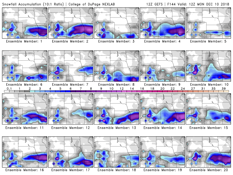
I'd be interested in seeing the individual member breakdowns to see if they are as robust as the op run? My feeling is that the heft from the op run contributed to the big jump in totals in C KS. -
MO/KS/AR/OK 2019-2020 Winter Wonderland Discussion
rockchalk83 replied to JoMo's topic in Central/Western States
The 3KM NAM with a little different look than it's traditional counterpart. The biggest headache with the forecast is going to be where the system matures...along and northwest of that point, is going to be where the heaviest snow falls. Unfortunately, we may not know that until the high-res hourly runs tomorrow, even though the system will be fully sampled in later model runs today.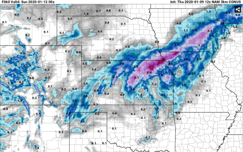
-
MO/KS/AR/OK 2019-2020 Winter Wonderland Discussion
rockchalk83 replied to JoMo's topic in Central/Western States
I'll agree with MUWX's assessment that the bulls eye right now is between I-70 and I-44. Something to keep in mind here is that this isn't the typical winter system we have out here, where we have a huge low coming out and a large precip shield. Rather, this is a rather weak low and the event will be driven by warm air advection processes. The whole forecast is going to hinge on where the baroclinic zone sets up, as that will be the axis that sees the 2-8" snows. Overall, for it being >3 days out, the models have a good agreement on some type of winter storm out here this weekend. It will be nice to see some snow over a widespread area, since most of us have been dry for a while. -
Central/Western Medium-Long Range Discussion
rockchalk83 replied to andyhb's topic in Central/Western States
If the mean trough is in the Southwest US, wouldn’t that mean more severe weather for our region? -
MO/KS/AR/OK 2019-2020 Winter Wonderland Discussion
rockchalk83 replied to JoMo's topic in Central/Western States
Here you go: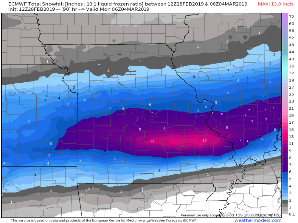
-
MO/KS/AR/OK 2019-2020 Winter Wonderland Discussion
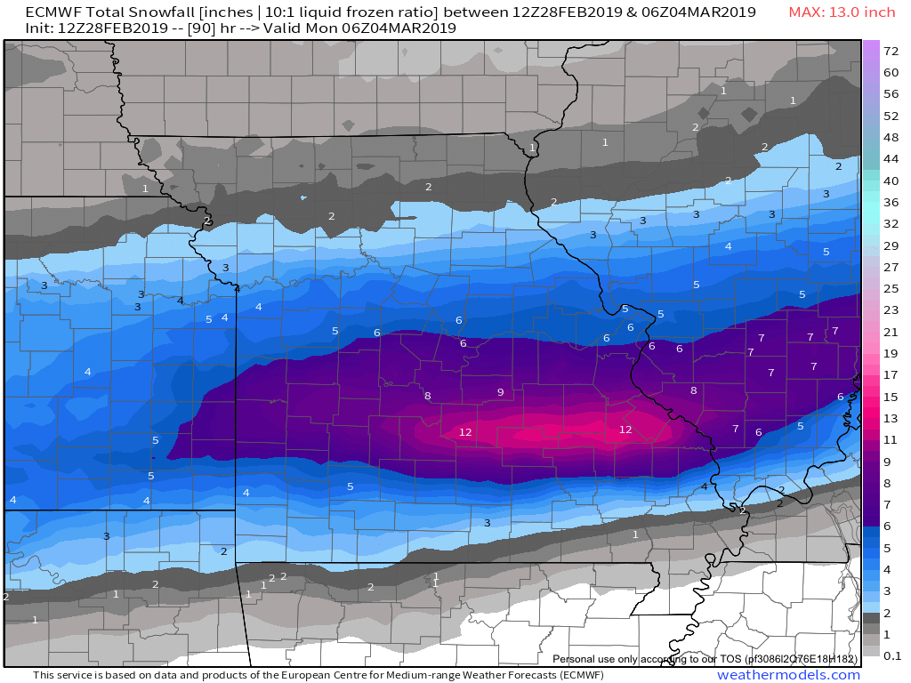
rockchalk83 replied to JoMo's topic in Central/Western States
Here is Kuchera snowfall off the Euro: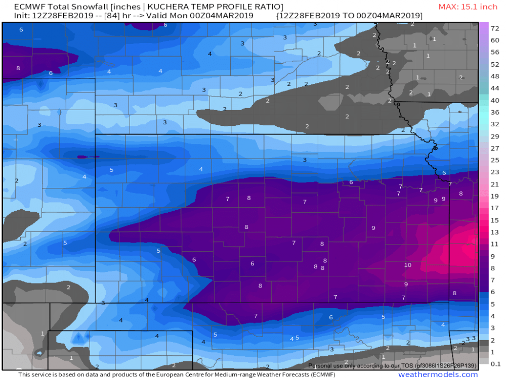
-
MO/KS/AR/OK 2019-2020 Winter Wonderland Discussion
rockchalk83 replied to JoMo's topic in Central/Western States
Some places in SC KS got 10 inches of snow. The town of Kingman, just west of Wichita, picked up 3 inches in one hour as a band really intensified overhead. This banding feature was really well forecasted, starting with the 18z NAM on Monday and continuing throughout the event. -
MO/KS/AR/OK 2019-2020 Winter Wonderland Discussion
rockchalk83 replied to JoMo's topic in Central/Western States
Seeing ice storm warnings go up for the KC and Joplin areas...and it's possible those could be expanded south and west later. HRRR, RAP & ECMWF all prog significant freezing rain event (>.2") in C & E KS into NW MO tonight. Meanwhile, storms going up south of the stationary boundary in C OK. -
MO/KS/AR/OK 2019-2020 Winter Wonderland Discussion
rockchalk83 replied to JoMo's topic in Central/Western States
Here's a look at 925 mb winds based off the GFS for Saturday morning at 6 am. The red indicates winds at 50-55 kts about 2000 feet off the surface. If this verifies, then we may very well have blizzard conditions across C & E KS into parts of West Missouri.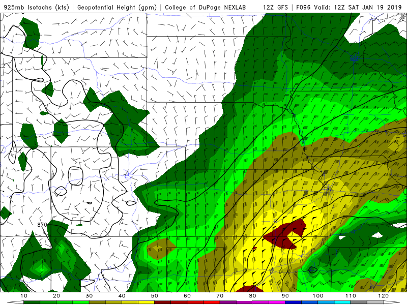
-
MO/KS/AR/OK 2019-2020 Winter Wonderland Discussion
rockchalk83 replied to JoMo's topic in Central/Western States
Agree with this. When you look at the winds that are progged behind the cold front, we could very easily have blizzard conditions over a wide area if this comes to pass. FWIW, the 12z GFS ensembles had a much snowier solution than the operational run. -
MO/KS/AR/OK 2019-2020 Winter Wonderland Discussion
rockchalk83 replied to JoMo's topic in Central/Western States
If the latest NAM/Euro/Canadian models are right...that will have to be shifted west and increased. -
MO/KS/AR/OK 2019-2020 Winter Wonderland Discussion
rockchalk83 replied to JoMo's topic in Central/Western States
Right there with you, especially after what the 18z NAM and 12z Canadian is showing. -
MO/KS/AR/OK 2019-2020 Winter Wonderland Discussion
rockchalk83 replied to JoMo's topic in Central/Western States
I’ll take ALL of that. But it’s the NAM at >12 hours so... -
MO/KS/AR/OK 2019-2020 Winter Wonderland Discussion
rockchalk83 replied to JoMo's topic in Central/Western States
This troll job, courtesy of the 12z GFS-FV3
-
MO/KS/AR/OK 2019-2020 Winter Wonderland Discussion
rockchalk83 replied to JoMo's topic in Central/Western States
Completely agree. It will be one of those systems where it will be 36 or 37 and snowing but will take 1-2"/hour rates to accumulate on roads. -
MO/KS/AR/OK 2019-2020 Winter Wonderland Discussion
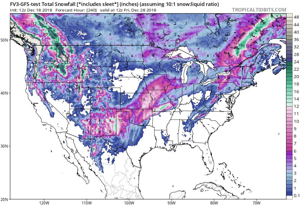
rockchalk83 replied to JoMo's topic in Central/Western States
Here's the 06z GFS-FV3 for comparison. It lines up well with it's older counterpart, plus the 00z EURO & 00z Canadian: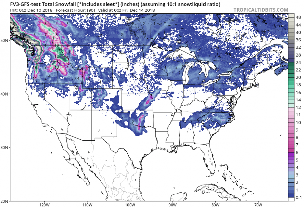
-
MO/KS/AR/OK 2019-2020 Winter Wonderland Discussion
rockchalk83 replied to JoMo's topic in Central/Western States
Gross. -
MO/KS/AR/OK 2019-2020 Winter Wonderland Discussion
rockchalk83 replied to JoMo's topic in Central/Western States
Gonna need details...lol -
MO/KS/AR/OK 2019-2020 Winter Wonderland Discussion
rockchalk83 replied to JoMo's topic in Central/Western States
As it relates to the 18z NAM...it's closing off the 500 mb low much more aggressively than the others so far....with a 558dm low along the Red River. That process is the reason for the higher totals. Something to watch for sure, as the other models in the 12z suite have hinted at a closeoff, which would portend to a farther north track. -
MO/KS/AR/OK 2019-2020 Winter Wonderland Discussion
rockchalk83 replied to JoMo's topic in Central/Western States
I cannot help but wonder how much of the hot colors...especially along the I-44 corridor and especially in AR...falls as sleet? Could be a substantial amount. -
MO/KS/AR/OK 2019-2020 Winter Wonderland Discussion
rockchalk83 replied to JoMo's topic in Central/Western States
I’ll take it! 8” up here in SC KS -
MO/KS/AR/OK 2019-2020 Winter Wonderland Discussion
rockchalk83 replied to JoMo's topic in Central/Western States
The 12z Euro is only out to 18 hours on Weathermodels.com. Are you getting it quicker somewhere else? -
MO/KS/AR/OK 2019-2020 Winter Wonderland Discussion
rockchalk83 replied to JoMo's topic in Central/Western States
The NAM says no. Not even a shift north to bring S KS & S MO into play. >12" of snow for the I-44 corridor, though. -
MO/KS/AR/OK 2019-2020 Winter Wonderland Discussion
rockchalk83 replied to JoMo's topic in Central/Western States
With a more amped system as the NAM & Euro would depict, is there a chance the system moves back north? The 18z GEFS seemed to suggest some decent snow accumulations into southern Kansas and Missouri. -
MO/KS/AR/OK 2019-2020 Winter Wonderland Discussion
rockchalk83 replied to JoMo's topic in Central/Western States
Here are the GFS ensemble forecast snow accumulations from the College of Dupage: