rockchalk83
-
Posts
375 -
Joined
-
Last visited
Content Type
Profiles
Blogs
Forums
American Weather
Media Demo
Store
Gallery
Everything posted by rockchalk83
-

MO/KS/AR/OK 2020-2021 "Winter" Discussion
rockchalk83 replied to JoMo's topic in Central/Western States
Tight rope for Wichita. If we get >4” of snow, it will be the biggest storm in almost 7 years. Insane. -
MO/KS/AR/OK 2020-2021 "Winter" Discussion
rockchalk83 replied to JoMo's topic in Central/Western States
The NAM, GFS, and Euro have been ultra consistent... -
MO/KS/AR/OK 2020-2021 "Winter" Discussion
rockchalk83 replied to JoMo's topic in Central/Western States
It implies the system would be stronger and potentially take on a negative tilt. -
MO/KS/AR/OK 2020-2021 "Winter" Discussion
rockchalk83 replied to JoMo's topic in Central/Western States
Interesting note from NWS Norman regarding the 12z model initializations. FWIW, the 21z RAP edged west with the main precip shield, while the 18z Euro maintained. The complicating factor with this forecast is that for precipitation amounts and types with the cyclone, the models widely diverge in solutions and the impacts that result from the solutions. In discussions with WPC, the GFS/NAM 12z initialization had a 30 meter initialization error in the 500mb height fields, which should have a sharper upper-level trough. For this forecast more weight was put towards the ECMWF solution for precipitation location and type, however the forecast for precipitation type/impacts could drastically change with any shifts in path of the cyclone. -
MO/KS/AR/OK 2020-2021 "Winter" Discussion
rockchalk83 replied to JoMo's topic in Central/Western States
I will give up weather if that happens. What a close shave! -
MO/KS/AR/OK 2020-2021 "Winter" Discussion
rockchalk83 replied to JoMo's topic in Central/Western States
FWIW, the 12z HREF from the SPC is fairly similar to the Euro in track and slightly colder. It has a wide area of 1/4-1/2" ice across SE KS, SW MO and NE OK. With the wind that's forecast with this, power outages are going to be a distinct possibility. -
MO/KS/AR/OK 2020-2021 "Winter" Discussion
rockchalk83 replied to JoMo's topic in Central/Western States
That's a big area of heavy freezing rain on the Euro for 12z Friday. Yikes. -
MO/KS/AR/OK 2020-2021 "Winter" Discussion
rockchalk83 replied to JoMo's topic in Central/Western States
It is interesting to note that the short-term models (granted, they're still just coming into their respective time domains) do not have the system as far west as the ECMWF, GFS, ICON models. Just a slight nudge east. Will be interesting to see if that trend continues as the system gets into better focus for the high-res models. -
MO/KS/AR/OK 2020-2021 "Winter" Discussion
rockchalk83 replied to JoMo's topic in Central/Western States
Looks like model initializations were all over the place on the 00z suite of runs. It is interesting to note that the 06z HRRR (48 hrs) was among the colder of the models, with a larger area of sleet and snow. Will be something to follow today as that could significantly ratchet up snow totals for western Oklahoma into Kansas. -
MO/KS/AR/OK 2020-2021 "Winter" Discussion
rockchalk83 replied to JoMo's topic in Central/Western States
Generally, if the snowpack falls over a wide area, it can act as a refrigerant (lack of a better phrase here) to lock in the cold airmass. In this instance, the winds are coming from the south and there will be intense theta-e advection over the cold, which may actually enhance the potential for icing. -
MO/KS/AR/OK 2020-2021 "Winter" Discussion
rockchalk83 replied to JoMo's topic in Central/Western States
We take. -
MO/KS/AR/OK 2020-2021 "Winter" Discussion
rockchalk83 replied to JoMo's topic in Central/Western States
One thing to watch will be if a large complex of storms can develop in the warm sector, thereby pulling the system southeast and, perhaps, limiting accumulations of ice/snow. The waffling will continue, obviously, but I think going forward, that's going to be where the game is played. -
MO/KS/AR/OK 2020-2021 "Winter" Discussion
rockchalk83 replied to JoMo's topic in Central/Western States
A little slower, too? Or are my eyes deceiving me.... -
MO/KS/AR/OK 2020-2021 "Winter" Discussion
rockchalk83 replied to JoMo's topic in Central/Western States
The Canadian has been in the camp of ejecting out a little quicker and farther east than most models. It ultimately ends up being weaker (to some extent) and it has a broader energy envelope. Sensible impacts remain the same, just shifted east from where consensus has it. -
MO/KS/AR/OK 2020-2021 "Winter" Discussion
rockchalk83 replied to JoMo's topic in Central/Western States
I thought the same thing, too. When looking at the 500 mb vorticity, it really gets wrapped up and moves farther west as a result. I'm inclined to think it won't get *that* wrapped up and track farther west, but some of the ensemble members in all the suites are showing this, so it's a trend to watch. -
MO/KS/AR/OK 2020-2021 "Winter" Discussion
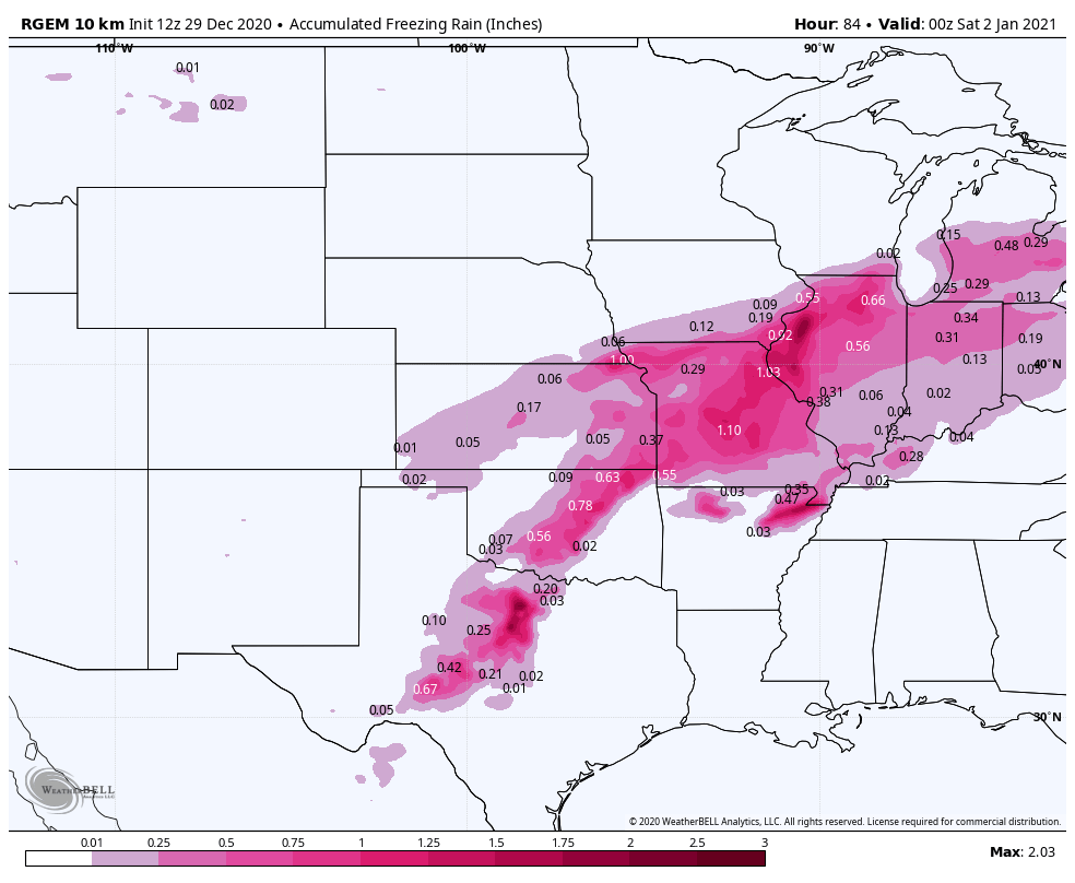
rockchalk83 replied to JoMo's topic in Central/Western States
12z RDPS continues the theme of an ice storm from central OK through Missouri. Quarter to two-thirds of an inch of ice possible if that run verifies.
-
MO/KS/AR/OK 2020-2021 "Winter" Discussion
rockchalk83 replied to JoMo's topic in Central/Western States
Don't say that. Some places in southwest Kansas have had 30 inches of snow already this year. Wichita has had about 2 inches. -
MO/KS/AR/OK 2020-2021 "Winter" Discussion
rockchalk83 replied to JoMo's topic in Central/Western States
06z ECMWF, 06z ICON and 12z NAM have shifted west with the storm. Would like to have it be 2-4 degrees colder because if not, someone is going to get a helluva ice storm. Nice stripe of snow on the backside, too. -
MO/KS/AR/OK 2020-2021 "Winter" Discussion
rockchalk83 replied to JoMo's topic in Central/Western States
The 12z GEFS is not as warm for SW Mo as the op run. There is hope? -
MO/KS/AR/OK 2020-2021 "Winter" Discussion
rockchalk83 replied to JoMo's topic in Central/Western States
There was a discernable shift west in the 00z Euro & 06z GFS ensembles (stronger and somewhat slower), while the 06z Canadian Ensembles and the 12z NAM keep everything a little more open and to the east. The trend has been for stronger systems out here this year, I wonder if this will continue? -
MO/KS/AR/OK 2020-2021 "Winter" Discussion
rockchalk83 replied to JoMo's topic in Central/Western States
How far out does the off-hour ECMWF go out to? Would be interesting to see how this progressed. -
MO/KS/AR/OK 2020-2021 "Winter" Discussion
rockchalk83 replied to JoMo's topic in Central/Western States
Can we lock that in, please?!? -
MO/KS/AR/OK 2020-2021 "Winter" Discussion
rockchalk83 replied to JoMo's topic in Central/Western States
Good point. I didn't even think about where it would wrap up. The 12z Canadian shows a scenario where it wraps up across Oklahoma (500 mb level) and brings warm air into much of the region. Ice and snow storm for central and western Kansas. A small step toward the GFS, for sure. -
MO/KS/AR/OK 2020-2021 "Winter" Discussion
rockchalk83 replied to JoMo's topic in Central/Western States
In comparing the 12z GFS to the 00z Canadian and 00z Euro models, it appears the high pressure (modeled to be 1038-1042mb) is one of the keys to watch. All the models agree on a diffluent southwesterly flow with a lee-side low (modeled 999-1003 mb) developing, but, the degree of warmth is predicated on where the high pressure sets up and how strong that low is. If it's over MN, then we're looking at a big winter storm. Over southern Ontario, then we're looking at rain and storms. How have the models handled cold air masses so far this season? -
MO/KS/AR/OK 2020-2021 "Winter" Discussion
rockchalk83 replied to JoMo's topic in Central/Western States
Thank you! Its very interesting that a decent number of members plastered the region with big snows and the outliers were dry.