rockchalk83
-
Posts
375 -
Joined
-
Last visited
Content Type
Profiles
Blogs
Forums
American Weather
Media Demo
Store
Gallery
Everything posted by rockchalk83
-

MO/KS/AR/OK 2020-2021 "Winter" Discussion
rockchalk83 replied to JoMo's topic in Central/Western States
Caved for your area? It still looks decent for Oklahoma and Kansas. -
MO/KS/AR/OK 2020-2021 "Winter" Discussion
rockchalk83 replied to JoMo's topic in Central/Western States
It was just off shore this AM and made landfall in NW Washington earlier this afternoon...so it should be much better sampled tonight. -
MO/KS/AR/OK 2020-2021 "Winter" Discussion
rockchalk83 replied to JoMo's topic in Central/Western States
I’m puzzled by the discrepancy. My guess is that the NAM has a deeper wave, the GFS has a flatter solution. -
MO/KS/AR/OK 2020-2021 "Winter" Discussion
rockchalk83 replied to JoMo's topic in Central/Western States
Still lightly snowing here in Wichita. Should be over in the next hour or so, but we have not made it above zero yet. Headed to -15 overnight. Ouch. -
MO/KS/AR/OK 2020-2021 "Winter" Discussion
rockchalk83 replied to JoMo's topic in Central/Western States
New NAM 12km model rolling in...system looks to be a little stronger but neutral to a slight positive tilt. Higher totals for S KS. -
MO/KS/AR/OK 2020-2021 "Winter" Discussion
rockchalk83 replied to JoMo's topic in Central/Western States
It is past time to modernize the power grid. There is no way we should be faced with rolling blackouts in the middle of an historic cold outbreak. -
MO/KS/AR/OK 2020-2021 "Winter" Discussion
rockchalk83 replied to JoMo's topic in Central/Western States
Picked up another half-inch in the last six hours. Officially 4" on the ground here in Wichita. -
MO/KS/AR/OK 2020-2021 "Winter" Discussion
rockchalk83 replied to JoMo's topic in Central/Western States
I have about 4.5" here in Wichita. Measured it about 8 times. In the words of Bill Belichick, "We're on to late Tuesday..." -
MO/KS/AR/OK 2020-2021 "Winter" Discussion
rockchalk83 replied to JoMo's topic in Central/Western States
Same here. Will definitely be giving it credence for the mid-week stuff, too. -
MO/KS/AR/OK 2020-2021 "Winter" Discussion
rockchalk83 replied to JoMo's topic in Central/Western States
I'm quite surprised to see the HRRR doing this poorly. The RAP has also done pretty well with this system, too. -
MO/KS/AR/OK 2020-2021 "Winter" Discussion
rockchalk83 replied to JoMo's topic in Central/Western States
It came north some. -
MO/KS/AR/OK 2020-2021 "Winter" Discussion
rockchalk83 replied to JoMo's topic in Central/Western States
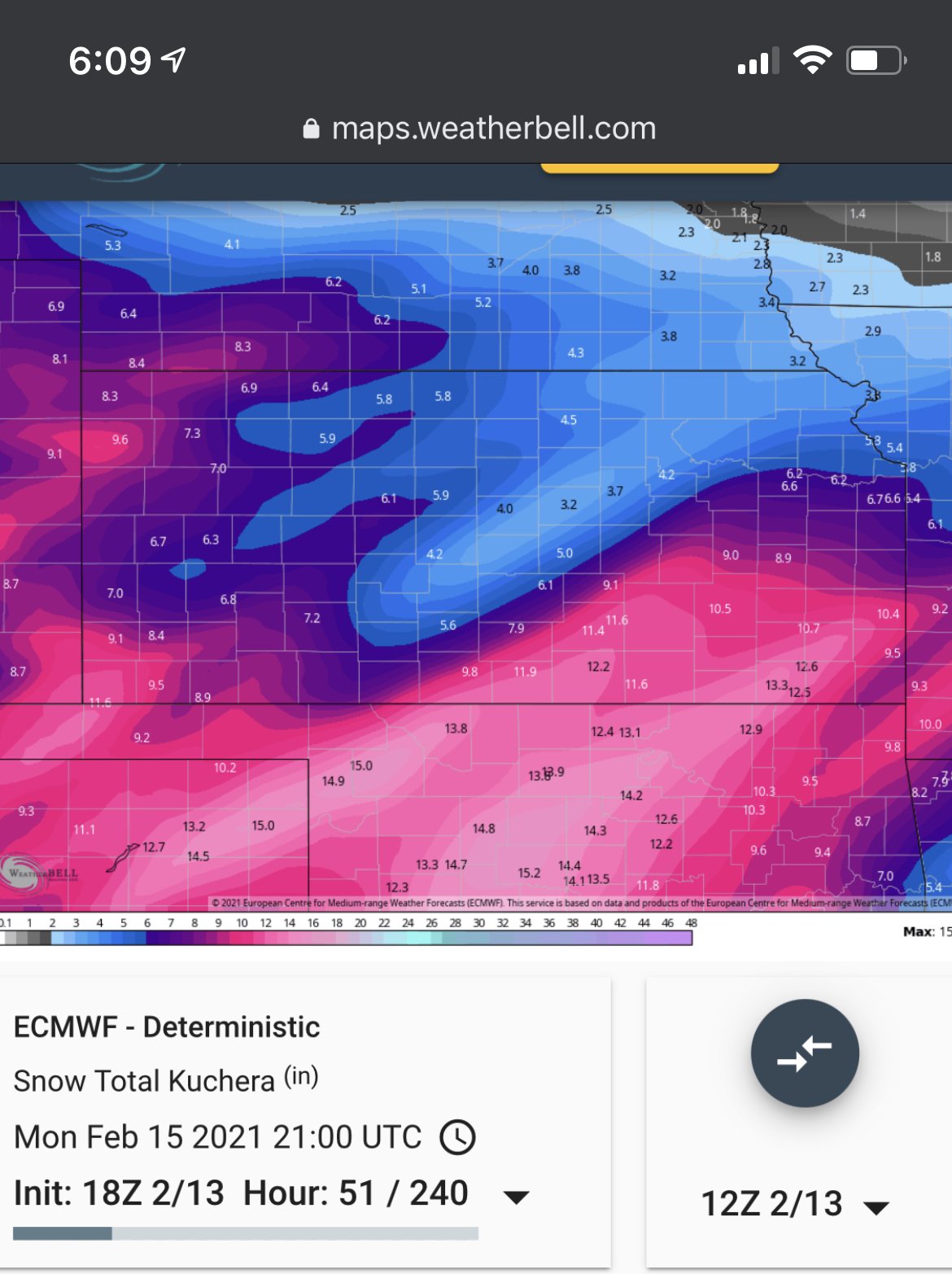
18z Euro, for kicks and giggles (KS Centered)
-
MO/KS/AR/OK 2020-2021 "Winter" Discussion
rockchalk83 replied to JoMo's topic in Central/Western States
Why do you think that is? Also noticed the RAP doing that, too, bringing widespread 4-8" across KS. -
MO/KS/AR/OK 2020-2021 "Winter" Discussion
rockchalk83 replied to JoMo's topic in Central/Western States
You and me both, man! -
MO/KS/AR/OK 2020-2021 "Winter" Discussion
rockchalk83 replied to JoMo's topic in Central/Western States
18z NAM digs the system in the southwest currently all the way to near Monterrey, MX before turning east. The system behind it is a little deeper (neutral tilt) but also farther south. It has the band the MO/NE OK crowd is keying on, but about 150 miles west over SC KS...develops it in the warm air advection regime as the trof comes out. As JoMo said, it really wraps up on Monday. If that trend continues, look for it to waffle back northwest. -
MO/KS/AR/OK 2020-2021 "Winter" Discussion
rockchalk83 replied to JoMo's topic in Central/Western States
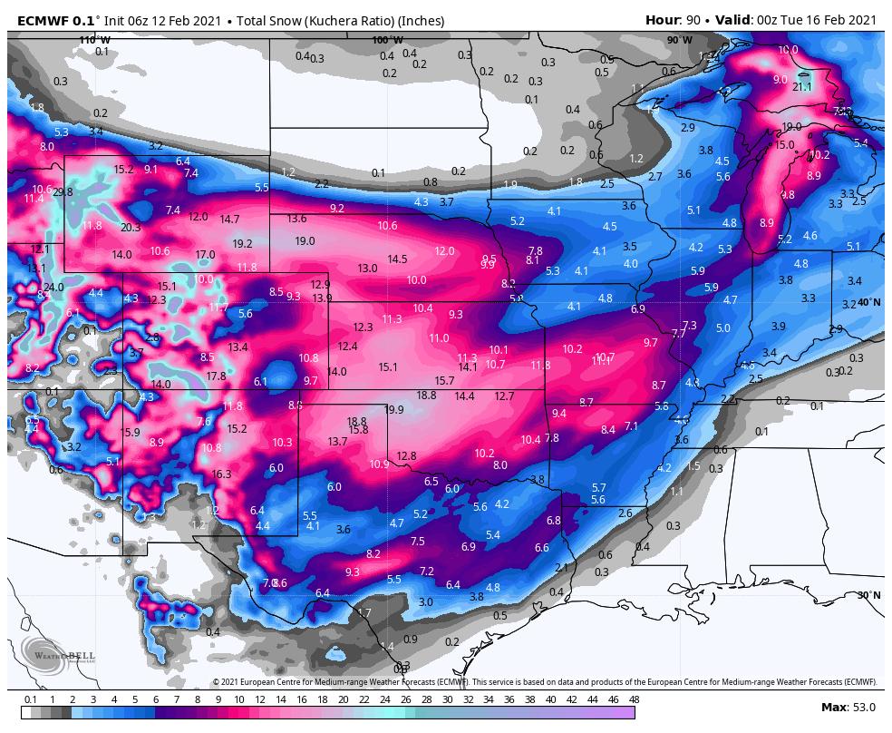
25-30:1, it looks like. I wonder if Euro drags down some very cold air from aloft, which may be the reason for the enhanced SLR's. -
MO/KS/AR/OK 2020-2021 "Winter" Discussion
rockchalk83 replied to JoMo's topic in Central/Western States
From analyzing the GFS & Euro runs, that the GFS had a slightly weaker 500 mb low, while the Euro had a stronger system and was more closed off from landfall through the Ohio Valley. Will have to see if the trend holds true in later model runs or if there's a correction back to stronger. -
MO/KS/AR/OK 2020-2021 "Winter" Discussion
rockchalk83 replied to JoMo's topic in Central/Western States
Right there with you, man. Hoping for a good one. -
MO/KS/AR/OK 2020-2021 "Winter" Discussion
rockchalk83 replied to JoMo's topic in Central/Western States
Suddenly, a little nervous for this Euro run. Gotta admit. -
MO/KS/AR/OK 2020-2021 "Winter" Discussion
rockchalk83 replied to JoMo's topic in Central/Western States
What is the reason for the ensembles & latest op GFS run to trend drier? Is it the system from overnight tonight digging farther south, meaning a subtle shift south in the track, or is it the wave being more open/quicker? -
MO/KS/AR/OK 2020-2021 "Winter" Discussion
rockchalk83 replied to JoMo's topic in Central/Western States
I got the sense from looking at the ICON that it was keying in on the next system for Wed/Thu and created the most snow out of that. The difference that the 06z Euro & GFS have over the other short term models is that they have the trof slightly deeper and not as progressive, thus higher snowfall totals. Not sure whether to buy the Sonic the Hedgehog nature of the system or keep with persistence and go with the slower motion. I do agree with you, JoMo, that with this persistent light snow done with very little lift, has to play into our advantage over the weekend. -
MO/KS/AR/OK 2020-2021 "Winter" Discussion
rockchalk83 replied to JoMo's topic in Central/Western States
Biggest hit in at least a day worth of Euro runs...it has been trending up recently (at least in Kansas), maybe it has an idea finally of what's going on? Stay tuned...: EDIT: This is exclusively the first storm.
-
MO/KS/AR/OK 2020-2021 "Winter" Discussion
rockchalk83 replied to JoMo's topic in Central/Western States
The NAM and Euro have been hot garbage during this cold outbreak. Consistently 2-5 degrees too warm at any daypart w/in 72 hours and slow to catch up to the lower temps. -
MO/KS/AR/OK 2020-2021 "Winter" Discussion
rockchalk83 replied to JoMo's topic in Central/Western States
I noticed that, too. Seems squirrely to me. Also not buying the hard stop to the precip shield in E KS and MO. Think we'll see widespread QPF south of I-70 of greater than .4". -
MO/KS/AR/OK 2020-2021 "Winter" Discussion
rockchalk83 replied to JoMo's topic in Central/Western States
If I’m in S KS, if the trend today has not been all the best. A deeper, more south-trending storm system. We’ll have to see how deep tomorrow’s system digs to get a better handle on the weekend system. 8 of the 20 members in the 18z GFS Ensembles have less than 6 inches of accumulation thru 96 hours. On to the 00z suite.