

rockchalk83
-
Posts
375 -
Joined
-
Last visited
About rockchalk83

-

MO/KS/AR/OK 2024-2025 Winter Discussion
rockchalk83 replied to JoMo's topic in Central/Western States
I don’t think solar radiation had an issue with the snow flakes being small. I think it was so cold & dry in the snow growth zone it didn’t take much moisture to make those flakes. Hence, why they were so small. The small flakes could have led to some minor compaction, but that’s a process generally left for heavy, wet snow. -
MO/KS/AR/OK 2024-2025 Winter Discussion
rockchalk83 replied to JoMo's topic in Central/Western States
Dry air at 2,000 feet, and then at 12-14,000 ft killed the forecast in all likelihood. It didn't show up until you looked at the Euro runs yesterday and then the HRRR runs last night. Hidden in plain sight. But in all reality, it is very hard to get a >10" snowstorm out in this part of the country. The numbers being put on the street by models and others yesterday were surreal. In some way, it felt like a bad troll job. The synoptic setup of having arctic air come in ~12 hours before the event will always cause issues because the initial cold air advection in those airmasses can be quite powerful. Having done some case study work on this, most big snowfalls in this part of the country have had 24-48 hours of cold in place before the snow begins. -
MO/KS/AR/OK 2024-2025 Winter Discussion
rockchalk83 replied to JoMo's topic in Central/Western States
Looks like the 3 KM NAM went back north just a smidge. Still widespread 8-12" for most here: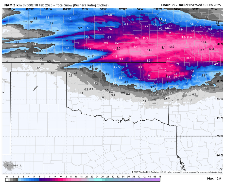
-
MO/KS/AR/OK 2024-2025 Winter Discussion
rockchalk83 replied to JoMo's topic in Central/Western States
06z Euro keeps this trend up. It feels like a fast outlier compared to the short-term, high-res modeling. Will be interesting to see if there is a shift in trends as we go through the day. -
MO/KS/AR/OK 2024-2025 Winter Discussion
rockchalk83 replied to JoMo's topic in Central/Western States
One trend to watch is the positioning of the 850 front. The HRRR hints at it becoming more NE-SW oriented due to warm air advection with the low to the southwest, as opposed to W-E as some of the other models have it. The result becomes a big hit in S KS/NC OK, with more sleet & freezing rain in NE OK & SW MO, before eventually changing to snow. -
MO/KS/AR/OK 2024-2025 Winter Discussion
rockchalk83 replied to JoMo's topic in Central/Western States
Wichita issued a winter storm watch, too, and have “moderate to heavy accumulations of greater than 4 inches” in the watch text. Wouldn’t shock me to see that watch get pulled farther west and north. -
MO/KS/AR/OK 2024-2025 Winter Discussion
rockchalk83 replied to JoMo's topic in Central/Western States
That's the 850 & 700 mb fronts stalling in response to the low pressure developing to the west. -
MO/KS/AR/OK 2024-2025 Winter Discussion
rockchalk83 replied to JoMo's topic in Central/Western States
Will you post the 12 Z models? -
MO/KS/AR/OK 2024-2025 Winter Discussion
rockchalk83 replied to JoMo's topic in Central/Western States
The first of two winter storms will impact the region Monday night into midday Tuesday, and doesn't really look all that impactful for the region. The Euro paints an icing event for the I-44 corridor (image below), with heavy snow across northern Oklahoma and much of Kansas. If this is true, the second storm Tuesday night and Wednesday will cause significant travel issues for the region.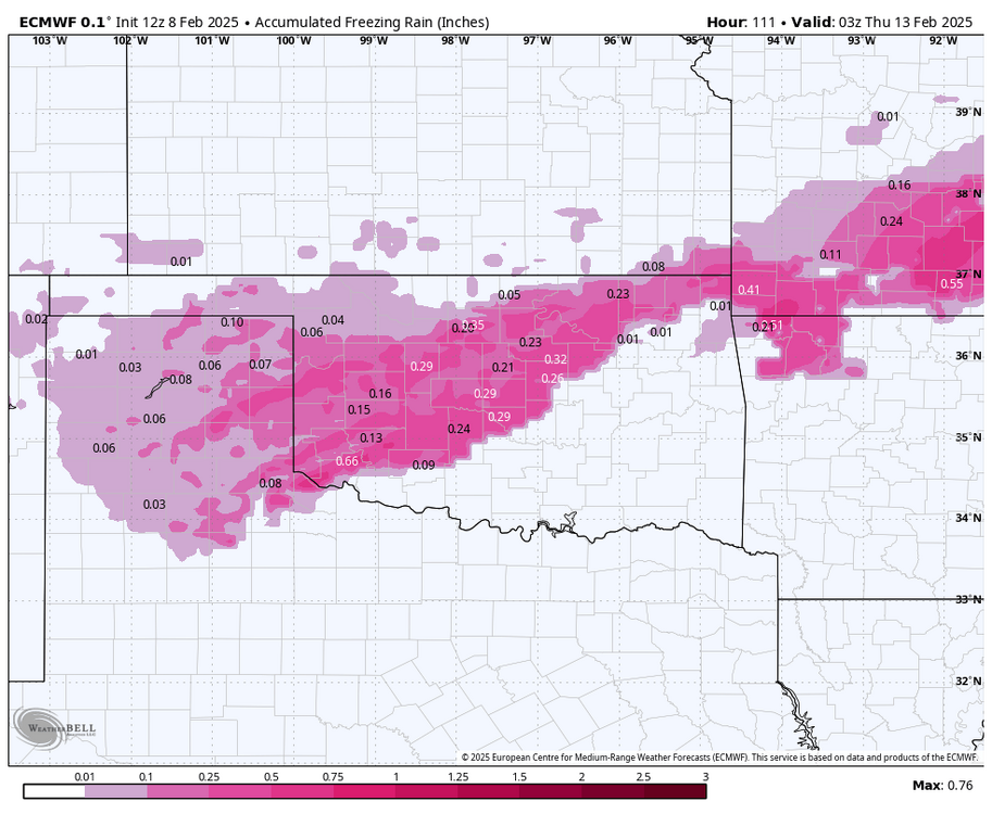
-
MO/KS/AR/OK 2024-2025 Winter Discussion
rockchalk83 replied to JoMo's topic in Central/Western States
Yeah, we did. The interesting thing about this system is that the upper level feature is in a more closed low setup, which leads to slower progression and more lift for snow. Already 4-6" across the Wichita metro, with probably another 6-8 hours of snow to go. Someone is getting 10+" in south-central Kansas. -
MO/KS/AR/OK 2024-2025 Winter Discussion
rockchalk83 replied to JoMo's topic in Central/Western States
Good luck everyone! Snow just beginning to fall here in Wichita, looking at 3 to 5 inches before it’s all over. -
MO/KS/AR/OK 2023-2024 Winter Discussion
rockchalk83 replied to JoMo's topic in Central/Western States
A little concerned the ensembles remain drier than the operational runs and we see a drying trend in the operational models over the next couple of days. Especially with the volume of cold air coming. Either way, dangerous weather is coming with the combo of dangerous cold and atleast some snow. -
MO/KS/AR/OK 2023-2024 Winter Discussion
rockchalk83 replied to JoMo's topic in Central/Western States
Rain is changing to snow in Newton and Goddard, won’t be long for us. Gonna be an interesting night. -
MO/KS/AR/OK 2023-2024 Winter Discussion
rockchalk83 replied to JoMo's topic in Central/Western States
Meanwhile, the 850 mb low for this current storm system was analyzed 100 miles farther south than modeled. High-res models have been trending up on this current threat this morning. But farther west from where @RocketWXand I are...it's a full scale blizzard in Western Kansas. -
MO/KS/AR/OK 2023-2024 Winter Discussion
rockchalk83 replied to JoMo's topic in Central/Western States
Do you think the MON/TUE system will shift south? In reading the AFDs from DDC and ICT, their mets seem to think so.


