
Southern stream
-
Posts
44 -
Joined
-
Last visited
Content Type
Profiles
Blogs
Forums
American Weather
Media Demo
Store
Gallery
Everything posted by Southern stream
-
March 17-18 Severe Weather Event
Southern stream replied to DanLarsen34's topic in Southeastern States
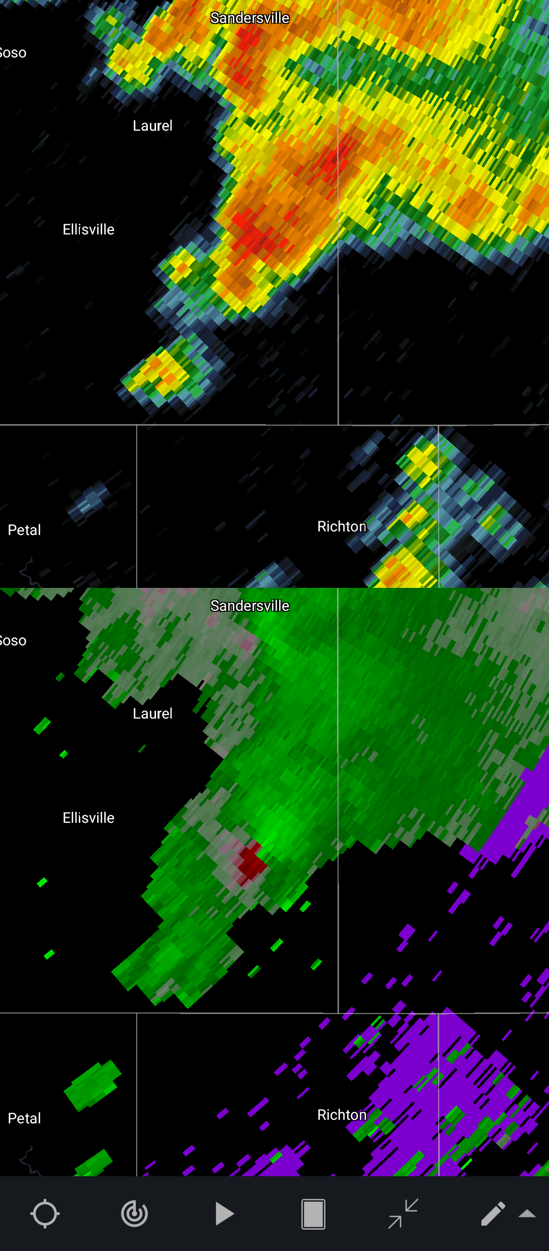
Impressive, SE MS rapidly becoming active.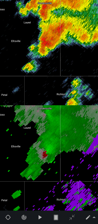
-
March 17-18 Severe Weather Event
Southern stream replied to DanLarsen34's topic in Southeastern States
Agree! I would honestly say throwing out predicted numbers and intensities is altogether, irresponsible. Just the fact that alot of this event will occur in the evening/overnight makes it a very dangerous situation. -
Spring 2021 Medium/Long Range Discussion
Southern stream replied to madwx's topic in Lakes/Ohio Valley
Although this is no promise of active weather, definitely a step in the right direction.
-
Spring 2021 Medium/Long Range Discussion
Southern stream replied to madwx's topic in Lakes/Ohio Valley
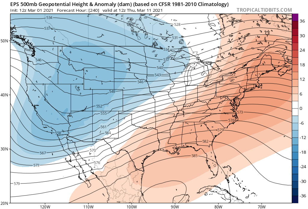
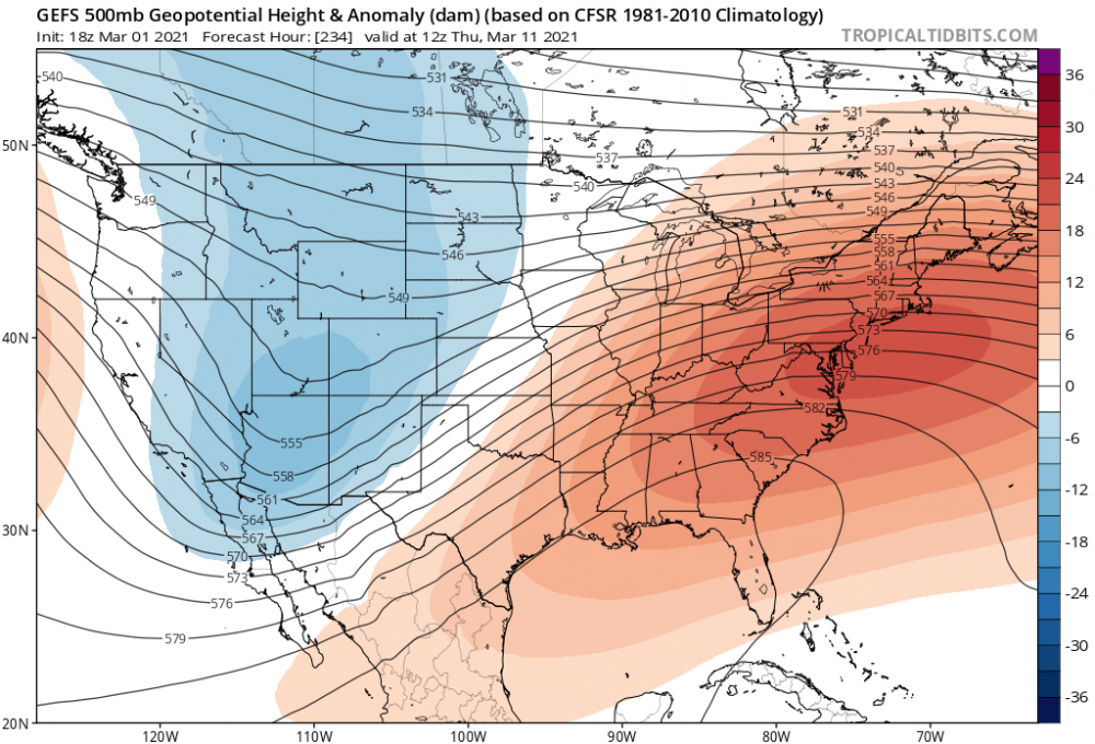
With all of the historic flooding around here, many of us need a break for the next several days so no complaints here. Height anomalies look encouraging toward mid March. More of a typical trough west/ridge east scenario. Jet pattern really amplifies around that timeframe. -
PAH and LMK will more than likely up areas to warning headlines by morning, based on the 0z runs a good (maybe even conservative) 6-10"+ swath looking probable considering the ratios we will be dealing with in an arctic airmass. Hopefully you peeps up to my north/northwest can get in on the action too.
-
Okay, I noticed there is a relative lack of southern/eastern sub-forum members posting on this event so I decided to hop in. Long time lurker of 6 years, from NW KY. It's been quite awhile since I have seen this much consensus on a 6"+ storm for the Lower OH Valley. Excited to say the least! Was somewhat questioning last night's 0z GFS sporting the progressive bias, but pretty much all late evening runs have corrected back to the west. Thankfully this go around we won't have any icing issues in my vicinity, received almost .50 of that from the ice storm a few days ago.
-
2019 Short/Medium Range Severe Weather Thread
Southern stream replied to snowlover2's topic in Lakes/Ohio Valley
Slight risk has been added for Wednesday. Looks to me like mainly a Damaging wind threat. Haven't looked in detail at soundings this morning. The NAM last night (at that point the outlier) was showing a decent LL veering, but the rest of the column was pretty well unidirectional. Hence I think even with that solution, the main tor threat would be brief spinups along a line. Atleast in my immediate area, models are generally in good agreement, bringing a complex through mid/late evening..png.9f871bf7b1c3b73ab1e43c26b79ee541.png)
-
2019 Short/Medium Range Severe Weather Thread
Southern stream replied to snowlover2's topic in Lakes/Ohio Valley
Climatology leans toward late May as getting toward our last chances to get a significant event in the Lower OH valley (South IN/South IL/West KY) tornado wise, minus maybe the early June of '90 outbreak. May 30, 2004 and May 25, 2011 are the last major late May events I can remember but correct me if wrong please, and both coincidentally were High risks. Still plenty of wind events through June and July on average but with the main jet energy shifting north toward the northern plains and upper midwest, thats usually about all we tend to get in those months. We have had setup after setup this season that was very favorable on a large scale for some big things, but instability and mesoscale issues have constantly dampened them to a conditional threat that never materializes. This upcoming pattern looks like our best shot so far this spring at something big, and IMO climatologically late May is getting toward our last bit of tornado season down this way.