

HeadInTheClouds
-
Posts
1,663 -
Joined
-
Last visited
Content Type
Profiles
Blogs
Forums
American Weather
Media Demo
Store
Gallery
Everything posted by HeadInTheClouds
-
Where do I sign?
-

January 2020 General Discussions & Observations Thread
HeadInTheClouds replied to Rtd208's topic in New York City Metro
And 18z could have it something completely different. -
It's a lock.
-
You are still in the game, yes. Read the NWS Albany forecaster's discussion. They feel precip type will alternate between wet snow and rain depending on elevation and precip intensity.
-
200 ft.
-
Yes they do and you may do ok as well being further west with some elevation. I may be too far east for any significant snows from this one even though I'm north of 84. We shall see.
-
12z runs of GFS and CMC were not good for snow in the area, even away from NYC metro. Low is just too far north and west.
-
This system needs to be watched by anybody 50+ miles N and W of NYC. I think the coast is toast.
-
That could be a really good spot for this one, west of NYC Metro and with some elevation.
-
NWS Albany talking about this as a system to watch. Temps are marginal at best especially for coast but to early to say it's not possible. Latest GFS similar CMC with decent snows north of city. I will definitely be watching this.
-
Wintry mix potential weekend of Jan 18-19, 2020
HeadInTheClouds replied to wdrag's topic in New York City Metro
Finished with 4 inches, 17.5 for the season. -
Wintry mix potential weekend of Jan 18-19, 2020
HeadInTheClouds replied to wdrag's topic in New York City Metro
23 with moderate snow still. -
Wintry mix potential weekend of Jan 18-19, 2020
HeadInTheClouds replied to wdrag's topic in New York City Metro
I haven't seen him post all day. He must be out sleigh riding in the rain. -
Wintry mix potential weekend of Jan 18-19, 2020
HeadInTheClouds replied to wdrag's topic in New York City Metro
Alot of places will wind up with 3, close enough. -
Wintry mix potential weekend of Jan 18-19, 2020
HeadInTheClouds replied to wdrag's topic in New York City Metro
22 with moderate snow. 2.5 OTG. -
Wintry mix potential weekend of Jan 18-19, 2020
HeadInTheClouds replied to wdrag's topic in New York City Metro
19 with moderate snow. -
Wintry mix potential weekend of Jan 18-19, 2020
HeadInTheClouds replied to wdrag's topic in New York City Metro
It started snowing up here 20 minutes ago, now a steady light snow with a dusting, temp 20. -
Wintry mix potential weekend of Jan 18-19, 2020
HeadInTheClouds replied to wdrag's topic in New York City Metro
Just overcast here in mid hudson valley. 21/3. -
January 2020 General Discussions & Observations Thread
HeadInTheClouds replied to Rtd208's topic in New York City Metro
18/2, feels like snow. -
Wintry mix potential weekend of Jan 18-19, 2020
HeadInTheClouds replied to wdrag's topic in New York City Metro
For you in Rockland probably between 2 and 3pm. -
Wintry mix potential weekend of Jan 18-19, 2020
HeadInTheClouds replied to wdrag's topic in New York City Metro
You aint kidding. 18 here right now with a forecast low of 7 tonight and high of 28 tomorrow. -
Wintry mix potential weekend of Jan 18-19, 2020
HeadInTheClouds replied to wdrag's topic in New York City Metro
.thumb.png.2efb2a5eafbccddb8dcce1fef581f8ba.png)
-
Wintry mix potential weekend of Jan 18-19, 2020
HeadInTheClouds replied to wdrag's topic in New York City Metro
Yes, and I think 3-4 inches is still a good call for us in Mid HV. I would be surprised with anything more than that. -
Wintry mix potential weekend of Jan 18-19, 2020
HeadInTheClouds replied to wdrag's topic in New York City Metro
-
Wintry mix potential weekend of Jan 18-19, 2020
HeadInTheClouds replied to wdrag's topic in New York City Metro
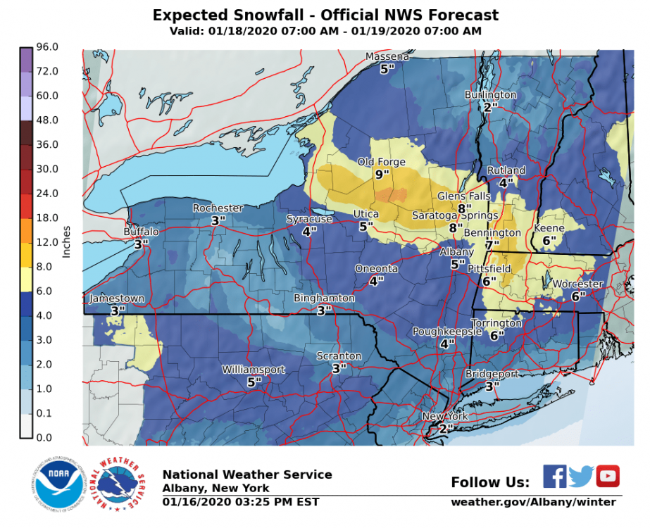
Latest discussion from NWS Albany below. Looks like 3-5 for most of lower and mid HV. North of I90 get 6+ A fast moving storm with favorable jet dynamics will bring a widespread moderate to heavy snowfall to the region. A cold airmass will be place across the region ahead of this storm. There will be impressive insentropic lift with strong frontogenetical forcing. CSTAR research indicates banding will be possible. Laterally translately bands occur with strong warm air advection and the low approaching from the west. Overrunning warm air advection snow will quickly spread across the area early Saturday afternoon. Once it starts expect it come down heavy with snowfall rates of 1 to 2 inches an hour. The bulk of the snow is expected to fall between noon and midnight. The highest snowfall amounts are expected across the southern Adirondacks, lake George Saratoga Region, Berkshires and southern Vermont where 7+ inches are expected. Secondary development is not expected to occur until Saturday night and off along the northern New England coast. So our snow will come from the primary low and with the southerly flow ahead of it some mixing with rain possible into the mid Hudson Valley and northwestern Connecticut late Saturday evening however the dry slot should also be moving in at the time.


.png.a80929c70faf247c77488283e53d9f4a.png)
