

HeadInTheClouds
-
Posts
1,663 -
Joined
-
Last visited
Content Type
Profiles
Blogs
Forums
American Weather
Media Demo
Store
Gallery
Everything posted by HeadInTheClouds
-

February 24/25 Potential Winter Storm
HeadInTheClouds replied to mikem81's topic in New York City Metro
The soundings for the CMC are 6 hour increments. The CMC which is the warmest of the models still gives a couple inches well south of 84. How many times have we seen precip come in faster than modeled and a cold arctic high underestimated by models? How many? The moderate/heavy snows will likely be north of 84 but it's very plausible to see snow south of 84. Look at the 12z's, every model gives anywhere from 1-4 north of NYC up to 84. -
February 24/25 Potential Winter Storm
HeadInTheClouds replied to mikem81's topic in New York City Metro
I’m 20 miles north of 84 and the warm cmc gives me 6 inches. I’m not buying the sleetfest for everybody. Places north of NYC and south of 84 will see some snow before changeover. -
February 24/25 Potential Winter Storm
HeadInTheClouds replied to mikem81's topic in New York City Metro
.thumb.png.c5f5fd2f6490a4b218c410d7e4d894fd.png)
-
February 24/25 Potential Winter Storm
HeadInTheClouds replied to mikem81's topic in New York City Metro
Yup. CMC also had a lot of sleet for NYC. -
February 24/25 Potential Winter Storm
HeadInTheClouds replied to mikem81's topic in New York City Metro
UKIE.thumb.png.064bf2dfbff95eb19ce592f6a90853e9.png)
-
February 24/25 Potential Winter Storm
HeadInTheClouds replied to mikem81's topic in New York City Metro
.thumb.png.091054f6963e2c4ee0962203437c5e87.png)
-
February 24/25 Potential Winter Storm
HeadInTheClouds replied to mikem81's topic in New York City Metro
.thumb.png.22df7c99cf46b85c713a2901d5a04cfe.png)
-
Sure it is.
-
February 24/25 Potential Winter Storm
HeadInTheClouds replied to mikem81's topic in New York City Metro
QPF by me went from .74 12z to 1.15 on 18z and snowfall increased from 7 to 12. Who knows? It looked better at H5 for late next weekend also. -
February 24/25 Potential Winter Storm
HeadInTheClouds replied to mikem81's topic in New York City Metro
Yeah, temp wise its been slightly above normal to date(1.4 degrees) and that includes a very warm December, but we have been shafted with the snow amounts. -
February 24/25 Potential Winter Storm
HeadInTheClouds replied to mikem81's topic in New York City Metro
That map includes what falls Thursday night/Friday. Below is the map of what Euro shows for next Sunday. Right now it has zero support though.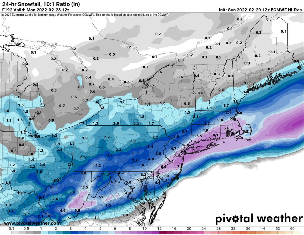
-
February 24/25 Potential Winter Storm
HeadInTheClouds replied to mikem81's topic in New York City Metro
Yes I know. I was just stating what the Euro was showing. -
February 24/25 Potential Winter Storm
HeadInTheClouds replied to mikem81's topic in New York City Metro
The thing that stands out on that for me is Albany's 17.2 VS 40.5 average. I'm in the same boat, only 15.5 so far and well below average. Hoping I can make some of that up in the next month. -
February 24/25 Potential Winter Storm
HeadInTheClouds replied to mikem81's topic in New York City Metro
It's just too early to say any thing is factual 4 days out. NYC could absolutely get a minor 1-2 inch front end dump of snow. -
February 24/25 Potential Winter Storm
HeadInTheClouds replied to mikem81's topic in New York City Metro
FWIW Euro also has something interesting next Sunday last few runs. -
February 24/25 Potential Winter Storm
HeadInTheClouds replied to mikem81's topic in New York City Metro
I'll take the 7 inches it gives me for sure but again way too early. Yesterday at 12z it was giving everybody .5-.6 liquid equivalent and today it's up to .8-1.0 for most. We track. -
February 24/25 Potential Winter Storm
HeadInTheClouds replied to mikem81's topic in New York City Metro
Agree. -
February 24/25 Potential Winter Storm
HeadInTheClouds replied to mikem81's topic in New York City Metro
They do favor northern areas. The higher your latitude the likely more snow and the changeover to sleet/ZR is delayed. -
February 24/25 Potential Winter Storm
HeadInTheClouds replied to mikem81's topic in New York City Metro
The models often tend to overestimate the mid level warming in these situations and it's still over 4 days away. NYC getting a few hours of front end snow is still plausible and those details we really don't know at this point. -
February 24/25 Potential Winter Storm
HeadInTheClouds replied to mikem81's topic in New York City Metro
I do hate it, especially for east coast storms, but I'm not throwing anything out 4.5 days away and act like nothing can change. I don't believe NYC is getting anywhere near the 6 inches it shows but some some front end snow is still in play. The Cmc tends to have a warm bias also. Still too early to be making definitive statements. That was my point. -
February 24/25 Potential Winter Storm
HeadInTheClouds replied to mikem81's topic in New York City Metro
You've seen enough? It's over 4 days away. The city could still see a few hours of snow at the beginning before changeover. GFS still gives metro a a good amount on front end. Not saying it's right but way too early to be turning off the lights on the front end snows. This has always been a system that the further north you are the more snow but NYC could definitely see some. -
February 24/25 Potential Winter Storm
HeadInTheClouds replied to mikem81's topic in New York City Metro
I think you are jumping the gun on that right now. Even the CMC keeps NYC metro mostly frozen. -
February 24/25 Potential Winter Storm
HeadInTheClouds replied to mikem81's topic in New York City Metro
Yup, I noticed that too, it's less amped and in and out pretty quickly. It does give most .5-.7 liquid equivalent though which for me is snow and sleet. Long way to go with this. -
February 24/25 Potential Winter Storm
HeadInTheClouds replied to mikem81's topic in New York City Metro
According to him every event is either a torch or a miss and yet it still snows. -
Not here unfortunately. Got 10 minutes of moderate/heavy snow and some gusty winds but nothing near whiteout. About 10 miles north of me got a heavy squall.


.png.cdf0e4bfc0d22a52e07fbfad9458e879.png)
.png.f063632976f099e50c771671e54767ad.png)
.png.b08237fd40fb96d684b27a4af25ecfe1.png)
.png.4e2f599bb37738491619377a2b32b3d0.png)


