Beachin
-
Posts
337 -
Joined
-
Last visited
Content Type
Profiles
Blogs
Forums
American Weather
Media Demo
Store
Gallery
Everything posted by Beachin
-
ITS STILL GOING OMG
-
Uh yeah you want convection you got it
-
There is some really deep moisture and vorticity advection aloft. Soundings are gonna show some definite instability aloft. Pretty good signal for strong banding and possible convection (Thundersnow)
-
Man this run is gonna be a beatdown lol Low is actually inland over NC headed towards EVA
-
I spy the NAM strengthening the 850mb jet Closed 145DM 850 low this run too. Everything is only getting better
-
LOL oh yeah big time NAM'ING incoming 500MB is the best its looked Yet!
-
This is gonna be a good run much more expansive precip into WV and a strong 850mb jet coming out of the south 14 still has a closed low signature Vort has responded much better. Consolidated and stronger
-
Long long range HRRR its still snowing so you can add to this im sure but yeah looks good HRRR KUCHERA Northern MD 5-8 Baltimore metro and DC metro 6-10 few 10+ pockets

-
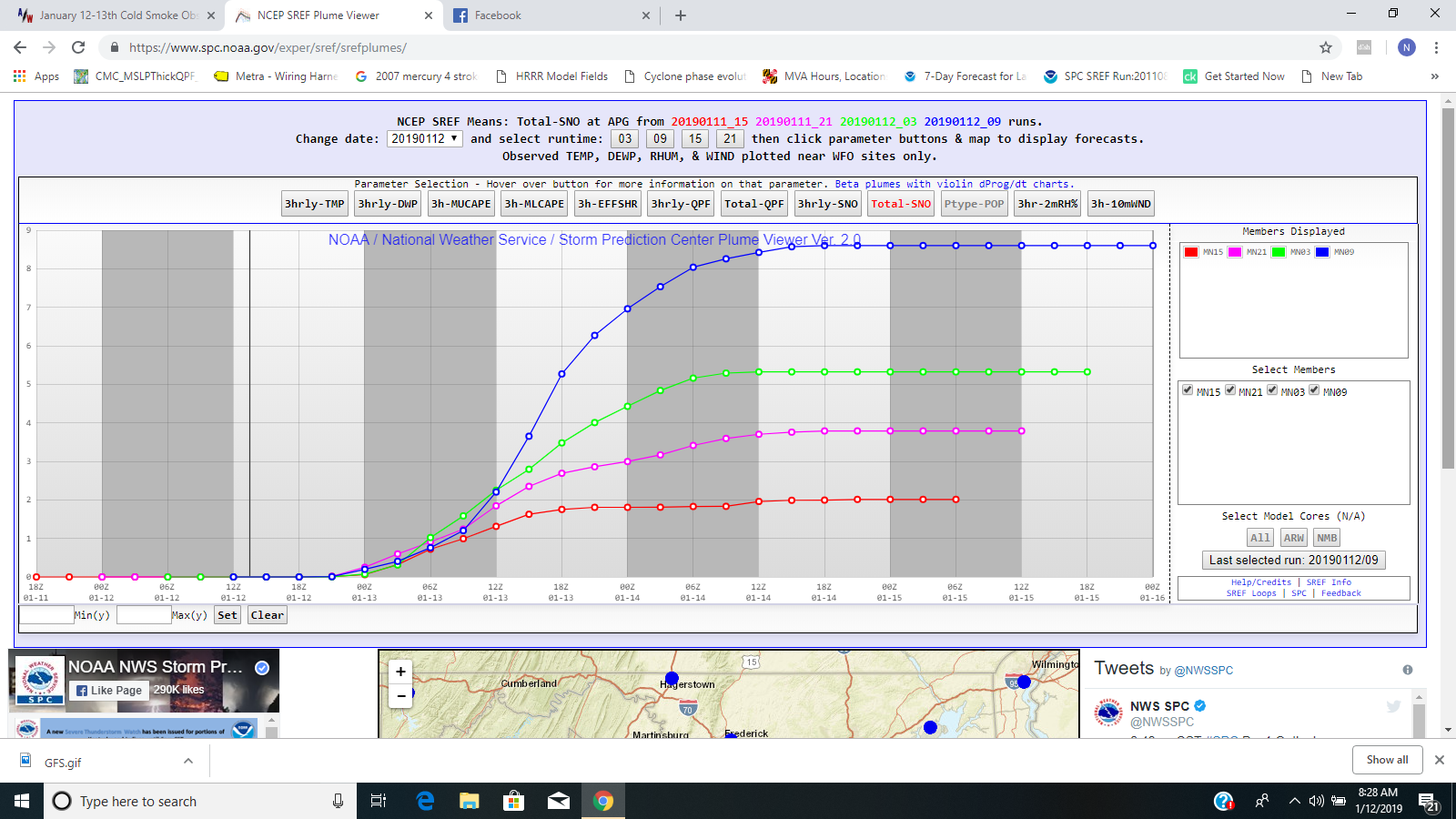
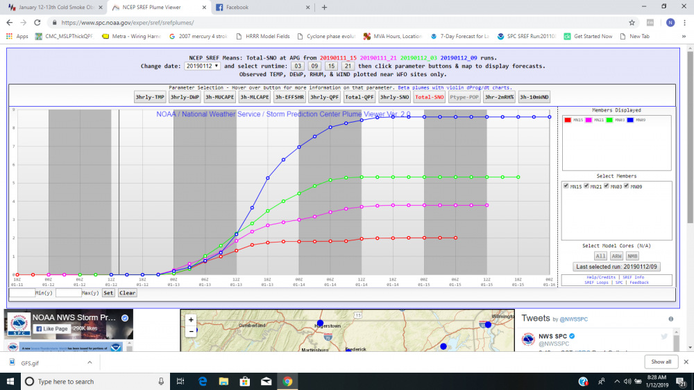
I know the NWS uses the SREF'S for trends very close to a event so this has to have them thinking for sure. IF 12z models nail WSW will fly for everyone im sure
-
You are reading it right and its very possible with what the trends have been
-
For you DC area
-
Huge jump on the SREF for northern MD no doubt
-
This is for Aberdeen Harford county. Look at the mean jump!!!!!
-
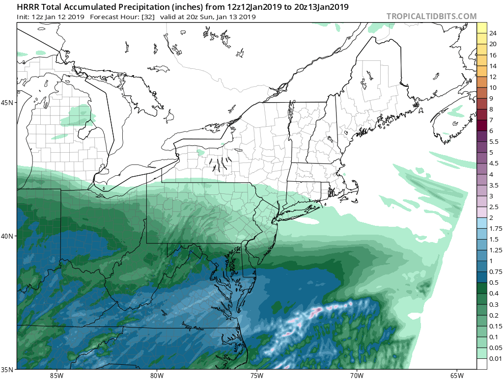
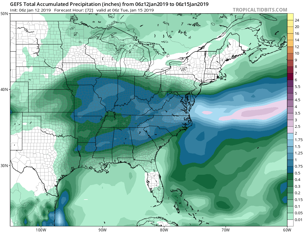
Not really going to need the coastal low to rack up good totals you can see the moisture transport pretty clear on radar and where the fetch runs into cold air its dumping snow. The vort has been continually looking better and better since 24 hours ago. I see a over performer.
-
Moisture transport from Gulf and Atlantic

-
That gulf tap does so much
-
Storm is continuing to trend north so I'm confident to let this out. (Northern area's may go higher later since ratios are much higher then southern areas) I think area wide masondixon south gets a WSW Northern MD 5-8 Baltimore metro 6-10 DC metro 6-10 (isolated 10+)
-
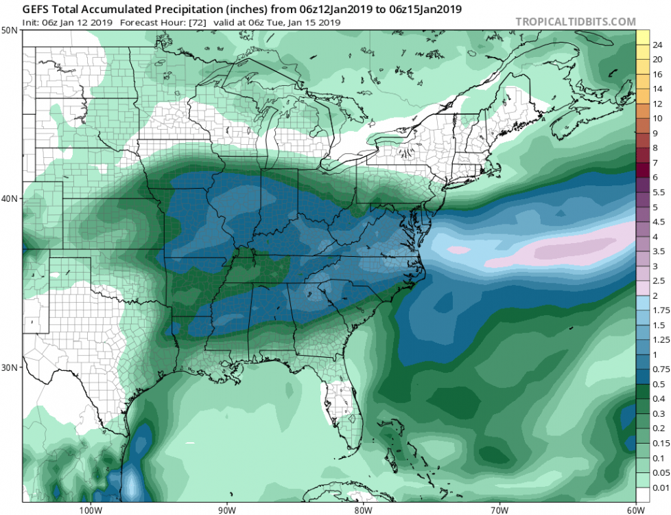
Fyiy the GEFS is north and still north then the OP. Don't think this north trend is over
-
Southern MD / Lower Eastern Shore weather discussion
Beachin replied to AnEndlessMaze's topic in Mid Atlantic
Salisbury becoming white already http://www.salisbury.edu/webcam/hh/ -
Southern MD / Lower Eastern Shore weather discussion
Beachin replied to AnEndlessMaze's topic in Mid Atlantic
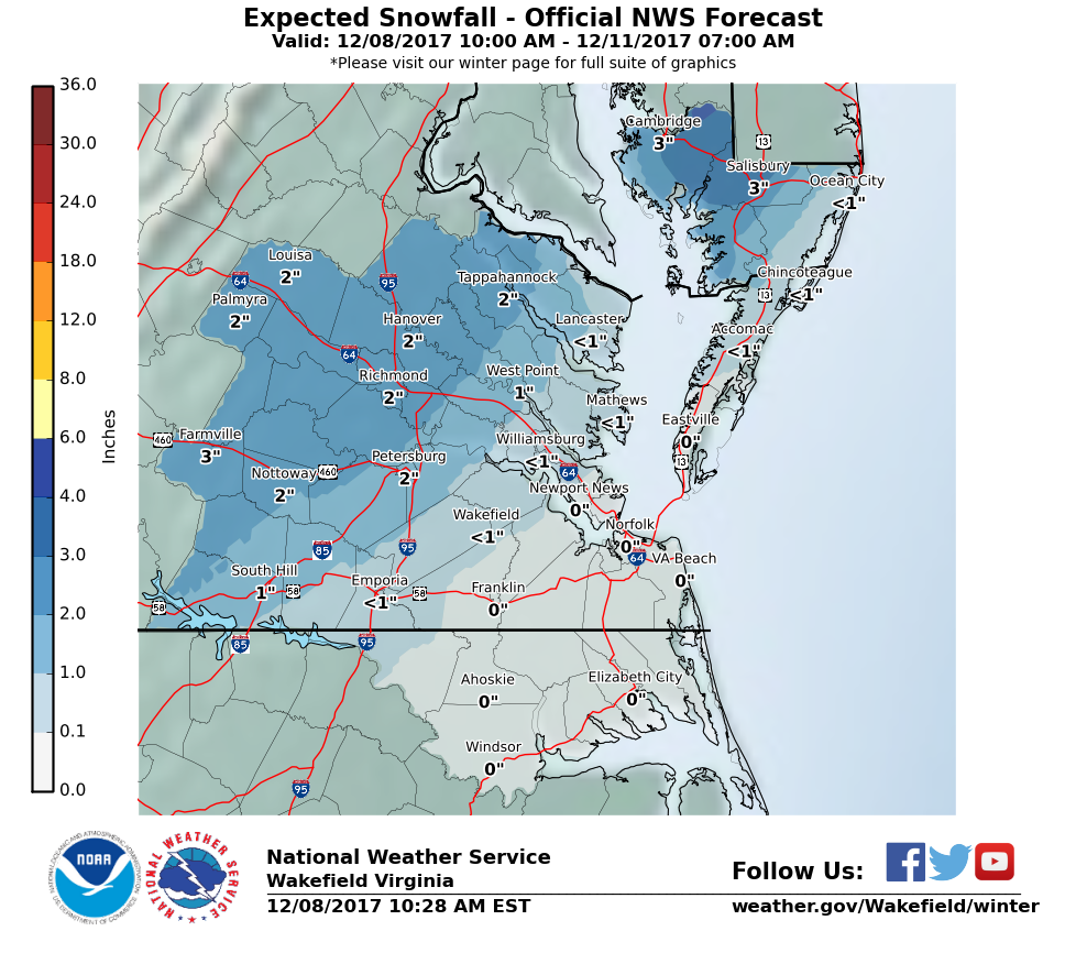
Winter Storm Warning URGENT - WINTER WEATHER MESSAGE National Weather Service Wakefield VA 309 PM EST Fri Dec 8 2017 MDZ021>023-090415- /O.UPG.KAKQ.WW.Y.0004.171209T0000Z-171210T0000Z/ /O.NEW.KAKQ.WS.W.0001.171209T0000Z-171210T0000Z/ Dorchester-Wicomico-Somerset- Including the cities of Cambridge, Salisbury, Crisfield, and Princess Anne 309 PM EST Fri Dec 8 2017 ...WINTER STORM WARNING IN EFFECT FROM 7 PM THIS EVENING TO 7 PM EST SATURDAY... * WHAT...Expect a mix of rain and snow to change to all snow this evening. Rain may briefly mix back in late tonight. Moderate to heavy wet snow expected. Plan on slippery travel conditions. Total wet snow accumulations of 4 to 6 inches are expected tonight into Saturday. Locally higher amounts are possible. * WHERE...Dorchester, Wicomico and Somerset Counties. * WHEN...From 7 PM this evening to 7 PM EST Saturday. * ADDITIONAL DETAILS...Be prepared for significant reductions in visibility at times. PRECAUTIONARY/PREPAREDNESS ACTIONS... A Winter Storm Warning for wet snow means severe winter weather conditions are expected. If you must travel, keep an extra flashlight, food and water in your vehicle in case of an emergency. The latest road conditions for the state you are calling from can be obtained by calling 5 1 1. -
Southern MD / Lower Eastern Shore weather discussion
Beachin replied to AnEndlessMaze's topic in Mid Atlantic
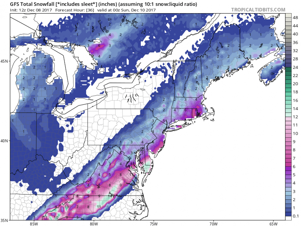
18Z HRRR 10:1 but you get the idea no worries about stickage tho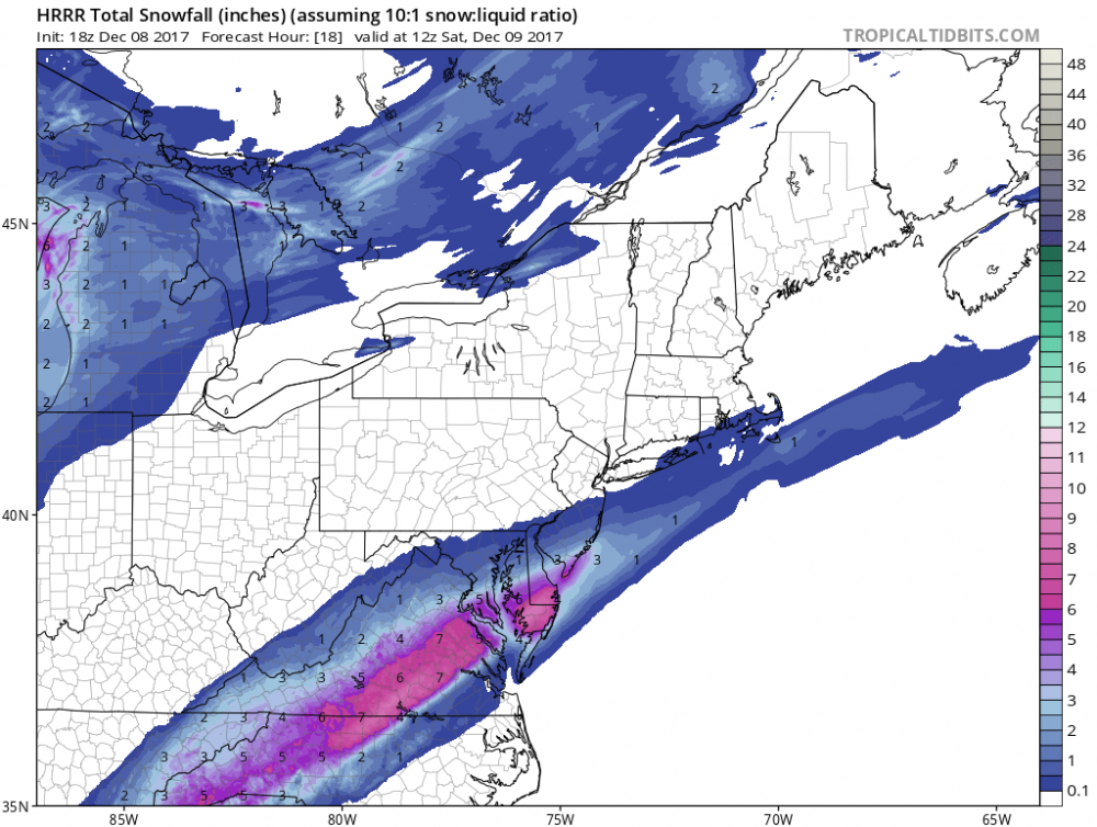
-
Southern MD / Lower Eastern Shore weather discussion
Beachin replied to AnEndlessMaze's topic in Mid Atlantic
Kuchera and remember snow is sticking in the south with temps near 80 a few days ago. really don't see it being a issue especially near Salisbury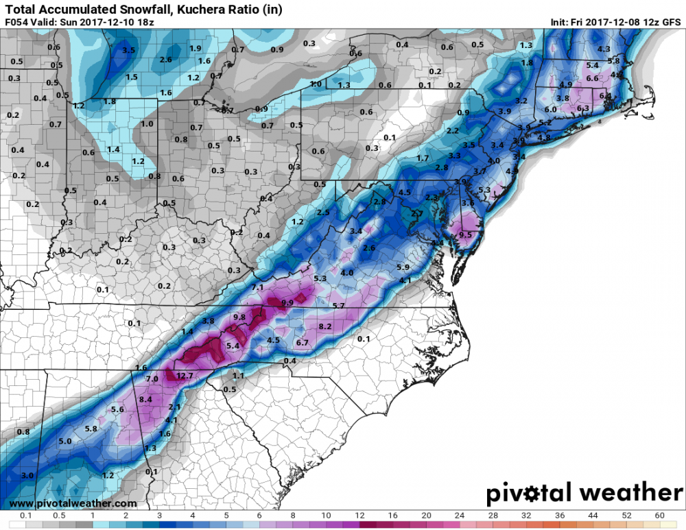
-
Southern MD / Lower Eastern Shore weather discussion
Beachin replied to AnEndlessMaze's topic in Mid Atlantic
AKQ is slowly pulling the trigger this was pre GFS so i expect some big changes come afternoon don't be surprised to see WSW up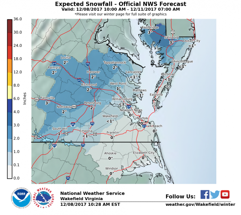
-
Southern MD / Lower Eastern Shore weather discussion
Beachin replied to AnEndlessMaze's topic in Mid Atlantic
Probably not going to happen but the shore will do well with this