TampaMan
-
Posts
599 -
Joined
-
Last visited
Content Type
Profiles
Blogs
Forums
American Weather
Media Demo
Store
Gallery
Everything posted by TampaMan
-

Richmond Metro/Hampton Roads Area Discussion
TampaMan replied to RIC Airport's topic in Mid Atlantic
Branches falling due to ice all around my neighborhood. -
Richmond Metro/Hampton Roads Area Discussion
TampaMan replied to RIC Airport's topic in Mid Atlantic
Yes, I took my break. I apologize for glooming and dooming yesterday. Weather made my emotions high. I apologize, all. Hopefully we can get some more on the back end. -
Richmond Metro/Hampton Roads Area Discussion
TampaMan replied to RIC Airport's topic in Mid Atlantic
Icy roads here in western Henrico. Slipped getting my work computer out of the car. Not sure what it’s like in the city. Expecting another 1-2 inches later on top of this will cause issues tomorrow morning due to the much colder air tonight. Heard a few transformers pop. -
Richmond Metro/Hampton Roads Area Discussion
TampaMan replied to RIC Airport's topic in Mid Atlantic
You mean speaking facts? Got it. -
Richmond Metro/Hampton Roads Area Discussion
TampaMan replied to RIC Airport's topic in Mid Atlantic
Even after the massive dry slot coming through? -
Richmond Metro/Hampton Roads Area Discussion
TampaMan replied to RIC Airport's topic in Mid Atlantic
dry slot approaching fast before precip even makes it to the ground. -
Richmond Metro/Hampton Roads Area Discussion
TampaMan replied to RIC Airport's topic in Mid Atlantic
DT has 6-8 for me. (Between shortpump and northern tuckahoe). I’d eat a brick if that happens lol. We really need this front end to start and end the Virga. FarmVille has precip now. -
Richmond Metro/Hampton Roads Area Discussion
TampaMan replied to RIC Airport's topic in Mid Atlantic
Backfill. But that’s where the warm air arises. Hopefully this Virga becomes precip asap. -
Richmond Metro/Hampton Roads Area Discussion
TampaMan replied to RIC Airport's topic in Mid Atlantic
If you don’t see every single model including the HRRR ticking north I can’t help you. The hype was built up yesterday and you and I both know it. Of course it’s frustrating when the same thing that always happens, happens again. Don’t get upset at someone for pointing out that this will be a bust. -
Richmond Metro/Hampton Roads Area Discussion
TampaMan replied to RIC Airport's topic in Mid Atlantic
I’m gonna take a break from this forum until tomorrow morning. I fear we’ve already busted before it begins. Not trying to be a gloomer it’s just what happens here with these types of systems. I’ll be happy with 1-2 with sleet on top at this point. Good luck everyone. Hope I’m wrong! -
Richmond Metro/Hampton Roads Area Discussion
TampaMan replied to RIC Airport's topic in Mid Atlantic
Models continuously moving north. Surprise surprise. -
Richmond Metro/Hampton Roads Area Discussion
TampaMan replied to RIC Airport's topic in Mid Atlantic
Is it possible to get snowfall totals through 5am tomorrow morning? -
Richmond Metro/Hampton Roads Area Discussion
TampaMan replied to RIC Airport's topic in Mid Atlantic
12z NAM does bring heavy snow in opposed to a dry slot in the 6z -
Richmond Metro/Hampton Roads Area Discussion
TampaMan replied to RIC Airport's topic in Mid Atlantic
I’d be shocked in ric and surrounding counties even got 1-2 as it stands. I don’t get paid as a meteorologist though. I’m not as optimistic today and there really is not a good reason to be. Warm air is arriving faster than the good 4-5 hours of snow we should’ve been getting according to every model other than the HRRR. -
Richmond Metro/Hampton Roads Area Discussion
TampaMan replied to RIC Airport's topic in Mid Atlantic
They’re calling for rain to start the storm then transition to snow for like 3 hours then all frozen pretty much until 9 am Monday then heavy rain from 9-12 and maybe back end snow at 4-8. -
Richmond Metro/Hampton Roads Area Discussion
TampaMan replied to RIC Airport's topic in Mid Atlantic
NBC12 just said on tv “I have doubts about decent snow around the city but prepare for the worst” not a good sign -
Richmond Metro/Hampton Roads Area Discussion
TampaMan replied to RIC Airport's topic in Mid Atlantic
Idk the models seem warmer and more North for any really good show to fall. Huge bust potential imo. -
Richmond Metro/Hampton Roads Area Discussion
TampaMan replied to RIC Airport's topic in Mid Atlantic
Tbh I think I have a permanent skepticism here unless it actually happens. Can’t blame me. The rug has been pulled too many times to count in the last 5 years. -
Richmond Metro/Hampton Roads Area Discussion
TampaMan replied to RIC Airport's topic in Mid Atlantic
If we get 3-6, 4-8, 8-12 (DT is delusional and will never hear the end of that map in my opinion) we all lucked out. Anything more than 3 is a gift of god. -
Richmond Metro/Hampton Roads Area Discussion
TampaMan replied to RIC Airport's topic in Mid Atlantic

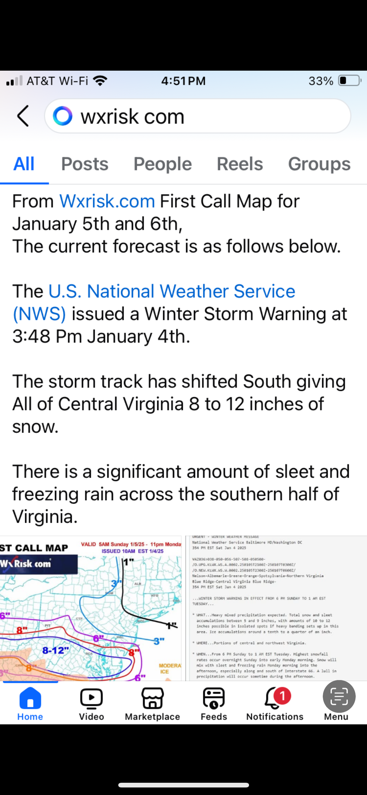
-
Richmond Metro/Hampton Roads Area Discussion
TampaMan replied to RIC Airport's topic in Mid Atlantic
Wow 4-6 from Wakefield is huge. Let’s go!!!!! -
Richmond Metro/Hampton Roads Area Discussion
TampaMan replied to RIC Airport's topic in Mid Atlantic
Wakefield sees something. Time to weenie -
Richmond Metro/Hampton Roads Area Discussion
TampaMan replied to RIC Airport's topic in Mid Atlantic
I don’t trust the NAM -
Richmond Metro/Hampton Roads Area Discussion
TampaMan replied to RIC Airport's topic in Mid Atlantic
5 hours of heavy snowfall. The front end likely being snow too. -
Richmond Metro/Hampton Roads Area Discussion
TampaMan replied to RIC Airport's topic in Mid Atlantic
Looks weaker but on the same track to me