

OrdIowPitMsp
-
Posts
2,299 -
Joined
-
Last visited
Content Type
Profiles
Blogs
Forums
American Weather
Media Demo
Store
Gallery
Everything posted by OrdIowPitMsp
-
Midnight high of 16 at MSP. Down to 7 at 6am. I’m surprised but the airport was able to hang onto our 1” snow depth through the 1 day warm up.
-

Winter 2024-25 Medium/Long Range Discussion
OrdIowPitMsp replied to michsnowfreak's topic in Lakes/Ohio Valley
I’ll take an April 2018 redux. -
Front has moved through. Down to 28 and falling fast after our high of 38 today. Backyard remains snow covered.
-
Winter 2024-25 Medium/Long Range Discussion
OrdIowPitMsp replied to michsnowfreak's topic in Lakes/Ohio Valley
5.5” from a juiced Clipper on December 19th. Pennies outside of that. Can’t get a system to come our way this winter. Only have to go to hour 330 on the GFS for substantial precipitation in my region. -
Temps overachieving here. Already up to 34F. The first above freezing temperature of 2025 in Minneapolis.
-
Winter 2024-25 Medium/Long Range Discussion
OrdIowPitMsp replied to michsnowfreak's topic in Lakes/Ohio Valley
All of us here know it’s coming too. Although snowfall has been paltry this winter locally there has been plenty of seasonable cold. The twin cities have held a 1-2” snow depth since last Thursday. -
0.1” a true dusting this evening.
-
-3F overnight low. Temps have shot up to 7 already. Unfortunately it looks like our meager snowpack will be mostly gone come Friday night.
-
-9F. Coldest morning this winter so far.
-
Noticing quite a bit of sublimation in the farm fields this morning here. The high SLR snow definitely plays a part.
-
MSP managed to drop to -1F before midnight so we recorded an official low below zero yesterday. It’s down to -3F this morning for our 3rd and 4th below zero lows of January.
-
We finished with 1.1” here which was enough to push MSP to an even 10” of snowfall on the season. CAA going strong, 5F currently with a stiff NW wind.
-
0.6” reported at 6am, with some light snow since. We had a long stretch of freezing drizzle overnight. Temps are beginning to crash after holding steady around 26-27F overnight. Today will be the classic midnight high.
-
Clipper #2 has brought a fresh dusting of pixie dust so far. Areas a couple counties north of me are going to do well but we should manage ~1” to boost the meager snowpack. Gradient of 2-3” down to 0.5” from north to south across Hennepin County according to the HRRR.
-
Tonight’s Clipper is trending towards a dusting for my backyard. Near miss to the north. Northern Minnesota is the place to be. GFS looking quite dry for most of the subforum.
-
24hr total of 0.8” at MSP. The high of 28 today is our warmest temp so far this month.
-
Technically it’s a different system, (Clipper) but the calendar date lines up so I’ll post here. Solid DAB+ in the Twin Cities. Evening commute was a total mess. Don’t know what MSP officially recorded but they did just report a 1” snowdepth at 6pm so at least 0.5”
-
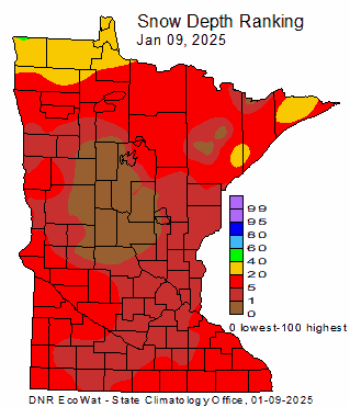
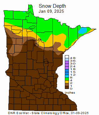
Hopefully these maps look different next week.
-
The Saturday/Sunday clipper is trending much better for Minnesota. Could squeeze out a few inches here but a lot of time for that to change.
-
Fall/Winter '24 Banter and Complaints Go Here
OrdIowPitMsp replied to IWXwx's topic in Lakes/Ohio Valley
I’ll take this pattern over firestorms. Must be acclimating because 5F doesn’t feel that bad this morning. -
We had some high clouds today. One of the more interesting thing to happen so far this month.
-
Winter 2024-25 Medium/Long Range Discussion
OrdIowPitMsp replied to michsnowfreak's topic in Lakes/Ohio Valley
All hail king euro. -
Winter 2024-25 Medium/Long Range Discussion
OrdIowPitMsp replied to michsnowfreak's topic in Lakes/Ohio Valley
Still no precipitation showing up on the models within 200 hours imby. zzzzzzzzzz -
-1F for the morning low.
-
MSP managed a 5min obs of -1F for the official low. 4th below zero low of the season.


