OrdIowPitMsp
-
Posts
2,299 -
Joined
-
Last visited
Content Type
Profiles
Blogs
Forums
American Weather
Media Demo
Store
Gallery
Everything posted by OrdIowPitMsp
-

March 2024 General Discussion
OrdIowPitMsp replied to HillsdaleMIWeather's topic in Lakes/Ohio Valley
We went from the earliest 70 on record yesterday to snow flurries today. Second weather whiplash in under a week. -
March 2024 General Discussion
OrdIowPitMsp replied to HillsdaleMIWeather's topic in Lakes/Ohio Valley
We made it up to at least 72 today before temps began to crash with the cold front. Spent about 90min above 70 this afternoon. Down to 63 now. -
March 2024 General Discussion
OrdIowPitMsp replied to HillsdaleMIWeather's topic in Lakes/Ohio Valley
72 under cloudy (smoke?) skies. Breaks the earliest 70 on record value by 2 days. -
March 2024 General Discussion
OrdIowPitMsp replied to HillsdaleMIWeather's topic in Lakes/Ohio Valley
Cloudier then expected today. Currently sitting at 66 with a roaring breeze. Maybe theres a bit of wildfire smoke. One popped up west of the metro today. Can’t get the tweet embedded for some reason. https://x.com/NWSTwinCities/status/1764366534166851902?s=20 -
March 2024 General Discussion
OrdIowPitMsp replied to HillsdaleMIWeather's topic in Lakes/Ohio Valley
Feels like spring outside, very mild start to the day, birds chirping, earliest 70 on record seems like a lock today before we are stuck in the 40s for the next week. -
March 2024 General Discussion
OrdIowPitMsp replied to HillsdaleMIWeather's topic in Lakes/Ohio Valley
Forecast high of 65 today. The record is 54. Smashing temperature records by 10+ degrees is becoming old news this cold season. Earliest 70 on record at MSP is March 5th 2000. Good chance we break that record tomorrow. -

-
I had a choice between SE Ohio/ W PA or west Texas, easy decision. South of I-70 and east of I-71 might as well be West Virginia, beautiful and semi remote. I always thought it was funny driving east on I-70 out of Ohio where you get Wheeling and 5 minutes of WV before you enter PA. Did a few projects in the Batesville area, but a lot more in Belmont, Monroe and Guernsey counties.
-
Wow. I’ve spent a lot of time in and around Monroe County during my 3 year stint in the oil and gas industry. Very rural, and borderline Appalachia feel to that part of Ohio, it’s a beautiful area. I lived out of the “Olive Tree Inn” in Woodsfield during winter 2014/2015 and experienced a massive snowstorm in the first few days of March. They got 12” in about 10 hours and all the roads were snowed in for a few days.
-
We went from the warmest February day on record to accumulating snow the next day. These are the types of rapid changes you read about from the pioneer days when schoolchildren would freeze to death.
-
Low of 3 here. 51 degree drop in about 18 hours.
-
Wind whipped snow flying here.
-
Down to 30 here now. Snow should be starting in the next hour or two.
-
Surged up to 53 and crashed down to 39 barely an hour later and dropping. Went from working in a t shirt to wind chills rather quickly. cool stuff
-
Temps are over preforming again today. Full sun and already 50F here. Just stat padding the record # of 50+ temps this winter. Payback from last winter.
-
Looks like we officially made it to 64 in Minneapolis
-
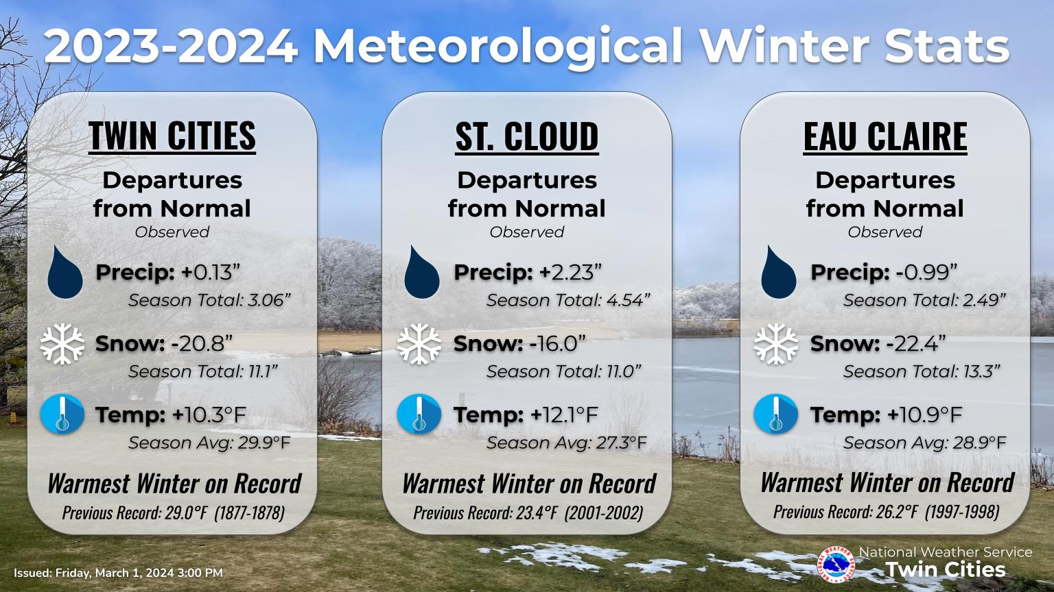
We hit 64 at one of the 5min obs, before some high clouds moved in. We’ll see this evening if it’s the official high. Warmest winter on record in the bag.
-
Winter '23-'24 Piss and Moan/Banter Thread
OrdIowPitMsp replied to IWXwx's topic in Lakes/Ohio Valley
The record warmth this winter is one thing, it happens every 150 years or so around these parts. The zzzzzz pattern we’ve been in since Christmas with nothing to track is wearing on me though. -
34 and a snow shower moving through. Deck and remaining snow is dusted.
-
Winter '23-'24 Piss and Moan/Banter Thread
OrdIowPitMsp replied to IWXwx's topic in Lakes/Ohio Valley
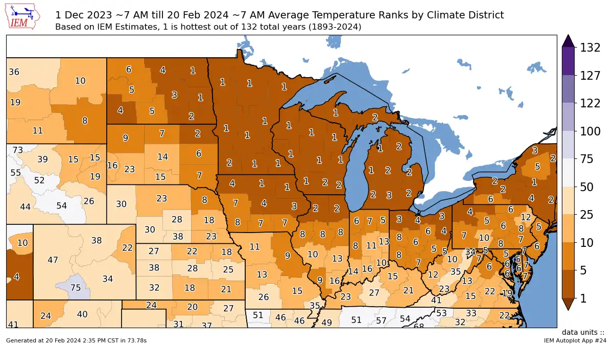
If one image could tell the whole story…
-
Winter 2023/24 Medium/Long Range Discussion
OrdIowPitMsp replied to Chicago Storm's topic in Lakes/Ohio Valley
Very dry on the long range in MN. This is going to be an early and odd spring. -
Snow depth down to 2” at 6am. It will likely be a T at tomorrows observation with the forecast high of 44 today.
-
Recorded a high of 14 yesterday, below guidance for a change. Overnight we’ve fallen to 8 so far, which is one of the colder low temps in this “winter”
-
Winter '23-'24 Piss and Moan/Banter Thread
OrdIowPitMsp replied to IWXwx's topic in Lakes/Ohio Valley
Is this cumulative days of 1” depth in a season or consecutive streak? If it’s the former I’m surprised it’s not over 100. -
Low of 10 overnight. One more day of deep winter until we thaw again. Very well could be our coldest morning for the rest of winter looking at the extended.