OrdIowPitMsp
-
Posts
2,299 -
Joined
-
Last visited
Content Type
Profiles
Blogs
Forums
American Weather
Media Demo
Store
Gallery
Everything posted by OrdIowPitMsp
-
56 with drizzle/fog/mist. Having a lovely lunch on Madeline Island before heading over to Big Bay State Park for a hike.
-

Late June 2024 MN/WI/IA Flooding Event
OrdIowPitMsp replied to Geoboy645's topic in Lakes/Ohio Valley
0.63” overnight in Minneapolis. -
Late June 2024 MN/WI/IA Flooding Event
OrdIowPitMsp replied to Geoboy645's topic in Lakes/Ohio Valley
So far the twin cities have avoided almost all the rain as the training storms setup just south. Sun is even coming out here in Bayfield. -
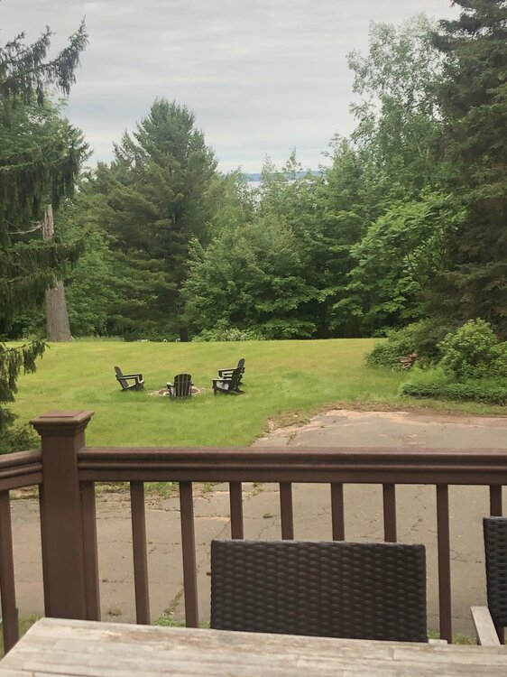
As forecast it’s a gloomy morning in Bayfield WI. Doesn’t take much away from the beauty of this area though. Lake Superior and Madeline Island are peaking through the trees from the back windows of our rental cabin. High of 58 today and tomorrow.
-
64/52 under thickening overcast. Perfect autumn day.
-
Late June 2024 MN/WI/IA Flooding Event
OrdIowPitMsp replied to Geoboy645's topic in Lakes/Ohio Valley
Relentless.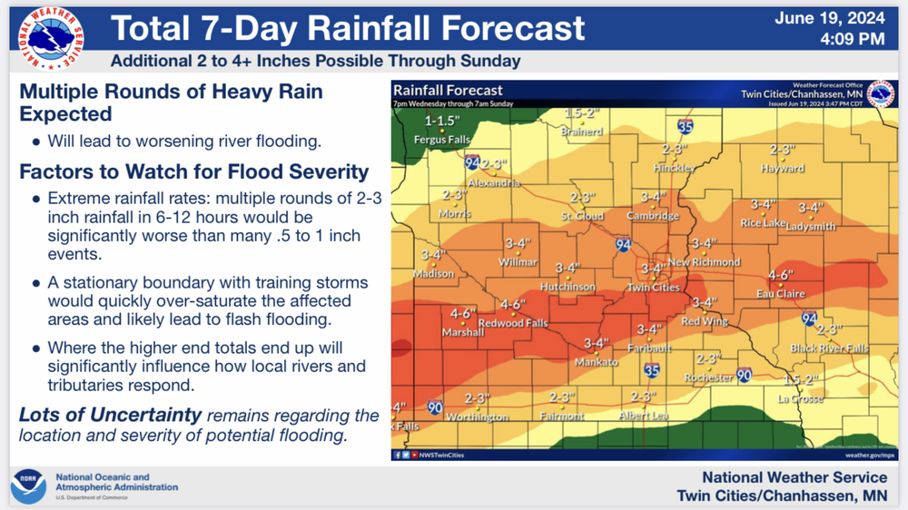
-
Late June 2024 MN/WI/IA Flooding Event
OrdIowPitMsp replied to Geoboy645's topic in Lakes/Ohio Valley
@Brian Dany idea where this TH report was taken.
-
Partly cloudy with temps in the upper 60s currently. We only picked up 0.35” of rain last night, the storms really blew up overhead and dumped a lot more rain just to the east. After dews in the 70s yesterday having them drop into the low 50s is great.
-
Late June 2024 MN/WI/IA Flooding Event
OrdIowPitMsp replied to Geoboy645's topic in Lakes/Ohio Valley
I rented a cabin in Bayfield WI, Thursday-Sunday. Looks like a chilly and wet weekend unfortunately. -
Late June 2024 MN/WI/IA Flooding Event
OrdIowPitMsp replied to Geoboy645's topic in Lakes/Ohio Valley
Yes, everything just west of the Sawtooth Mtns drains into Superior. Lots of waterfalls and fast moving water up there as the terrain drops 1000’ in only a few miles. I wouldn’t want to be backpacking the Superior Hiking Trail, those bridges wash out all time. -
Late June 2024 MN/WI/IA Flooding Event
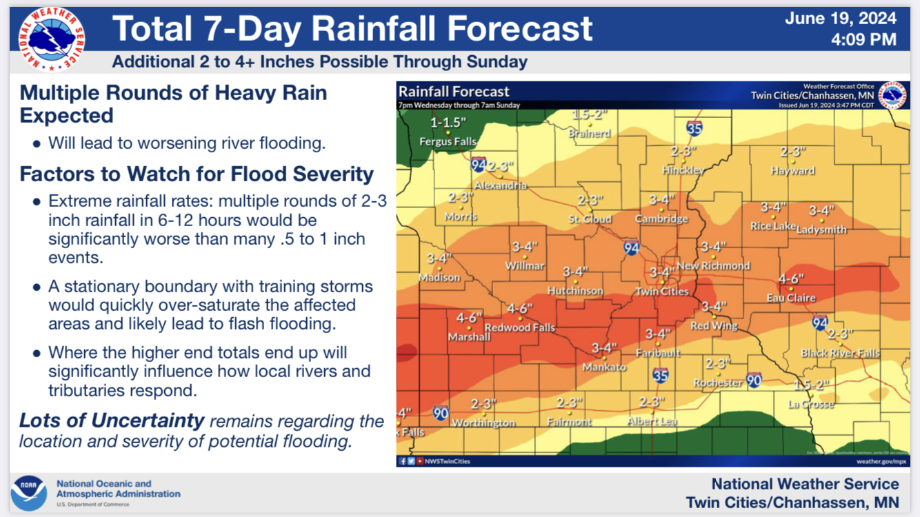
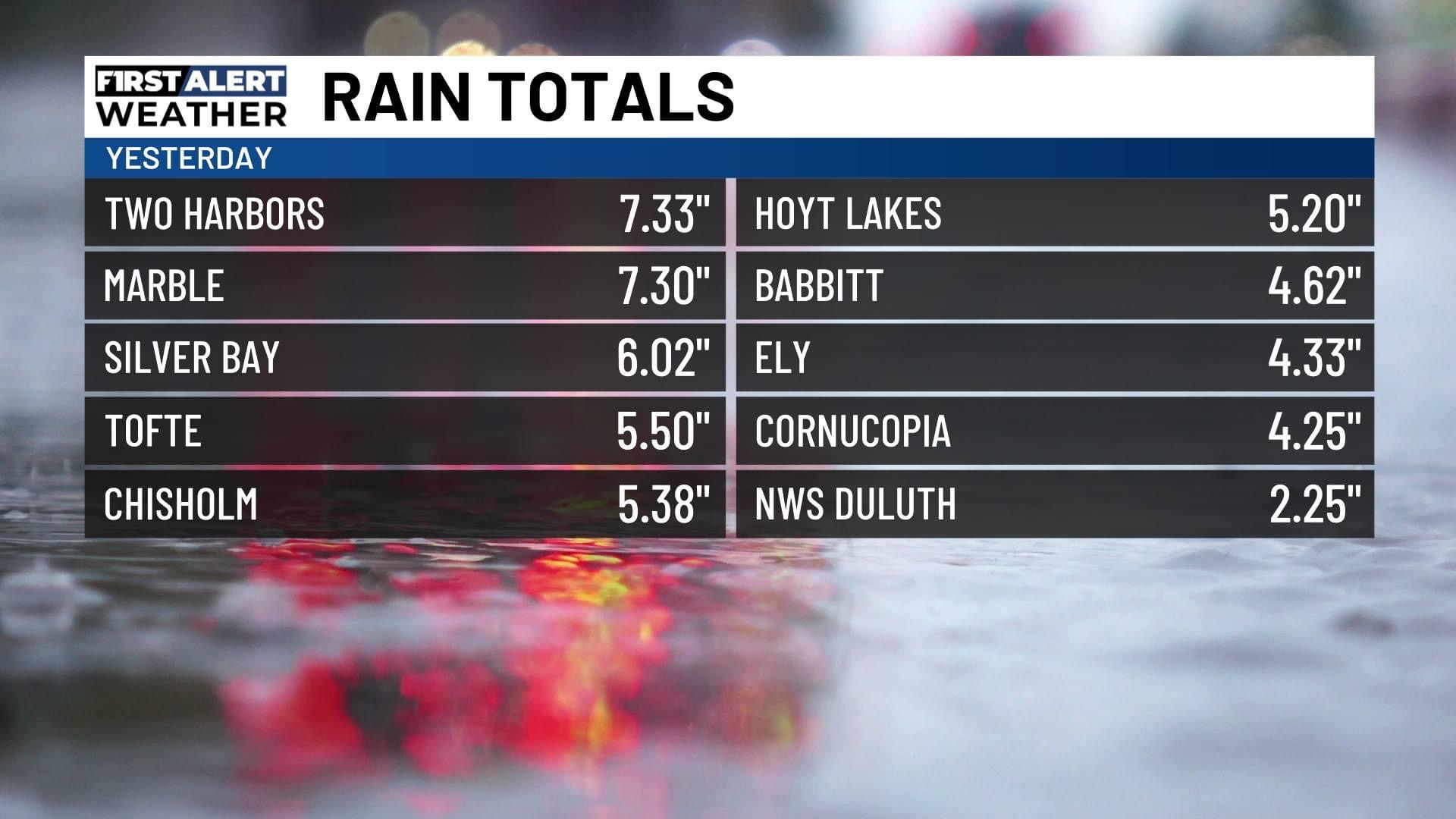
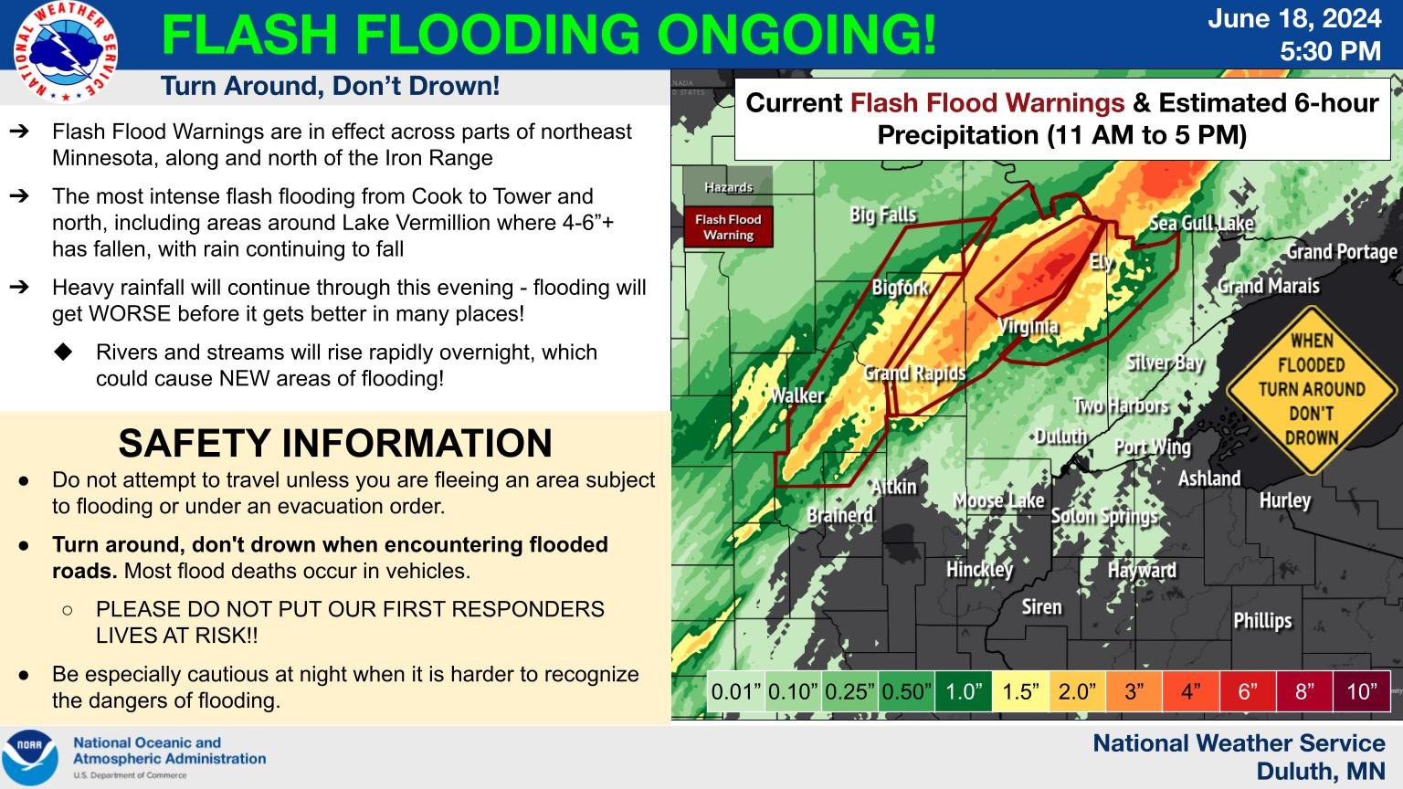
OrdIowPitMsp replied to Geoboy645's topic in Lakes/Ohio Valley
Very hefty rainfall totals in northern Minnesota with a flash flood ongoing. Looks like 4-6” has fallen with more still to come NW of a line from Grand Rapids through Ely.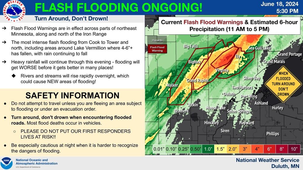
-
June 16th-21st (and beyond?) Heatwave
OrdIowPitMsp replied to Geoboy645's topic in Lakes/Ohio Valley
Rollercoaster weather continues in Minneapolis. It’s 79/70 at 8:30am, temps and dews steadily rose throughout the overnight hours. -
June 16th-21st (and beyond?) Heatwave
OrdIowPitMsp replied to Geoboy645's topic in Lakes/Ohio Valley
63 in Minneapolis lol -
It was 72 at 5:00am. The rain moved in and now it’s 57 at 10:00am.
-
Late June 2024 MN/WI/IA Flooding Event
OrdIowPitMsp replied to Geoboy645's topic in Lakes/Ohio Valley
Ready 2 flood. 0.35” today so far. All day washout incoming -
June 16th-21st (and beyond?) Heatwave
OrdIowPitMsp replied to Geoboy645's topic in Lakes/Ohio Valley
89’d -
June 16th-21st (and beyond?) Heatwave
OrdIowPitMsp replied to Geoboy645's topic in Lakes/Ohio Valley
Just tagged 90 at MSP. 90/72 at 5pm -
June 16th-21st (and beyond?) Heatwave
OrdIowPitMsp replied to Geoboy645's topic in Lakes/Ohio Valley
We’ve jumped from 82 to 88 in the past 90 minutes. -
Late June 2024 MN/WI/IA Flooding Event
OrdIowPitMsp replied to Geoboy645's topic in Lakes/Ohio Valley
1.57” total precipitation last 24hrs. -
Late June 2024 MN/WI/IA Flooding Event
OrdIowPitMsp replied to Geoboy645's topic in Lakes/Ohio Valley
0.94” of rain yesterday. We had a midnight high of 70 but it was stuck in the mid 60s all day. Different story today. -
68 here with scattered showers that should become more numerous as the day progresses. Temps will probably hold steady. Good day to run errands, watch the kiddos act rowdy with cabin fever and watch the rain.
-
Summer 2024 Medium/Long Range Discussion
OrdIowPitMsp replied to Chicago Storm's topic in Lakes/Ohio Valley
Luckily the lakes are still a little low after 3 summers of flash drought and a mostly snowless winter, so they can take some runoff. In 2019 Minnehaha Creek was flowing over the Grays Bay Dam spillway at Lake Minnetonka for a few weeks, it caused minor flooding along the trails at the lake down the block from my house. (Nokomis) The Mississippi River downstream from St. Anthony’s Falls is in a gorge which acts like a giant storm sewer for the cities, but if rainfall rates are high enough there will definitely be urban flood potential. As you mentioned the suburbs have exploded with growth over the past 30 years so newer built areas will definitely be put to the test. I did the geotech work on a massive flood control project that MNDOT finished up last year, time to put this system to the test. https://www.kare11.com/article/news/local/mndot-builds-massive-storm-drainage-tanks-along-35w/89-461d7b05-01d7-4b6d-9181-c0a7bf753fe8 -
Summer 2024 Medium/Long Range Discussion
OrdIowPitMsp replied to Chicago Storm's topic in Lakes/Ohio Valley
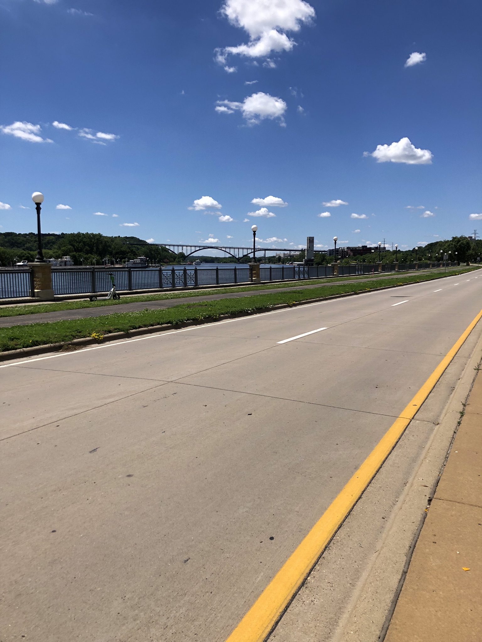
I’m working along the Mississippi in downtown St. Paul this afternoon. River is bank full and there is minor flooding along the typical low lying areas. Any more then 2-3” of rain and we’ll have big problems.
-
June 16th-21st (and beyond?) Heatwave
OrdIowPitMsp replied to Geoboy645's topic in Lakes/Ohio Valley
Just goes to show the variability in our region, Minneapolis is just far enough west to have a chinook effect and doesn’t have a Great Lake to moderate temperatures. I love living somewhere it can be -25 in winter and +100 in summer. Meanwhile WSW across western Montana, 4-6” of snow above 6,000 with 14-20” across the higher terrain. Wild stuff for the middle of June. -
June 16th-21st (and beyond?) Heatwave
OrdIowPitMsp replied to Geoboy645's topic in Lakes/Ohio Valley
Seems like the pattern I’ve been stuck in the past 3 summers has shifted east. Flash drought is no fun, I’ve already mowed my lawn as much as I did all of last summer.