OrdIowPitMsp
-
Posts
2,299 -
Joined
-
Last visited
Content Type
Profiles
Blogs
Forums
American Weather
Media Demo
Store
Gallery
Everything posted by OrdIowPitMsp
-
Wet morning here with more on/off showers. Temps sitting at 68, feels like a whole different season today.
- 231 replies
-
- 1
-

-
- absolute trainwreck?
- abandon all hope?
- (and 1 more)
-
- 231 replies
-
- 1
-
-
- absolute trainwreck?
- abandon all hope?
- (and 1 more)
-
1.62” 24 hour rain total. 0.37” after midnight to start August.
-
1.12” in about 40min.
-
Heavy rainer with the occasional hailstone. Solid stuff.
-
Over 3” of rain fell overnight in Des Moines.
-
90 for the high today. Rain free.
-
Most of the storms missed us, only ended up with 0.36” overnight. Another hot week on tap with temps running 85-90 daily. Hopefully we can get in on some MCS action.
-
Bagged our 3rd 90 of the year with a brief high of 90 today. Storms are doing a good job of dodging mby so far this evening.
-
High of 91 yesterday. Warmest temp of the year. Will make another run at 90 today, dews are running 65-67 today versus 68-70 yesterday.
-
88/70 currently. Swamp weather outside. Should bag our 2nd 90 of the year soon.
-
High of 81 yesterday, the first prolonged heatwave of the summer begins today for the Twin Cities. We look to have a week+ stretch of 85-90 degree weather and ~70 dews. July is running -1.6 below average so far. That deficient will be eaten away these last several days of the month.
-
High of 75 today. Another top shelf day. Dog days of summer are lurking though.
-
Storms fired along the cold front and deposited a quick 0.54” here.
-
Slow moving storms dumping about an inch of rain imby this morning. The airport picked up 0.74”
-
Garden variety storms popping up over the metro this morning. Some locally heavy rainfall but that’s about it.
-
Low 80s and daily storm chances. Pretty darn good. High altitude smoke is a bummer but it’s an inevitable part of the modern summer.
-

Summer 2024 Medium/Long Range Discussion
OrdIowPitMsp replied to Chicago Storm's topic in Lakes/Ohio Valley
Upper atmospheric smoke has entered central and southern Minnesota. AQ is still fine but the milky skies are back. Hope it stays elevated. -
Top shelf weather this week. Feels like a mid September day this morning. High of 74 today, dew point sitting pretty at 52.
-
2024 Short/Medium Range Severe Weather Discussion
OrdIowPitMsp replied to Chicago Storm's topic in Lakes/Ohio Valley
This is some wild stuff. Hope everyone is safe. -
-
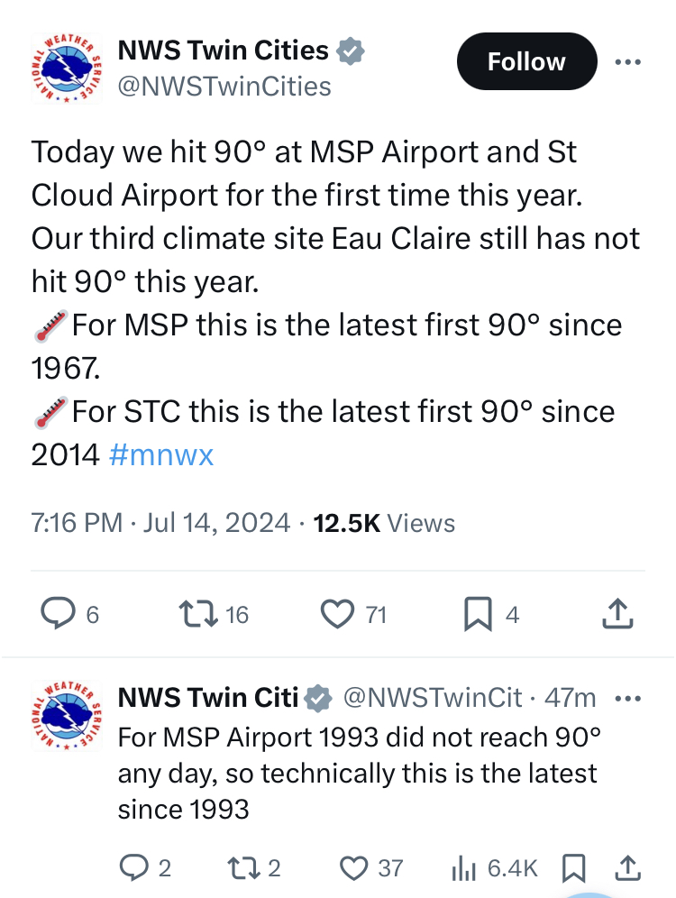
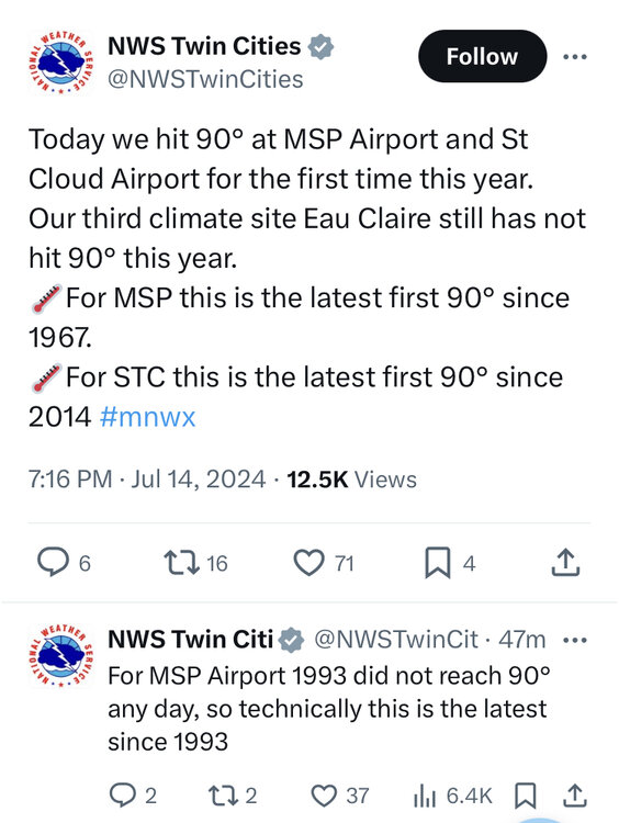
Preliminary data looks like we achieved 90 today in Minneapolis.
-
Short but sweet, was worth staying up late on a Saturday night to watch multiple 60mph gusts move through the neighborhood.
-
Forecast high was 91 today. Actual high 81 with 0.34” of rain. Next up is an overnight MCS
-
Another cloudburst just put the airport on a brief ground stop. Quarter mile visibility and frequent CtG lightning. The razor thin line of showers/storms along I-94 backs up west of St. Cloud. 74 at 2pm. Going to be tough to break 90 today. @Chicago Stormgotta hand it to you for sensing temps would likely underperform today. You should do some consulting work for our WFO.