CADEffect
-
Posts
109 -
Joined
-
Last visited
Content Type
Profiles
Blogs
Forums
American Weather
Media Demo
Store
Gallery
Everything posted by CADEffect
-
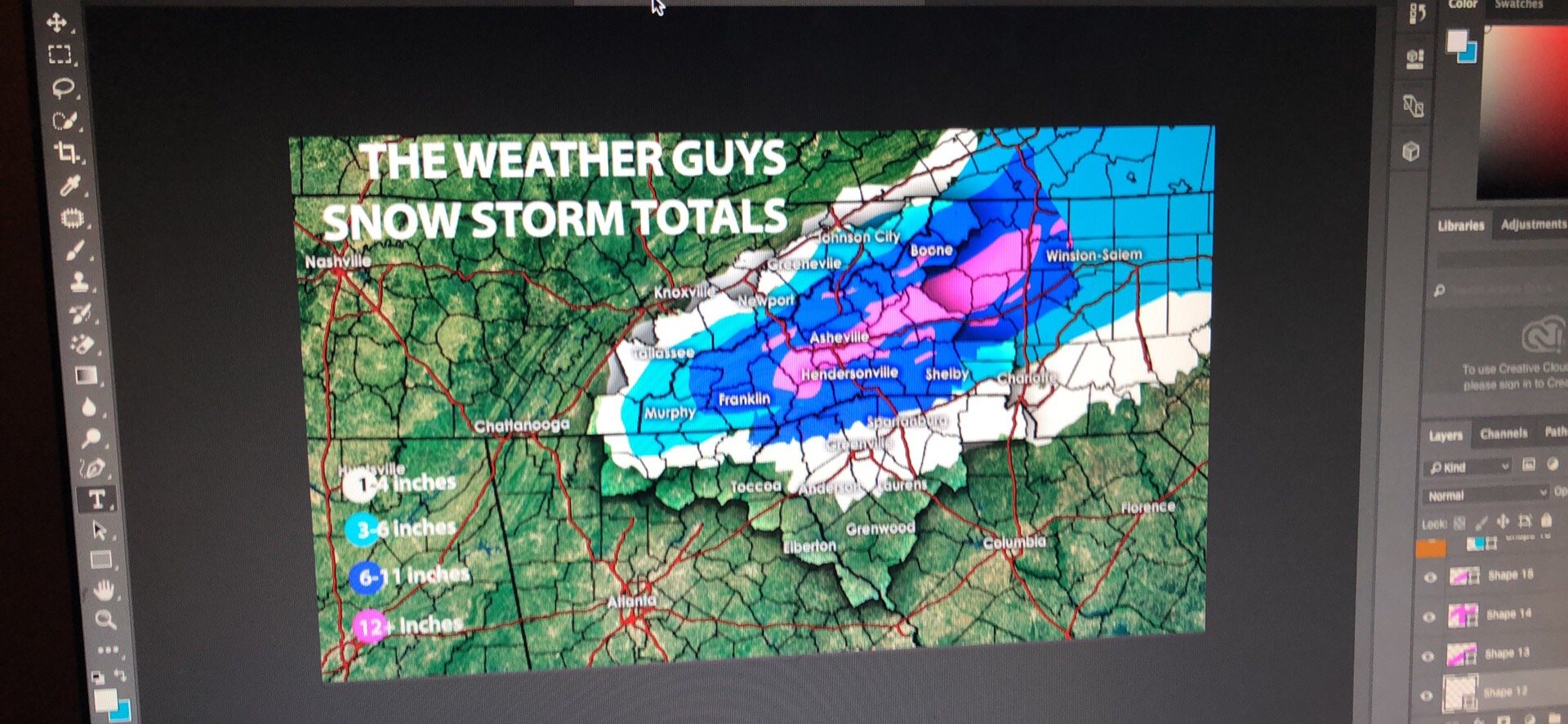
This was my forecast for last night. For SNOW

-
This was my forecast for last night.

-
I don’t know if there is a site or if this is available however, is there a place I can get live soundings anywhere?
-
What are you looking at? The soundings isn’t really under 32 the entire storm across the Upstate.
-
I think storm Vista is the only service right now with 6hr euro runs
-
Elevation?
-
Something to consider the convection along the Gulf Coast needs to stay in check. Anyone else seen if it will be a problem for QPF
-
I intend to agree with you. Checking upstream now
-
Heck of a warm nose though on soundings
-
How does GSP and Upstate look South Carolina thanks for the pbp
-
Yes I seen that. Hopefully FV3 will be similar
-
It’s possible the surface temps are not cooling as fast on 3knam over the upstate SC area. Compared to 32k nam. As mention earlier by another poster. The NAMs need to get on the same page. FAST.
-
GSP just as bad if not worse
-
Yes, the upstate in a very icy spot today
-
Dang right that’s a lot of freezing rain
-
Should put more stock into FV3 then old version of GFS
-
I want to continue to see colder temps moving south on the FV3 I hope the trend south on the Operational models hasn’t stopped. Sorry VA, but the upstate S.C. doesn’t score as well as you do.
-
I want to learn soundings fast. Best way to do that???
-
Would love to see 18z and 00z continue the 850’s moving south across the upstate SC. Maybe NAM moving slowly toward the GFES and EURO.
-
Another quick question at this point in the game do you start looking at the precipitation field more in short term models are continue to watch the op models?
-
No sir, I have not. Would it be different then what the overall model predicts?
-
Guys, perhaps you all could help me out. I’m trying to understand I’m in the upstate S.C. area. Pivotal has a crippling freezing rain event on its NAM ICE accumulation algorithm. When I checked the NAM 850 across most if not all the area it’s above freezing. I even checked the 2m temps and it was above freezing. It still had a ice storm. I didn’t bother checking the upper levels after seeing both levels above freezing. Please help me understand what am I missing?
-
I’m really getting concerned with Iceing issues across Upstate SC. Just curious to know if NAM is a trend or not.
-
Winter Weather Update Hi resolution models are starting to paint a picture. Some of you won’t like it. I’m beginning to get concerned for two areas of interest for two very different types of precipitation. First, the NAM model continues to produce some higher snow totals for places like Asheville N.C. To points East-Northeast Hickory N.C. Including even Boon N.C. The up-sloping snow will get lift from the higher terrain and cause heavy snow in some spots. Elevations 3k, to 4K ft. Will have possible 40mph winds creating blizzard like conditions especially on the east side of the mountains. I’m looking at total estimates later tonight. heavy snow is also possible for places like central north Georgia. The precipitation may be delayed thanks to the cold air damming of dry air. Second, I’m growing concern for places south of Interstate 85 across the upstate S.C. and parts of northeast Georgia. A possible ICE storm as far across the state to Sumter and Florence S.C. is even in play. However, rain will often mix with the ice to limit the ice accumulation (as it looks now). That may change if the NAM trends cooler.
-
Chris justice giving totals three days out