

Hotair
-
Posts
437 -
Joined
-
Last visited
Content Type
Profiles
Blogs
Forums
American Weather
Media Demo
Store
Gallery
Posts posted by Hotair
-
-
Eyewall is closed. If we luck out it will be in ERC mode when It makes an approach on the coast.
-
“National Hurricane Center director calls Ian forecast a "near worst-case scenario" for the Tampa area.” “This would be the storm of a lifetime for many Tampa Bay residents,” he added.
for a long time I’ve admired the power of these beautiful storms. While I know they are destructive and deadly I still hold Nothing but awe. Looking at the visual on satellite today I have to say that Ian has more than earned my respect and if it goes on to destroy my home I will try not to be bitter or angry. A formidable cane is a thing of beauty for me. I’m sure I’m not the only one on this board who feels this way.
-
 4
4
-
 1
1
-
-
It’s bad enough that latest model runs took a further jog East. NHC incoming 5 pm will likely put TB dead center on their cone
-
What’s the over under that Ian gets retired after this week?
-
6 hours ago, Jersey Devil said:
Family in Largo, has option to go to Gainesville. Take it?
Largo is in Pinellas right. .? Evac for zone A tonight and B and C tomorrow. If you are in those zones you should consider bugging out
-
1
-
-
Satellite has Ian as a 90 MPH hurricane now with a pressure of 976 mb almost Cat 2 . We should have two additional Hunter planes in the storm soon
-
9 minutes ago, 1234snow said:
Stupid question here…. Does the shape of Cuba’s coastline help to tighten up Ian’s core in this situation? The outer bands of convection seems to line up very well with the southern coastline currently as they rotate counter clockwise parallel to the shore.
It does but would be best (for the US) if it stayed over the island longer. In the current trajectory and speed it will be clear of land effects in short order.
-
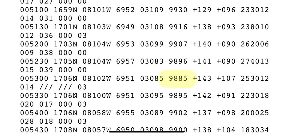
New recon data for Ian shows flight level winds have increased to 79kt while ex. pressure has dropped to 977.0mb which os consistent with a deepening storm. Window for preparations in Havana and western Cuba is coming to a close soon.
im in Lakeland now where I expect to ride out whatever comes.
-
18 minutes ago, Prospero said:
Not looking good for Tampa Bay. Our home is five blocks from Boca Ciega Bay at about 15ft elevation. We are not considered in a flood zone, but a 15 foot storm surge is not impossible.
Yep. My worst nightmare is unfolding. Had neighbor helping us with some sandbags. Will be leaving after rush hour to son’s house in Lakeland Everything wife and I could move is off the floor just in case we get lucky last minute and flooding is not what is expected. Frankly can’t see how we don’t get 2 to 4+ feet or more into the house as we have 10 ft elevation from SL -older house. Newer houses are all elevated in my area and have living areas about 10 or 12 feet above ground
once I saw Jim Cantore land in Clearwater yesterday I knew the jig was up.
-
2
-
 2
2
-
-
Unflagged 988.5 found. So we more than likely wake up to a CAT 1 in the morning
-
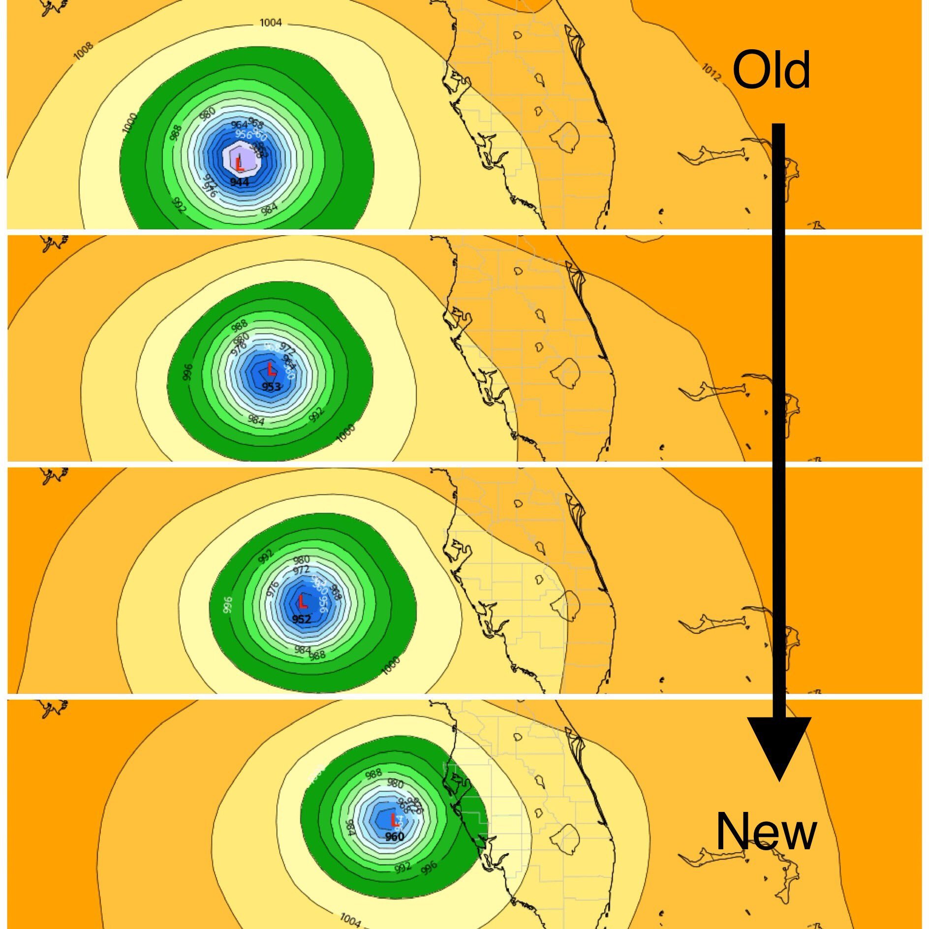
Prior 4 GFs runs all at 8pm Wednesday. The correction to the East is dramatic

-
1
-
1
-
-
@LopWx
A strong cold front from Canada, battling out the warm moist air of Ian. The cold front slows down Ian a lot, which will allow for more storm surge, and tons of rain to be dumped on parts of Central and Western Florida
-
1
-
-
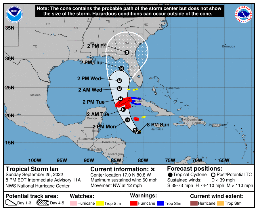
NHC not yet ready to shift cone further East.
-
000
WTNT34 KNHC 252357
TCPAT4

BULLETIN
Tropical Storm Ian Intermediate Advisory Number 11A
NWS National Hurricane Center Miami FL       AL092022
800 PM EDT Sun Sep 25 2022

...IAN STRENGTHENING...
...EXPECTED TO PRODUCE SIGNIFICANT WIND AND STORM SURGE IMPACTS
IN WESTERN CUBA...


SUMMARY OF 800 PM EDT...0000 UTC...INFORMATION
----------------------------------------------
LOCATION...17.0N 80.8W
ABOUT 160 MI...260 KM S OF GRAND CAYMAN
ABOUT 430 MI...695 KM SE OF THE WESTERN TIP OF CUBA
MAXIMUM SUSTAINED WINDS...60 MPH...95 KM/H
PRESENT MOVEMENT...NW OR 310 DEGREES AT 12 MPH...19 KM/H
MINIMUM CENTRAL PRESSURE...991 MB...29.26 INCHES


WATCHES AND WARNINGS
--------------------
CHANGES WITH THIS ADVISORY:

None.

SUMMARY OF WATCHES AND WARNINGS IN EFFECT:

A Hurricane Warning is in effect for...
* Grand Cayman
* Cuban provinces of Isla de Juventud, Pinar del Rio, and Artemisa

A Tropical Storm Warning is in effect for...
* Cuban provinces of La Habana, Mayabeque, and Matanzas

A Tropical Storm Watch is in effect for...
* Little Cayman and Cayman Brac
* Lower Florida Keys from Seven Mile Bridge southward to Key West,
including the Dry Tortugas

A Hurricane Warning means that hurricane conditions are expected
somewhere within the warning area.  A warning is typically issued
36 hours before the anticipated first occurrence of tropical-storm-
force winds, conditions that make outside preparations difficult or
dangerous.  Preparations to protect life and property should be
rushed to completion.

A Tropical Storm Warning means that tropical storm conditions are
expected somewhere within the warning area within 36 hours.

A Tropical Storm Watch means that tropical storm conditions are
possible within the watch area, generally within 48 hours.

Interests in central Cuba, the remainder of the Florida Keys, and
the Florida peninsula should monitor the progress of Ian.

For storm information specific to your area, please monitor
products issued by your national meteorological service.


DISCUSSION AND OUTLOOK
----------------------
At 800 PM EDT (0000 UTC), the center of Tropical Storm Ian was
located near latitude 17.0 North, longitude 80.8 West.  Ian is
moving toward the northwest near 12 mph (19 km/h).  A turn toward
the north-northwest is expected on Monday followed by a northward
motion on Tuesday with a slightly slower forward speed.  On the
forecast track, the center of Ian is expected to pass near or west
of the Cayman Islands on Monday, and near or over western Cuba
Monday night and early Tuesday.  Ian will then emerge over the
southeastern Gulf of Mexico on Tuesday.

Maximum sustained winds have increased to near 60 mph (95 km/h)
with higher gusts.  Additional strengthening is forecast tonight,
followed by more rapid strengthening on Monday and Tuesday.  Ian is
forecast to become a hurricane on Monday and a major hurricane on
Tuesday.

Tropical-storm-force winds extend outward up to 35 miles (55 km)
from the center.

The minimum central pressure estimated from NOAA Hurricane Hunter
aircraft observations is 991 mb (29.26 inches).


HAZARDS AFFECTING LAND
----------------------
Key messages for Ian can be found in the Tropical Cyclone Discussion
under AWIPS header MIATCDAT4 and WMO header WTNT44 KNHC and on the
web at hurricanes.gov/text/MIATCDAT4.shtml.

WIND:  Hurricane conditions are expected to reach Grand Cayman on
Monday, with tropical storm conditions beginning late tonight.
Hurricane conditions are expected within the warning area in Cuba by
early Tuesday, with tropical storm conditions expected by late
Monday.

Tropical storm conditions are expected within the tropical storm
warning area in Cuba Monday night and Tuesday.  Tropical storm
conditions are possible on Little Cayman and Cayman Brac on Monday.
Tropical storm conditions are possible in the lower Florida Keys by
Tuesday.

RAINFALL:  Ian is expected to produce the following rainfall:

Jamaica and the Cayman Islands: 3 to 6 inches, with local maxima up
to 8 inches.

Western Cuba: 6 to 10 inches, with local maxima up to 16 inches.

Florida Keys into southern and central Florida Peninsula: 2 to 4
inches, with local maxima up to 6 inches beginning Monday through
Wednesday morning.

Heavy rainfall may affect North Florida, the Florida Panhandle and
the Southeast Thursday, Friday and Saturday.

These rains may produce flash flooding and mudslides in areas of
higher terrain, particularly over Jamaica and Cuba. Flash and urban
flooding are possible across the Florida Keys and the Florida
peninsula through mid week. Additional flooding and rises on
area streams and rivers across northern Florida and parts of the
southeast U.S. later this week cannot be ruled out, especially in
central Florida given already saturated conditions.

STORM SURGE:  The combination of storm surge and the tide will
cause normally dry areas near the coast to be flooded by rising
waters moving inland from the shoreline.  The water could reach the
following heights above ground somewhere in the indicated areas if
the peak surge occurs at the time of high tide...

East Cape Sable, FL to Card Sound Bridge...1-3 ft
Florida Keys, FL including Dry Tortugas...1-3 ft
Florida Bay...1-3 ft

The deepest water will occur along the immediate coast near and to
the right of the center, where the surge will be accompanied by
large waves.  Surge-related flooding depends on the relative timing
of the surge and the tidal cycle, and can vary greatly over short
distances.  For information specific to your area, please see
products issued by your local National Weather Service forecast
office.

Storm surge could raise water levels by as much as 9 to 14 feet
above normal tide levels along the coast of western Cuba in areas
of onshore winds in the hurricane warning area Monday night
and early Tuesday.

Storm surge could raise water levels by as much as 2 to 4 feet above
normal tide levels along the immediate coast in areas of onshore
winds in the Cayman Islands Sunday night into Monday.

SURF:  Swells generated by Ian are affecting Jamaica and the Cayman
Islands. Swells will spread northwestward to the southwestern coast
of Cuba and the coasts of Honduras, Belize, and the Yucatan
Peninsula of Mexico on Monday and Monday night. These swells are
likely to cause life-threatening surf and rip current conditions.
Please consult products from your local weather office.


NEXT ADVISORY
-------------
Next complete advisory at 1100 PM EDT.

$$
Forecaster Pasch
-
I don’t think the euro has Ian as intense at this hour as it’s been found to be on recon dropsonde.
I wonder how that will affect the euro model on the next run once that data gets absorbed?
-
Unfortunately, Ian strengthening and moving further North and East of cone , means Havana Cuba is in for a rough ride Monday night to Tuesday.
I doubt their electricity infrastructure is any better than Puerto Rico’s -
If Ian follows the euro model trajectory it will definitely have its name retired. Yet another “I” for posterity.
-
1
-
-
Latest recon at 989 should prompt NHC to issue a special advisory shortly upgrading Ian to a Cat 1 cane
-
4 minutes ago, AnthonyEC said:
I agree, if you aren’t 10-15 feet above sea level, I would find a place that is.
I will be traveling inland to my son’s. Getting on road tomorrow
-
7 minutes ago, MattPetrulli said:
Surge will be bad, but lets not under estimate the potential for a Cat 2-3 eyewall to be going through Tampa. They have great building codes but that would cause significant damage regardless.
Great. And I wasn’t going to mention this but my neighbor had their policy non renewed by their ins co. I found out yesterday he decided to sit on it until next year because he was convinced the Hurricane threat was done for the year. ( his house is paid for). Now he can only buy insurance with a 15 day grace period meaning he is going commando into this storm.
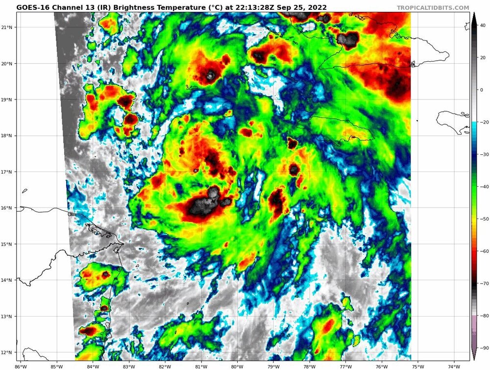
convective burst is much better organized now than earlier. I think we are going to start buzz sawing soon
-
2 minutes ago, Prospero said:
Hurricane Agnes was biggest surge we've had in about 100 years. Wind was a non-issue, rain was nothing memorable. But the 10ft Storm Surge across Tampa Bay was indeed something to remember.
That is a 10ft surge. We hear about 30 ft sometimes when we are in the cone of a big one.
Sections of road in my neighborhood in South Tampa become impassable by cars after a heavy rain fall lasting 20 minutes. If you throw the Bay waters at us during hurricanes we will have many homes flooded. I would love to see how the tide tables match up with the storm arrival. High tide could easily add 4+ feet to the surge
-
22 minutes ago, SnowenOutThere said:
If the euro is correct they got 3 days to prepare.
2 and a half to be safe. Probably don’t want to evacuate under major lightning storms. At least hillsborough schools have been cancelled now in preparation of storm shelters.
-
2
-
-
18z Icon almost bring Naples into LF
-
6 minutes ago, SnowGoose69 said:
A tad surprised the cone is not a bit more E on the right side there
Same here but then again, they have most of the West Coast population centers covered with the cone as is. Perhaps they are waiting for a few more GFS runs to confirm the shift East


Hurricane Ian
in Tropical Headquarters
Posted
From NHC discussion 5 pm