Hotair
-
Posts
539 -
Joined
-
Last visited
Content Type
Profiles
Blogs
Forums
American Weather
Media Demo
Store
Gallery
Everything posted by Hotair
-

-
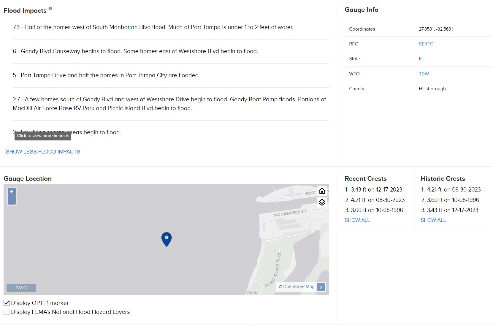
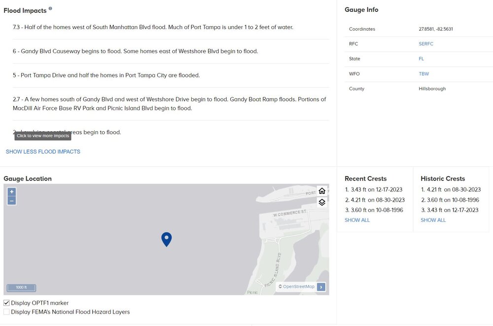
Oh I missed that Thanks! here are potential flood impacts to Tampa area from storm surge.
-
The satellite presentation suggests to me this is a large system. I know eyeballing is not encouraged in this forum but has anyone here opined as to the relative size of Helene to other gulf storms in recent past?
-
Bingo. Plus it puts the coc East of where the models have this storm located at this juncture. But I promise to keep silent until the recon data arrives.
-
I’m probably mistaken but to me it appears as if it is even nudging N/NE
-
Ah makes sense. I didn’t know that was the cadence. Thanks!
-
I’m told this is the fourth Helene storm of this century. priors are 2006, 2012, 2018, and now in 2024. So appears she likes to visit every six years. Remind me in 2030 - lol
-
They are among the best on the world. I have to say though there are many amateur Mets here who frequently catch things that are either missing from the published NHC statements or help to better explain the forecast rationale issued by the NHC. Also NHC is great but not always perfect, so it’s always healthy to have a diverse set of eyes and opinions on the data as it evolves.
-
Very appropriate considering the unknowns and the certainty that this event will happen mid week without the luxury for most to prepare over a weekend.
-
Helene is born. Will there be a new thread ? Or rename this one ? 062 WTNT34 KNHC 241458 TCPAT4 BULLETIN Tropical Storm Helene Advisory Number 5 NWS National Hurricane Center Miami FL AL092024 1100 AM EDT Tue Sep 24 2024 ...TROPICAL STORM HELENE FORMS OVER THE NORTHWESTERN CARIBBEAN SEA... ...HURRICANE AND STORM SURGE WATCHES REMAIN IN EFFECT FOR PORTIONS OF THE FLORIDA GULF COAST... SUMMARY OF 1100 AM EDT...1500 UTC...INFORMATION ----------------------------------------------- LOCATION...19.5N 84.3W ABOUT 180 MI...295 KM ESE OF COZUMEL MEXICO ABOUT 170 MI...275 KM SSE OF THE WESTERN TIP OF CUBA MAXIMUM SUSTAINED WINDS...45 MPH...75 KM/H PRESENT MOVEMENT...NW OR 310 DEGREES AT 12 MPH...19 KM/H MINIMUM CENTRAL PRESSURE...1000 MB...29.53 INCHES WATCHES AND WARNINGS -------------------- CHANGES WITH THIS ADVISORY: A Tropical Storm Warning has been issued for the Lower Florida Keys west of the Seven Mile Bridge and for the Dry Tortugas. A Tropical Storm Watch has been issued for the Middle Florida Keys from the Seven Mile Bridge to the Channel 5 Bridge. SUMMARY OF WATCHES AND WARNINGS IN EFFECT: A Storm Surge Watch is in effect for... * Indian Pass southward to Flamingo * Tampa Bay * Charlotte Harbor A Hurricane Watch is in effect for... * Cabo Catoche to Tulum, Mexico * Cuban province of Pinar del Rio * Englewood to Indian Pass * Tampa Bay A Tropical Storm Warning is in effect for... * Dry Tortugas * Lower Florida Keys west of the Seven Mile Bridge * Grand Cayman * Rio Lagartos to Tulum, Mexico * Cuban provinces of Artemisa, Pinar del Rio, and the Isle of Youth A Tropical Storm Watch is in effect for... * Middle Florida Keys from the Seven Mile Bridge to the Channel 5 Bridge * Flamingo to south of Englewood * West of Indian Pass to Walton Bay County line A Storm Surge Watch means there is a possibility of life- threatening inundation, from rising water moving inland from the coastline, in the indicated locations during the next 48 hours. For a depiction of areas at risk, please see the National Weather Service Storm Surge Watch/Warning Graphic, available at hurricanes.gov. A Tropical Storm Warning means that tropical storm conditions are expected somewhere within the warning area within the next 36 hours. A Hurricane Watch means that hurricane conditions are possible within the watch area. A watch is typically issued 48 hours before the anticipated first occurrence of tropical-storm-force winds, conditions that make outside preparations difficult or dangerous. A Tropical Storm Watch means that tropical storm conditions are possible within the watch area, generally within 48 hours. Wind and storm surge warnings will likely be required for the U.S. later today. For storm information specific to your area in the United States, including possible inland watches and warnings, please monitor products issued by your local National Weather Service forecast office. For storm information specific to your area outside of the United States, please monitor products issued by your national meteorological service. DISCUSSION AND OUTLOOK ---------------------- At 1100 AM EDT (1500 UTC), the center of Tropical Storm Helene was located near latitude 19.5 North, longitude 84.3 West. Helene is moving toward the northwest near 12 mph (19 km/h), and this general motion is expected to continue through early Wednesday. A northward to north-northeastward motion at a faster forward speed is expected on Wednesday and Thursday. On the forecast track, the center of Helene will move across the far northwestern Caribbean Sea through tonight, and then move across the eastern Gulf of Mexico Wednesday and Thursday, potentially reaching the Gulf coast of Florida late Thursday. Data from an Air Force Reserve Hurricane Hunter aircraft indicate that the system has acquired a well-defined center of circulation, and maximum sustained winds have increased to near 45 mph (75 km/h) with higher gusts. Additional strengthening is forecast, and Helene is expected to become a hurricane on Wednesday. Continued strengthening is anticipated after that time, and Helene could become a major hurricane on Thursday. Tropical-storm-force winds extend outward up to 140 miles (220 km) to the east of the center. Data from the Hurricane Hunter aircraft indicate that the minimum central pressure is 1000 mb (29.53 inches). HAZARDS AFFECTING LAND ---------------------- Key Messages for Helene can be found in the Tropical Cyclone Discussion under AWIPS header MIATCDAT4 and WMO header WTNT44 KNHC and on the web at hurricanes.gov/text/MIATCDAT4.shtml RAINFALL: Helene is expected to produce total rain accumulations of 4 to 8 inches over western Cuba and the Cayman Islands with isolated totals around 12 inches. Over the eastern Yucatan Peninsula, 4 to 6 inches of rain are expected with isolated totals over 8 inches. This rainfall brings a risk of considerable flooding. Over the Southeastern U.S., Helene is expected to produce total rain accumulations of 4 to 8 inches with isolated totals around 12 inches. This rainfall will likely result in areas of considerable flash and urban flooding, with minor to moderate river flooding likely, and isolated major river flooding possible. For a complete depiction of forecast rainfall associated with Helene, please see the National Weather Service Storm Total Rainfall Graphic, available at hurricanes.gov/graphics_at4.shtml?rainqpf and the Flash Flood Risk graphic at hurricanes.gov/graphics_at4.shtml?ero. STORM SURGE: The combination of a dangerous storm surge and the tide will cause normally dry areas near the coast to be flooded by rising waters moving inland from the shoreline. The water could reach the following heights above ground somewhere in the indicated areas if the peak surge occurs at the time of high tide... Ochlockonee River, FL to Chassahowitzka, FL...10-15 ft Chassahowitzka, FL to Anclote River, FL...6-10 ft Indian Pass, FL to Ochlockonee River, FL...5-10 ft Anclote River, FL to Middle of Longboat Key, FL...5-8 ft Tampa Bay...5-8 ft Middle of Longboat Key, FL to Englewood, FL...4-7 ft Englewood, FL to Bonita Beach, FL...3-5 ft Charlotte Harbor...3-5 ft For a complete depiction of areas at risk of storm surge inundation, please see the National Weather Service Peak Storm Surge Graphic, available at hurricanes.gov/graphics_at4.shtml?peakSurge. Storm surge could raise water levels by as much as 2 to 4 feet above normal tide levels in areas of onshore winds along the southern coast of Pinar del Rio, Cuba, including the Isle of Youth. Storm surge could raise water levels by as much as 2 to 4 feet above ground level in areas of onshore winds within the warning area along the east coast of the Yucatan Peninsula. WIND: Hurricane conditions are possible within the watch areas in Cuba and Mexico by early Wednesday. Hurricane conditions are possible within the U.S. watch areas Wednesday night and early Thursday. Tropical storm conditions are expected in the warning areas in the Cayman Islands, Cuba, and Mexico today. Tropical storm conditions are expected in the warning area in the Lower Florida Keys beginning on Wednesday, and are possible in the watch area in the Middle Florida Keys beginning late Wednesday. SURF: Swells generated by Helene will affect the southern coast of Cuba and the Yucatan Peninsula of Mexico during the next couple of days. Swells will spread northward toward the west coast of Florida and the northeastern Gulf Coast on Wednesday and Thursday. These swells are likely to cause life-threatening surf and rip current conditions. Please consult products from your local weather office. NEXT ADVISORY ------------- Next intermediate advisory at 200 PM EDT. Next complete advisory at 500 PM EDT. $$ Forecaster Berg
-
Perhaps a reminder not to put too much weight on models prior to the storm becoming a proper tropical storm. Even then strength predictions can be quite tricky. I would ignore most models for now until this is TS Helene
-
Putting aside exact track and strength considerations, it is alarming that many forecast models are suggesting 10+ feet of storm surge possible just North of Tampa Coastal risk live link
-
Im Supposed to have dinner at Pia’s this Friday. I better call ahead! LoL Storm Surge would also depend on time of arrival as high and low tides here can mean a lot. Not to mention we have seen some tremendous flooding in Tampa recently from just persistent rain showers,
-
We have a lemon now on the path as well. August may not disappoint! ZCZC MIATWOAT ALL TTAA00 KNHC DDHHMM Tropical Weather Outlook NWS National Hurricane Center Miami FL 200 PM EDT Sun Aug 4 2024 For the North Atlantic...Caribbean Sea and the Gulf of Mexico: 1. East of the Windward Islands: A tropical wave located a few hundred miles to the east of the Windward Islands continues to produce an area of showers and thunderstorms, and earlier satellite wind data showed winds of 30-35 mph just north of the wave axis. Environmental conditions appear generally favorable for some slow development of this system over the next week as the system moves quickly westward at around 20 mph, crossing the Windward Islands early this week and moving into the central and western Caribbean by the mid to latter part of this week. * Formation chance through 48 hours...low...10 percent. * Formation chance through 7 days...low...20 percent.
-
Cat 1 to 2 Cane into Big Bend is becoming the consensus on several models hope those poor folks along the coast are once again battering down and heeding evac orders when issued.
-
100% agree. While this may not pack the wind punch of a cane on a direct path to Tampa, depending on the arrival time and tides, it has the potential for catastrophic flooding across much of the Bay Area. Luckily the sand bag distribution centers have shifted into gear up and down the region.
-
Yes. News is that a primary school just recently built to the latest code standards was also flattened.
-
The video trickling out of Union Island shows utter and complete destruction. https://x.com/royalelily/status/1807921322267160602
-
2024 Hurricane season forecast contest -- results now posted
Hotair replied to Roger Smith's topic in Tropical Headquarters
23/11/4 -
Let’s call it a season here.
-
952 mb dropsonde Lee continues to strengthen only 3 GfS members now have Lee as a harmless fish storm The rest bring it to NS or ME or even south NE
-
VHTs are often associated with RI episodes. It’s possible Lee might regain some Mojo soon. From @KeviShader on Twitter: As an incredible coincidence, we got both a VDM and a GPM MW pass for #Lee's core within 3min of each other, with both data sources supporting a (28nm per recon) eye that is, for now, open to the south => persistent SW shear + dry air intrusions but VHTs have increased markedly.
-
The Atlantic cane pinball machine is quite active right now
-
True. One thing to note though is that euro has been among the most accurate trajectory models for Lee to date. Will be interesting to see if 00z repeats with this westward bias.
-
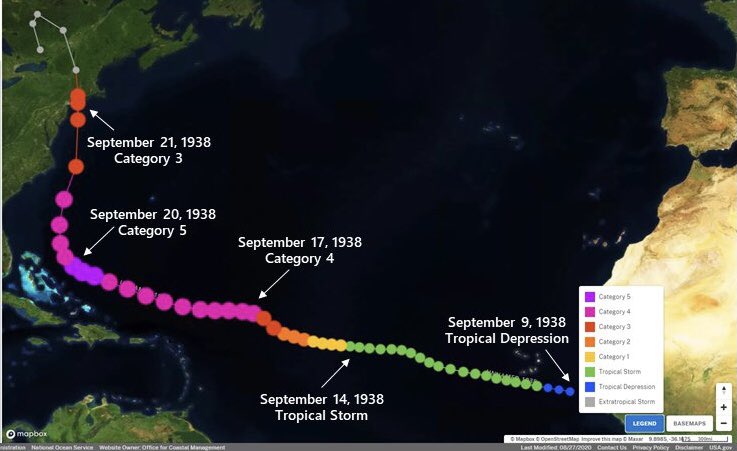
1938 New England Cane