

dbullsfan
-
Posts
155 -
Joined
-
Last visited
Content Type
Profiles
Blogs
Forums
American Weather
Media Demo
Store
Gallery
Everything posted by dbullsfan
-
latest wobble almost due north
-
about 20 miles north of Tampa.
-
are they not the same? I always just assumed that is where they got their info from. Showing my noobie side.
-
Not sure if that was directed at me but I by no means want to give off an indication the storm as a whole is a bust, the Tornado outbreak already has been bad and its only going to get worse for a ton of people as the day and night go on. My area specifically however seems to be getting spared, of course all this pending a wobble or two which can change things quickly.
-
Wild how much this has dropped in the last few hours. The wind forecast were all over 40 MPH and most over 50 MPH just a few hours ago. My question is did the organization of the storm change? Wasn't it supposed to be heavier winds to the Northwest of the actual land fall, is that no longer the case?
-
interesting what I'm seeing is the complete opposite looks like it's back to more of a NE movement of late and seems to be getting further and further away. Wind projections falling in line, seems like every time i refresh the wind forecast keep dropping at least here just north of Tampa. With the larger wind field I would have expected it to go up not down. Looking at the Wobble tracker it seems like a Sarasota LF could be in place and if the east turn is even more dramatic even south of there in play. Of course another wobble or two more North and Tampa comes back in play but it seems to be going well South at this point
-
I'm pretty sure its probably not the most reliable resource but just looking at the weather.com hourly forecast. For the last 24+ hours we have had a 5-6 hour period with winds 50-60 MPH. Now there isn't a single hour with winds even as high as 40. This is a huge change in terms of wind effects. I don't know how reliable/accurate those are but its a pretty significant change to the untrained eye.
-
Tornado's really starting to pop up now, up to 5 Warnings and 1 verified on the ground. That line just now coming onshore around Naples is pretty nasty.
-
Tornado on the ground West of Clewiston just North of 27 appears headed in the direction of the town of Benbow
-
Lutz, which is about 20-25 miles North of the Bayshore area in Tampa and 20-25 miles East of US 19/New Port Richey.
-
.
-
These guys having the time of their life so far but you can see standing water already starting to form and we are barely getting started. .
-
I 100% get this, unfortunately there isn’t much Met or more helpful comments in this thread, so when trying to find out if weakening or southern trends are going to affect certain areas. Like I was trying to ask it gets removed over there (which in storm mode again I understand) but it goes unanswered over here and so your kinda stuck not knowing where to ask the questions or if you ask them they just go unanswered which also sucks. .
-
Most consensus seems to think this turns east well before Tampa now. This line doesn’t seem likely at all. .
-
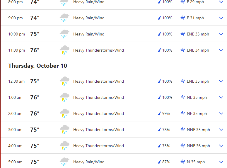
Been running pretty consistently here over the past few hours. Mostly light. Sounds from the main thread that the dry air is kicking in causing it to weaken although I’m not sold it’s just not beginning another EWRC but I’m a weenie compared to the Mets so I’ll take their word. Also not sold it’s 100% going south but that seems to be what most are saying. I’m still expecting some pretty strong conditions over the next 24 hours especially from 8 pm-4 am here but if it misses us I’m ok with that too. .
-
the eye getting smaller again is that good for inland and places not directly next to land fall but maybe 15-20 miles north? I'm thinking with landfall looking like its going further south the biggest impact here is going to be wind/rain but hopefully the smaller eye will help mitigate the wind impacts
-
This is a lot earlier than most models expected dry air to start impacting the storm correct? .
-
Not sure if its been mentioned yet but I'm a little worried that with the easy access to the coastline up and down the Tampa Bay area that this storm is going to bring out a lot of amateur storm chasers that don't have the proper training, knowledge or equipment to handle this kind of storm.
-
This almost looks/feels like a typhoon we should be seeing in Asia instead of Cane going into Florida .
-
Have they done a recon pass through the blob I NE of the storm, it looks nasty too as it’s on entity. That should get swallowed up at some point correct? .
-
Weenie ? But with Milton strengthening so quick and most likely still 48+ hours out, a EWRC seems almost a given but what are the chances it actually has time for 2 cycles, while this would naturally help lead to a lower max wind at land fall it would dramatically increase the size of the higher wind impacts. Thanks .
-
I feel like this storm can land fall as a Cat2 or even high end cat 1 and “underperform” to peoples expectations regarding wind speed and still be extremely devastating. The storm surge built up from a cat 4 isn’t just going to go away because of rapid intensification as it nears land fall. .
-
I’m just west of Wesley Chapel right off 75. Board that ish up in South Tampa, we aren’t in storm mode yet so forgive me for Banter but good time to gtfo and go hang out in Orlando for a few days. I got a feeling you don’t want to be anywhere near south Tampa or the Bay this week. No good feelings for this one .
-
wow already a TS....Milton gonna be a problem no matter where he hits at this point.
-
I'm normally the first one to come on here and joke about Tampa getting coned and avoiding storms but I don't know if we can avoid this one.


