StormChazer
-
Posts
1,193 -
Joined
-
Last visited
Content Type
Profiles
Blogs
Forums
American Weather
Media Demo
Store
Gallery
Everything posted by StormChazer
-

MO/KS/AR/OK 2020-2021 "Winter" Discussion
StormChazer replied to JoMo's topic in Central/Western States
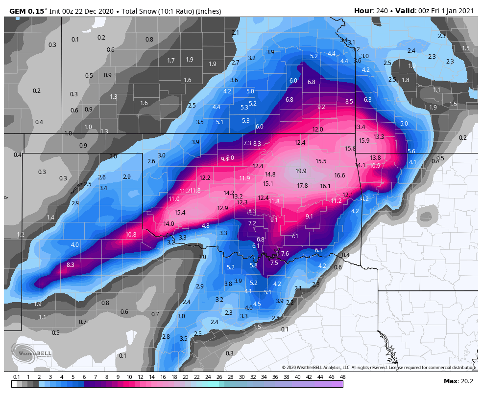
FWIW, here is the mean 48 hour snowfall of the Euro members yesterday at noon to midnight last night. BIG JUMP 12Z Yesterday 00Z Last Night -
MO/KS/AR/OK 2020-2021 "Winter" Discussion
StormChazer replied to JoMo's topic in Central/Western States
No kidding, and the euro didn’t do us many favors either. -
MO/KS/AR/OK 2020-2021 "Winter" Discussion
StormChazer replied to JoMo's topic in Central/Western States
Silly to analyze models with extreme scrutiny 7-8 day out, but I'm gonna do it anyways. Before the event, we(NE OK/SW MO/NW AR) are at or below freezing for about 18 hours, then the event starts, temps surge to upper 40's and low 50's, and then plummet back below freezing as it exits. Shallow cold air on this one, models do poorly in these situations and always underestimate the cold air's ability to linger, and want to let the warm air come push it out. In this scenario, cold air comes in, get's entrenched, then models want 30-40mph winds(gusts) from the south to come in and push it all out during the duration of the rain/snowfall only to have in come back in full force less than 24 hour after it gets pushed out. I'm not really buying that. That warm air would just go right over the top of the shallow cold air in that scenario. Which sets us up for sleet/freezing rain. But hey, I'm obsessing over 1 run of the euro 7 days out...so you know....there's that. -
MO/KS/AR/OK 2020-2021 "Winter" Discussion
StormChazer replied to JoMo's topic in Central/Western States
Yeah, that's....odd haha. -
MO/KS/AR/OK 2020-2021 "Winter" Discussion
StormChazer replied to JoMo's topic in Central/Western States
12Z GFS- What an absolute mess -
MO/KS/AR/OK 2020-2021 "Winter" Discussion
StormChazer replied to JoMo's topic in Central/Western States
Last night’s Canadian for laughs.
-
MO/KS/AR/OK 2020-2021 "Winter" Discussion
StormChazer replied to JoMo's topic in Central/Western States
Yeah, it went bonkers and I laughed it off. Then I saw the 00Z Euro.
-
MO/KS/AR/OK 2020-2021 "Winter" Discussion
StormChazer replied to JoMo's topic in Central/Western States
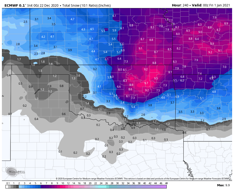
This is the mean snowfall for all 50 members on the Euro through noon on the 31st. Here is last night's 00z run vs the 12z run today. A promising trend. -
MO/KS/AR/OK 2020-2021 "Winter" Discussion
StormChazer replied to JoMo's topic in Central/Western States
Euro also picking up on it, albeit much much more tame. -
MO/KS/AR/OK 2020-2021 "Winter" Discussion
StormChazer replied to JoMo's topic in Central/Western States
Choo Choo! -
MO/KS/AR/OK 2020-2021 "Winter" Discussion
StormChazer replied to JoMo's topic in Central/Western States
Latest 12Z GFS supporting this... -
MO/KS/AR/OK 2020-2021 "Winter" Discussion
StormChazer replied to JoMo's topic in Central/Western States
Gfs isn’t showing it on simulated precip, but that’s looking like a New Year’s Eve(give or take a day) ice storm given those near 32 degree temps and rain. -
MO/KS/AR/OK 2020-2021 "Winter" Discussion
StormChazer replied to JoMo's topic in Central/Western States
-
MO/KS/AR/OK 2020-2021 "Winter" Discussion
StormChazer replied to JoMo's topic in Central/Western States
I'm reviving this statistical analysis I did last season to highlight how insane the snow drought here in NE OK was for those 5 seasons, but have updated it to reflect the past few days. I took the total snowfall from every season in 5 year intervals dating back to 1950. 1950/1951 - 1954/1955- 48.3 in 1955/1956 - 1959/1960- 64 in 1960/1961 - 1964/1965- 32.4 in 1965/1966 - 1969/1970- 60.6 in 1970/1971 - 1974/1975- 37.6 in 1975/1976 - 1979/1980- 48.2 in 1980/1981 - 1984/1985- 34 in 1985/1986 - 1989/1990- 57.6 in 1990/1991 - 1994/1995- 41.7 in 1995/1996 - 1999/2000- 37.2 in 2000/2001 - 2004/2005- 55.1 in 2005/2006 - 2009/2010- 61 in 2010/2011 - 2014/2015- 52.4 in 2015/2016 - 2019/2020- 11.8 in 2020/2021- Present- 5.2 in In just a matter of 3 days, we had almost half as much snow as we did in the past 5 seasons combined! We average 45.85 inches every 5 seasons, so before the crazy snow drought, we were overperforming the previous 15 years! Now that we got the monkey off our back, I'm confident in a return to normal from here on out, but we shall see! -
MO/KS/AR/OK 2020-2021 "Winter" Discussion
StormChazer replied to JoMo's topic in Central/Western States
I'm reasonably happy right now with the Christmas forecast. We've got very cold air making it's way down and a storm system swinging through. By that logic, the "hard part" is out of the way. Now we just need some small adjustments to make snow on Christmas Eve/Christmas a reality. -
MO/KS/AR/OK 2020-2021 "Winter" Discussion
StormChazer replied to JoMo's topic in Central/Western States
It’s almost as if the 00Z GFS read my last post... -
MO/KS/AR/OK 2020-2021 "Winter" Discussion
StormChazer replied to JoMo's topic in Central/Western States
All I'm going to say about Christmas 10 days out is this.... Cold Air....CHECK Storm system coming through the plains...CHECK Now if we can just get that system to come south and slow up, we'd be in business. A man can dream about a white Christmas, but even some flurries would be mood setting. -
MO/KS/AR/OK 2020-2021 "Winter" Discussion
StormChazer replied to JoMo's topic in Central/Western States
This!! It's very pretty, nothing too heavy, but definitely not just "flurries". It's enough up here in Owasso to turn the melted patches light again, and the cars and roofs white again. -
MO/KS/AR/OK 2020-2021 "Winter" Discussion
StormChazer replied to JoMo's topic in Central/Western States
If I can't get a white Christmas, then give me a cold one! -
MO/KS/AR/OK 2020-2021 "Winter" Discussion
StormChazer replied to JoMo's topic in Central/Western States
Moving on... It's like a dream getting to talk about potential snow back to back like this. I could get used to it. Extended HRRR. Aside from the NAM3k, NE OK looks to get about 1-2(more as you go west). More of a central/western OK storm. I'm thinking OKC will get a nice bullseye of around 4 inches based on the other models. I'll take my 1-2 inches in Tulsa to mask today's melting. -
MO/KS/AR/OK 2020-2021 "Winter" Discussion
StormChazer replied to JoMo's topic in Central/Western States
I figured it out. I reached my limit Here. I think the the 3KNAM handled this pretty well in our area, and the GFS did a great job as well once it was a few days out. Euro was consistent as always.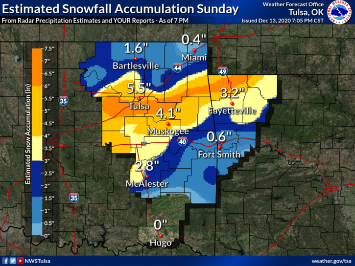
-
MO/KS/AR/OK 2020-2021 "Winter" Discussion
StormChazer replied to JoMo's topic in Central/Western States
Not sure why I can't attach the image file, but looks like Tulsa got 5.5 inches. The drought is over!! -
MO/KS/AR/OK 2020-2021 "Winter" Discussion
StormChazer replied to JoMo's topic in Central/Western States
You spoke it into existence! Better late than never! -
MO/KS/AR/OK 2020-2021 "Winter" Discussion
StormChazer replied to JoMo's topic in Central/Western States
Already got around 2-3 inches here in Owasso. -
MO/KS/AR/OK 2020-2021 "Winter" Discussion
StormChazer replied to JoMo's topic in Central/Western States
These flakes are huge and coming down hard! Can’t imagine they don’t add Tulsa to the Winter Storm Warning with their band setting up over the metro.