

NEG NAO
-
Posts
6,930 -
Joined
-
Last visited
Content Type
Profiles
Blogs
Forums
American Weather
Media Demo
Store
Gallery
Posts posted by NEG NAO
-
-
1 minute ago, donsutherland1 said:
The heaviest precipitation is finished by 204 hours, even as it's cold enough for snow. Hours 204-210 might be sufficient for 1"-2", if the model output is right. But at this point in time, it's speculative given the lack of other support and timeframe involved. My point is that the 7.8" total is unlikely without dramatic changes.
agree we don't have any idea this far away the details about how this storm is going to actually track and redevelop way too early for those details.........
-
 2
2
-
 1
1
-
-
1 minute ago, donsutherland1 said:
Some points about the 12z GFS's Day 8-9 Storm:
1. The GFS is in a timeframe where skill is low
2. The GFS lacks support from other global models and the ensembles
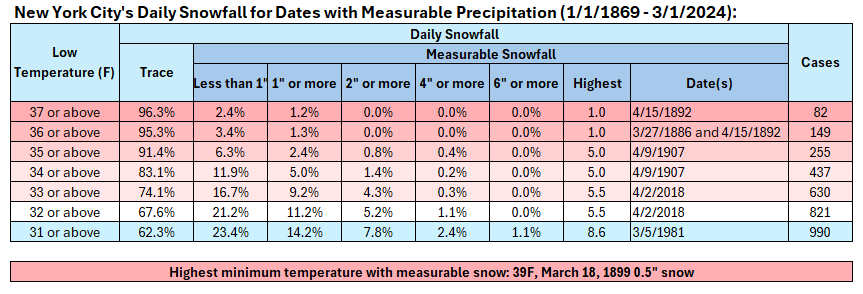
3. The GFS's soundings show readings remaining above freezing throughout the stormNew York City's Above Freezing Snowfalls:
In short, unless there is more than a marginal air mass and strong support from the other guidance, one should be skeptical of the snowfall amount (7.8") shown on the GFS. Ratios for any snow would be far lower than 10:1.
but the GFS and CMC have it cold enough aloft at 850 at hour 204 as I illustrated a couple posts above - and we already have had a storm this winter with ratio;s closer to 5:1 and surface above freezing
-
1
-
1
-
-
the CMC even has it cold enough at 850 when the GFS shows snow But the surface is above freezing


-
1
-
-
22 minutes ago, cleetussnow said:
The last time people humped the warm icon I got 9 inches of snow and the GFS outperformed it and everything else including the euro when it shit itself inside of 48 hrs.
the reason the GFS is showing snow here is that the storm redevelops off the coast and 850 below freezing but the surface temps are above freezing


-
1
-
1
-
-
11 hours ago, LibertyBell said:
We're in for some bad times if what happened last June repeats itself.
if we experience mainly south - southwest flow and primarily winds from that direction at various levels of the atmosphere or an onshore flow the same smoky sky conditions if the fires develop in Canada will not reach our area as much as last years flow allowed it too......
-
 1
1
-
-
3 minutes ago, NEG NAO said:
lol - no real warm weather is in site yet............
there will be 1 -2 day windows for frozen in March and early April just like many winters .
-
2
-
1
-
-
2 minutes ago, snowman19 said:
Op GFS lol It’s over dude. JB just called it quits. It’s warm as far as the eye can see
lol - no real warm weather is in site yet............
-
1
-
1
-
-
5 hours ago, Stormlover74 said:
Even JB threw in the towel

So now we can expect at least a few more opportunities for frozen precip here March and April........looking at the 0Z GFS - it is possible IMO

-
1
-
1
-
-
3 minutes ago, donsutherland1 said:
No. There was a colder more stable temperature regime. A natural cycle and increasing background warming are involved this time around. Already, areas further south in the Mid-Atlantic region have seen a long-term decline in seasonal snowfall. NYC's winters are nearing thresholds where the transitions took place farther south.
In terms of winter warmth, nothing has compared to the 2000s. The current winter will likely see yet another mean temperature of 40 or above. Prior to the 2000s the only such winter occurred in 1931-32. There have been five winters with such warmth in the 2000s. Winters 2022-23 and 2023-24 will become the first case of two consecutive winters with a mean temperature of 40 or above. Such warmth typically results in fewer opportunities for snowfall. Absent big storms, snowfall totals wind up lower.
Is this the main reason NYC has only 7.5 inches total snowfall this winter and surrounding metro areas have more and much more in other areas including mine with close to 2 feet so far this season and we are south of the city?
-
2 minutes ago, LibertyBell said:
Yes, the park can't be trusted for anything anymore-- not temperatures, wind speeds or snowfall measurements.
JFK has had issues over the years too (mostly on extremely windy snowstorms where they undermeasure.)
I thought the 93-94 snowfall totals were decent because it's the first time in my life I had seen a 50"+ winter. Back in the mid 90s no one ever told us what the other totals were, I only found those out a decade later.
You can add Newark to that list they seem to always be warmer then every other location sometimes.......
-
2
-
1
-
-
10 minutes ago, bluewave said:
The 50s and 80s were much colder than the present era. Less snowy winters in those years were still cold by todays standards. They were mostly the result of unfavorable storm tracks. This is the first time we are getting a combination of too warm for snow for numerous storm occasions plus unfavorable tracks.
I don't think we have been experiencing the lower then normal seasonal snowfall region wide long enough to come to any decisive conclusions. I agree about "too warm". What happens with the snowfall theory when we get another 5 - 10 year period of above normal ? And as witnessed this season so far that might not include NYC Central Park because there are numerous factors affecting its ability to accumulate snow .............
-
1 hour ago, donsutherland1 said:
Yes. NYC is likely in the early stages of a transition to lower seasonal snowfall.
Do you think they were saying that back in the early 1950's and the 1980's ?
-
48 minutes ago, MJO812 said:
Too early
March has been our snowiest month
Easter is on March 31st this year - "I'm dreaming of a White Easter"........
-
1
-
-
8 minutes ago, SACRUS said:
Cold day but did make it to 43 quickly down to 37
and melted a few more inches of snow - now left with less then 2 inches and many bare spots
-
1
-
-
20 minutes ago, eduggs said:
IMO it would be better if the northern stream wave and associated surface low diving through southern Canada were further southwest (and diving southward into the US), allowing a phase with the system moving towards the eastern US coast. If there is a surface low northeast of us, it will be very difficult to form a meaningful SLP along the east coast.
Unfortunately I think the big storm idea is becoming very unlikely.
the last storm was not a big storm it was a weak fast moving mid lat. storm that had a couple of heavier bands. There was enough cold air because that Thursday night LP to the north passed and dragged in just enough cold this coming system late week setup is similar but the players are not in the same spot as before as of now......all about timing
-
2
-
-
17 minutes ago, jm1220 said:
Look about 300 miles north and you have your issue. You want a big H there not L. Cold air comes in behind the storm as shown-from that we’d be dealing with the warm air coming in ahead of that Quebec low. There’s time for changes but not encouraging so far.
yes I saw that - that low needs to be further east just like the other night dragging down cold air in back of it to set the stage for the follow up storm.....
-
3
-
-
28 minutes ago, LibertyBell said:
Yeah that's why I put the - after the C lol
It's hard to give a winter a D when there are two snowfalls of 4 inches plus.... in the same week!
this month will end up with avg temps much above normal and snowfall above normal in some areas in NJ especially
-
3
-
-
29 minutes ago, LibertyBell said:
it's definitely been melting here today with the strong sunshine
same here many bare spots showing up here - and temps above freezing 37 degrees at 1:30 pm
-
1
-
-
2 hours ago, RU848789 said:
So somehow in what has been a crappy winter for many we've overperformed on almost every storm... the 11.25" yesterday brings me to 24.5" for the season which is actually ahead of normal for this date. It's just nuts that we're 17" ahead of CPK, just 25 miles to our NE. I'll take it and run lol.
how did you get to 24.5 ?? I am only a few miles from you got 9" yesterday bringing my total to 17".........
-
1
-
-
1 hour ago, forkyfork said:
i was in piscataway last night and yards that got sun were down to about 3"
i am 10 miles east of their and the same result here - combination of snow settling - sun melting it above freezing all day and wind - by mid week most of it will be gone except for shady areas and snow piles........
-
0Z EURO - perfect storm track with no cold air in place prior - need the storm to slow down west of us and cold air get here first

-
2
-
-
1 minute ago, LibertyBell said:
no just lots of blowing and drifting today, it doesn't matter much anyway it'll be gone in a few days either way.
true - a week from right now not a trace left unless the late week system delivers more snow which doesn't look likely as of now........
-
1
-
-
who else lost at least half of their snow cover today ?- started with 8 1/2 inches down to 3 -4 with bare spots showing up surrounding larger trees........
-
6 hours ago, Irish said:
Yup, the last 2 storms were misses by the models and in some cases really bad misses.
And I wasn't saying that it's likely and I84 storm, just saying what the title reads.
models are all over the place for this late week event - still a work in progress with timing issues but cold enough air close by

-
4
-
March 2024
in New York City Metro
Posted
no one was expecting the April 1982 Blizzard after a mild period previous to the storm
A Severe April Blizzard Stunned The Northeast in 1982 | NY NJ PA Weather