KoalaBeer
-
Posts
623 -
Joined
-
Last visited
Content Type
Profiles
Blogs
Forums
American Weather
Media Demo
Store
Gallery
Everything posted by KoalaBeer
-
Winter doesn’t even start until Dec 21
-

Winter 2020 New England Banter and General Obs
KoalaBeer replied to CapturedNature's topic in New England
LWM 18f at midnight while BED is 8f. I have a hard time buying that. https://forecast.weather.gov/obslocal.php?warnzone=MAZ005&local_place=Wilmington MA&zoneid=EST&offset=18000 -
And people here were complaining about heated walkways at ski areas...imagine they started clearing the parking lots with this thing. Anyways our eventual system is impressive on the west coast, not every day you see a 974mb pressure in OR in November. https://www.wrh.noaa.gov/mesowest/timeseries.php?sid=K4S1&num=72&banner=gmap&raw=0&w=325
-
I was up by Tenney today on the way home from the Whites and it reminded me I need to check it out this year as well! If I recall correctly there is no snowmaking since they re-opened? All natural which is pretty sweet.
-
Ragged Mt is not nearly as big as places like Cannon or BW but still offers some great terrain. There trees are actually awesome and they get sneaky dumped on a lot. There season pass is only $349. I typically grab one even if I have another pass elsewhere. Not a bad drive from Lowell either, probably an hour forty-five minutes and it's pretty nice that your not on the highway the whole time IMO.
-
FYI this airs at 7:30 EST on The Weather Channel.
-
Big ridge on euro but trough coming across the central conus will eventually turn it. Also notably weakens TD 10 as it approaches the Bahamas.
-
Fun conditions at this Buoy! 39ft wave height earlier this morning. https://www.ndbc.noaa.gov/station_page.php?station=44011
-
Posted this over in the Dorian thread but figured I'd post it up here as well. Some wild footage from Hope Town via Jim Edds. Canada sure looks like it's going to get whacked. Quite the impressive structure for where Dorian is in the Atlantic. I'll probably take a drive up to Salisbury beach tomorrow to at least check out the surf.
-
According to James Reynolds he probably didn't. If I recall correctly they have been on some chases together in the WPAC so it's about as a reliable source we can get at this point.
-
Aerial footage coming out of Abaco now is pretty unreal.
-
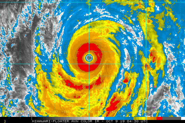
Dorian racking up the ACE for the Atlantic and still has a way to go. Should join the pretty exclusive list of Hurricanes producing more then 40 ACE. Year Storm# Name Dates TC Active Max Wind (kts) MSLP (mb) Named Storm Days Hurricane Days Major Hurricane Days Accumulated Cyclone Energy 2019 1 ANDREA 5/20-5/21 35 1006 0.75 0.00 0.00 0.4 2019 2 BARRY 7/11-7/14 65 993 3.50 0.25 0.00 3.3 2019 3 CHANTAL 8/21-8/21 35 1009 1.00 0.00 0.00 0.5 2019 4 DORIAN 8/24-9/3 160 910 10.00 6.00 4.00 35.0 2019 5 ERIN 8/28-8/28 35 1005 0.75 0.00 0.00 0.4
-
Ya it would have been close I think. Plenty of videos out there that seem to show a 20ft plus storm surge and thats what the NHC put out in there warnings as well. Hopefully he checks in at some point today. Here's the map I pulled the elevation from.
-
Here is the location on google maps if I'm right. https://www.google.com/maps/place/26°32'23.0"N+77°04'47.0"W/@26.5402011,-77.0780259,2958m/data=!3m1!1e3!4m5!3m4!1s0x0:0x0!8m2!3d26.5397222!4d-77.0797222
-
From what I've gathered this is where he was located. Roughly ~25ft ASL. Looks like a solid structure but appears like its only 1 story tall. He's on this persons search listed as not found but who knows who reported that. https://docs.google.com/document/d/1M9wVx_Krgzb2cycTOGF4ZsS5JDrvRGwggCblUGtq6II/mobilebasic "Morgerman, Josh (Central Abaco Primary School, Marsh Harbour, @iCyclone)" I'd take it with a grain of salt for now. Josh knows what he is doing and like you said in previous extreme storms he's gone days without contact.
-
Looking at the ensembles it looks highly unlikely. It is just really tough to sneak a storm into New England coming up from the southeast US like that. I can see Canada happening though.
-
Station went down before the worst hit. https://www.jma.go.jp/en/amedas_h/yesterday-93062.html?areaCode=000&groupCode=65
-
I'm not so sure about that. The radar suggests they only clipped the outer part of the eye wall. I'm sure it was still a rough ride but not as hellacious as that inner eye wall.
-
How about that for a trochoidal wobble.
-
Fani is putting on a hell of a show right before landfall CI# /Pressure/ Vmax 6.0 / 935.7mb/115.0kt Final T# Adj T# Raw T# 6.0 6.2 7.2
-
Not looking good. Look at all the people trapped on roofs escaping the surge/flooding. https://mobile.twitter.com/miguel_carreiro/status/1107695723506737154
-
March 12/13/14 Blizzard/Winter Storm/WWA etc
KoalaBeer replied to Bostonseminole's topic in New England
In a similar conundrum myself here in Methuen. 28.3" here and 27.3" in Dracut on the NWS statement and the Methuen one was a trained spotter. I sit right on the line and couldn't find anywhere around my house over 19 inches with 10 plus measurements taken. Definitely interesting. -
March 12/13/14 Blizzard/Winter Storm/WWA etc
KoalaBeer replied to Bostonseminole's topic in New England
What would you say you have on the ground? Saw on the news 15" in Dracut but I got 9.5" here in Methuen right on the Dracut line. Been sitting barely outside that heavy band all day but really starting to rip now. Wondering if the gradient is that tight from here to Nashua.