cardinalland
-
Posts
481 -
Joined
-
Last visited
Content Type
Profiles
Blogs
Forums
American Weather
Media Demo
Store
Gallery
Everything posted by cardinalland
-
i saw some purple and green in the sky from my phone camera (and a very faint purple-pink glow in the northern sky with my eyes) from croton harmon NY
-
Mid 50s behind the backdoor here in southern Connecticut
-

April 8, 2024 Eclipse
cardinalland replied to Cat Lady's topic in Weather Forecasting and Discussion
I saw them in Lyndon VT. SO cool. -
I like the ridge axis just west of new england. a good sign for this area although not a guarantee
-
looks like 7-8 inches on the ground in new haven. in line with the spotter report of 8”. snow stopped just after 1 and there’s already a little melt commencing. nice storm though
-
3.8 in new haven. 1.4 in last hour
-
heavy rates with low visibility and more on the way. everything snow covered including the street. everyone’s thanking this pope fella so i’m gonna thank him too
-
wow ripping snow in new haven. pretty heavy. gonna go out to measure in a few.
-
i remember a lot of folks saying “winter is over” around january 15th 2018 and look at what we got next 2 weeks do look AN though, only a tiny window around the 30th for potential snow
-
about 0.6” in new haven. accumulated on most surfaces, except those with a bucketload of salt on them…
-
At least it's something - Jan 16th Snow/Sleet/Ice OBS Thread
cardinalland replied to The 4 Seasons's topic in New England
definitely verifying in new haven. we’ve got 0.2” of ice on top of the snow and it is rock solid -
At least it's something - Jan 16th Snow/Sleet/Ice OBS Thread
cardinalland replied to The 4 Seasons's topic in New England
there’s a solid layer of ice here in new haven now on untreated surfaces. the ice threat was definitely real -
i’m seeing -30s for lows friday and saturday in edmonton. i think that could do the job
-
Two Mdt to high impact events NYC subforum; wknd Jan 6-7 Incl OBS, and mid week Jan 9-10 (incl OBS). Total water equiv by 00z/11 general 2", possibly 6" includes snow-ice mainly interior. RVR flood potential increases Jan 10 and beyond. Damaging wind.
cardinalland replied to wdrag's topic in New York City Metro
(national) blend of models i believe- 3,610 replies
-
- 2
-

-
- snow
- heavy rain
- (and 5 more)
-
I am on the UWS and did not notice anything from this earthquake. but I don't recall ever feeling the shaking from one so i don't know what to expect
-
UKMET output looks fairly similar to CMC. less amped than the EURO 00z which is ideal (at least up to h144)
-
yep, and i'm intrigued by the period after 1.10.24 as well. looking like a big change from the nationwide decembtorch
-
it would be interesting if a storm formed off that cold front, i know that kind of setup has delivered before
-
1/10 storm is a rainer to mainer on GFS. high in a worse location
-
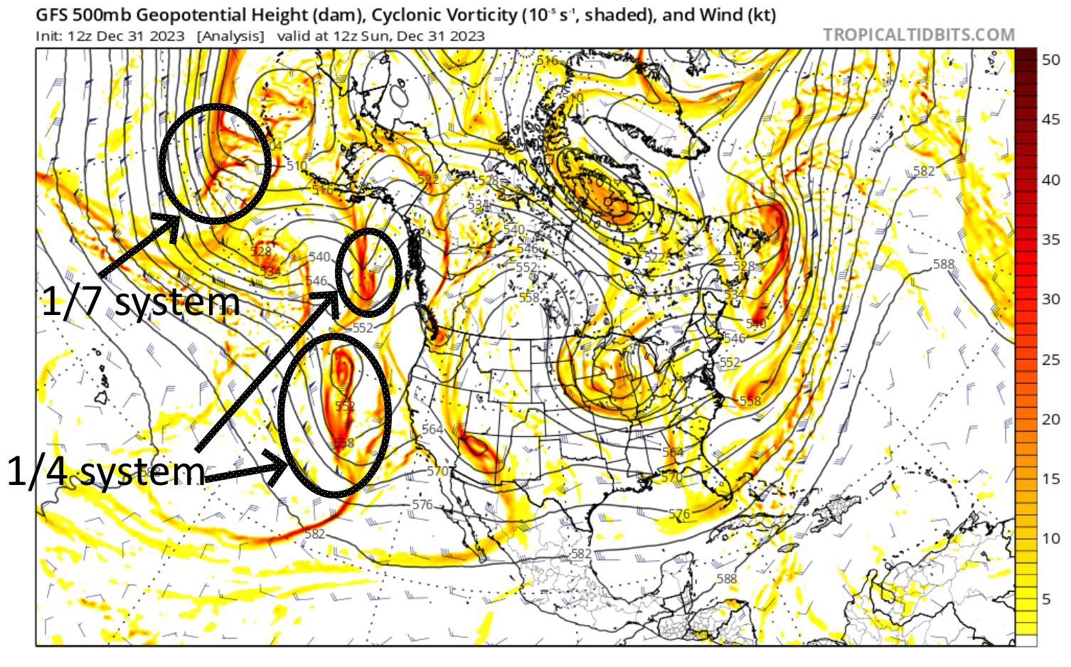
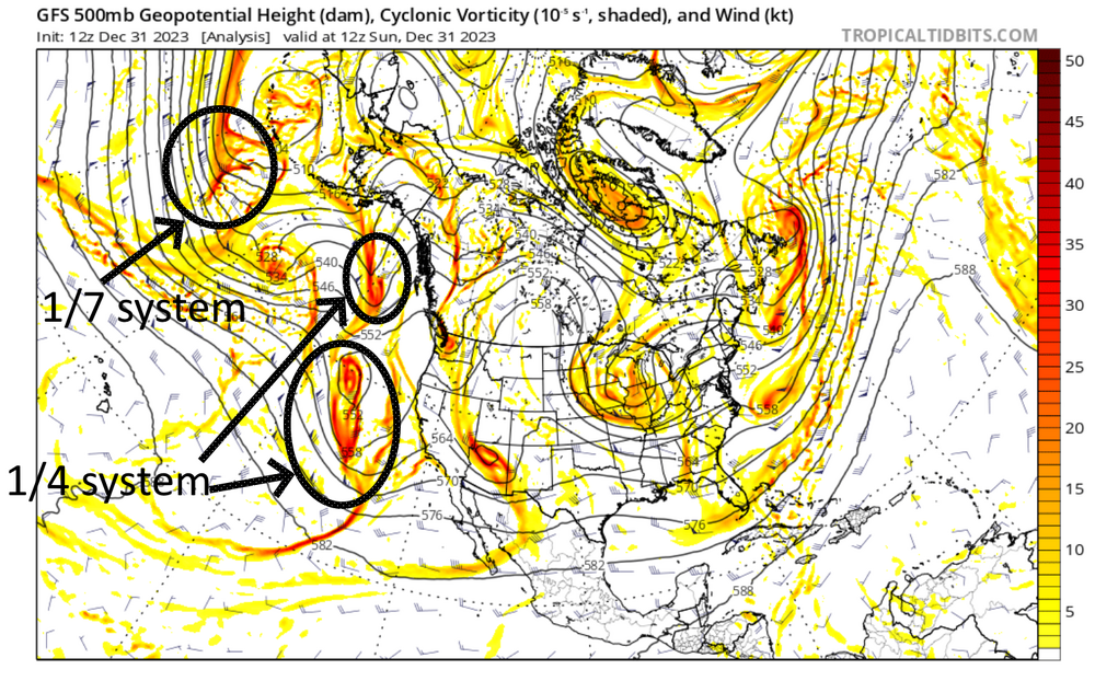
traced the storms back to the present/hour 0 and they are still quite far away at present. don't know enough to determine how this impacts prediction, but wanted to share anyways
-
verbatim 12z GFS crushes NNJ NYC SNE. gotta keep an eye on that north trend though
-
storm more amped through GFS hour 165. hopefully this doesn't become another cutter
-
there's a legit 50-50 low on GFS for 1.7.24
-
beautiful spring day today
-
last strong niño wasn’t too far off in most of the region. definitely less snow in 2023 up north though. and in N Central US