
cardinalland
-
Posts
481 -
Joined
-
Last visited
Content Type
Profiles
Blogs
Forums
American Weather
Media Demo
Store
Gallery
Everything posted by cardinalland
-
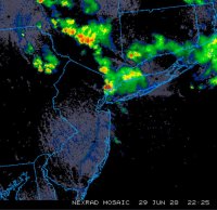
 all i can think of is, this storm is flying. looking at the radar, i do think the next 2 hours are most critical/intense for our region. but there's still a lot of showers behind
 -
Tracking February 6. Light to moderate event potential
cardinalland replied to Typhoon Tip's topic in New England
i like your pfp. I used that image for my super bowl party invitation haha. Weather related my area has been warming quickly since the change-over to sleet. PWS in the area are showing 28-31 now. but the precipitation will get a lot spottier after about 10:30am. -
Tracking February 6. Light to moderate event potential
cardinalland replied to Typhoon Tip's topic in New England
1” on the dot in new haven as of 8:15am. we seem to be alternating between sleet and snow. i was thinking about 2” of frozen precip, and we seem very likely to get close. -
Tracking February 6. Light to moderate event potential
cardinalland replied to Typhoon Tip's topic in New England
looks like we changed over to sleet in the last 5 minutes. new haven CT -
Tracking February 6. Light to moderate event potential
cardinalland replied to Typhoon Tip's topic in New England
i think the sleet/ZR risk is p significant for this one. particularly in the valleys and in the CNE region. that warm tongue is racing forward while there's not so much movement at the surface, and a small coastal low popping. -
ended with about 3" in new haven. local jackpot it seems. with the weather coming this snow should stick around for a while.
-
snow line is collapsing to their NW but pensacola should have at least 2-3 more hours to add to their total
-
steamrolla in pensacola rippin in destin crusha in pascagoula sky fell in slidell snowed in in houston snow you get in lafayette snows well in mobile big freeze in chattahoochee
-
you got a helluva temperature gradient down there
-
don't have to deal with any mixing issues down in... new orleans...
-
1/21-1/22 Winter Storm OBS Thread
cardinalland replied to metalicwx367's topic in Southeastern States
and there's hours more of precip to come... we are witnessing history -
solidly polar airmass, alright wind direction, decent snowpack, but kind of weak winds. i think all suburbs make it to single digits and i'm gonna say 2/3 of city stations do too
-
coming down well in new haven. maybe 0.5” and sticking to all surfaces. should make it to 3, at least, with how the radar’s looking
-
shloppy mix in new haven
-
New England Winter 2024-25 Bantering, Whining, and Sobbing Thread
cardinalland replied to klw's topic in New England
-
a good thing is the pattern is fairly long-lasting and the AO dump keeps things cool-ish across the continent for a while. many chances for a storm to pop up
-
Snowfall NYC subforum Jan 6 and OBS if needed
cardinalland replied to wdrag's topic in New York City Metro
interestingly model evolution has this storm's energy feeding into the massive trough off newfoundland to create even more confluence and thus to push the next storm even further south -
Snowfall NYC subforum Jan 6 and OBS if needed
cardinalland replied to wdrag's topic in New York City Metro
in the current climate regime i'd definitely rather be staring at suppression city than last week's continental torch. more to work with -
having the coldest departures to our south and a big fat trough east of us is a suppression city look... I would want one of these things to moderate for a better outlook
-
i'm rooting for our southern friends
-
thunder on NYE un-fuckin-believable
-
verbatim the storm track looks pretty suppressed to the south right now with the main temperature gradient being well to the south. plenty of time for this to change though and a coastal could spring out of the warm Gulf as well
-
this is a rare case where forecast highs/lows have kept going down as the event approaches… i’m getting 14 point and click for manhattan tonight night now and some forecasts are lower
-
first flakes in upper manhattan


