BNAwx
-
Posts
302 -
Joined
-
Last visited
Content Type
Profiles
Blogs
Forums
American Weather
Media Demo
Store
Gallery
Everything posted by BNAwx
-
I'm in one of those whiteout spaces in Davidson Co. Hopefully that'll change a little by next week.
-
Wouldn't be surprised to see OHX issue a WSW tomorrow if the rest of the 0z models come in favorably.
-

February/March 2021 - Frigid or Flop? Pattern/Longterm Forecast Thread.
BNAwx replied to John1122's topic in Tennessee Valley
Awesome. Thanks! Hopefully we'll see the eastward trend continue. -
February/March 2021 - Frigid or Flop? Pattern/Longterm Forecast Thread.
BNAwx replied to John1122's topic in Tennessee Valley
Holston...can you tell how these ensemble members compare to the 0z run? Just curious to see if they trended slightly east as well. -
That looks like my boom box from 1985.
-
February/March 2021 - Frigid or Flop? Pattern/Longterm Forecast Thread.
BNAwx replied to John1122's topic in Tennessee Valley
Unfortunately, like most systems this winter, I don’t think we’ll get a good consensus until about 3 days before the even so I’m sure we’ll see more waffles over the next couple of days. I can see justification for more of a NW solution as well as a more southerly/easterly track. -
February/March 2021 - Frigid or Flop? Pattern/Longterm Forecast Thread.
BNAwx replied to John1122's topic in Tennessee Valley
True. That's one factor that can definitely point to a more NW track. Frankly, I'm about 50/50 with this whole setup. Anthony Masiello had a good tweet recently about the movement of the TPV as well that might shed a little more light on how the models might progress. Who knows....? -
February/March 2021 - Frigid or Flop? Pattern/Longterm Forecast Thread.
BNAwx replied to John1122's topic in Tennessee Valley
I'm not so sure the blocking has vanished or will vanish at the timeframe we're looking at (2/15 - 2/17). Again, I could be wrong. I'll be anxious to see where it ultimately ends up.
-
February/March 2021 - Frigid or Flop? Pattern/Longterm Forecast Thread.
BNAwx replied to John1122's topic in Tennessee Valley
It could be right but I still believe these models will correct south and East somewhat as we get closer to the event. That’s been the seasonal trend and I’ll rise with it until it bucks me off. LOL! -
February/March 2021 - Frigid or Flop? Pattern/Longterm Forecast Thread.
BNAwx replied to John1122's topic in Tennessee Valley
Great example. And depending how cold the upper levels are, that could mean the difference between ice, sleet or snow...or just plain rain. -
February/March 2021 - Frigid or Flop? Pattern/Longterm Forecast Thread.
BNAwx replied to John1122's topic in Tennessee Valley
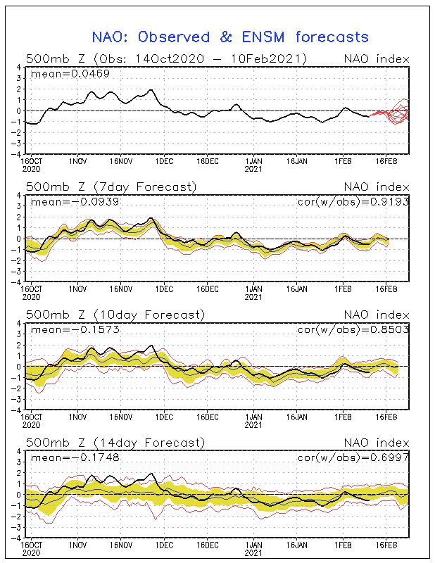
Interesting tweet from Anthony Masiello this morning....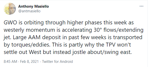
-
February/March 2021 - Frigid or Flop? Pattern/Longterm Forecast Thread.
BNAwx replied to John1122's topic in Tennessee Valley
I also like to keep in mind the seasonal trend. Thanks to the -NAO, the SER has been beaten back after showing up strongly on modeling in long lead times. I think persistence is the key here. I guess "dance with the one that brung ya'" is my way of looking at it. -
It’s still a slight mix but it’s coming down at a moderate clip. Might get a coating if we can hold on for a bit longer. I’ll consider that a win so far this year...
-
Biggest flakes I’ve seen in quite a while...
-
Finally got some fatties coming down in Hermitage, TN!
-
February/March 2021 - Frigid or Flop? Pattern/Longterm Forecast Thread.
BNAwx replied to John1122's topic in Tennessee Valley
Can you imagine what the old DGEX would look like? -
February/March 2021 - Frigid or Flop? Pattern/Longterm Forecast Thread.
BNAwx replied to John1122's topic in Tennessee Valley
To be on the safe side, I’ll prolly go today to make sure I’ve got gas for the generator... -
February/March 2021 - Frigid or Flop? Pattern/Longterm Forecast Thread.
BNAwx replied to John1122's topic in Tennessee Valley
It’s always possible but take these outputs with a grain of salt. It’s simply going to depend where the arctic boundary sets up shop. Ice for someone is almost a given. Models will struggle until we get much closer. -
February/March 2021 - Frigid or Flop? Pattern/Longterm Forecast Thread.
BNAwx replied to John1122's topic in Tennessee Valley
Yeah. Not a good look. Might need to gas up the generator we got after the tornadoes last March... -
February/March 2021 - Frigid or Flop? Pattern/Longterm Forecast Thread.
BNAwx replied to John1122's topic in Tennessee Valley
With that flow, it might not be done with the mischief yet... -
I wouldn’t be surprised if this system ticks further west still.
-
I believe there could be even more changes with this one...even though we’re now in the mesoscale model range.
-
February/March 2021 - Frigid or Flop? Pattern/Longterm Forecast Thread.
BNAwx replied to John1122's topic in Tennessee Valley
My favorite look is an arctic boundary with that WSW orientation...as long as it’s far enough south to allow a deeper penetration of an arctic air mass.