Henry's Weather
-
Posts
1,729 -
Joined
-
Last visited
Content Type
Profiles
Blogs
Forums
American Weather
Media Demo
Store
Gallery
Everything posted by Henry's Weather
-
 hopefully you mean jist... I'm rooting for your analysis to be correct haha
 -
Uncanny to see watches out for Mid-Atlantic when we won't see them hoisted here for a day or two. Slow moving systems seem pretty rare these days.
-
I was hoping to disguise my message from several WOR folks
-
decent amount of Junos there. High end potential seems to still be on the table.
-
Seems to really thump for about 12-18 hours with lingering Currier and Ives type stuff afterwards for another 18
-
One would think that QPF output is too low given the track and the speed. Or is this just weenie goggles?
-
Ukie and GEM are 1-2 feet verbatim for i-95, yes?
-
WPC bullish:
-
Correct me if I'm wrong, but there seems to be a similar level of traffic downstream between both of these events, regardless of calculated NAO indices. We didn't have the omega block in 2015 though.
-
this looks like a rip-off version of one of those day 3 euro runs for Jan 2015, which jacked Trenton-NYC and gave Eastern Mass the occluded snows. Probably chop off 30% of those totals though.
-
Would rather have the shitty scenario on the gfs rather than the EC.
-
not to be a weenie but I think that run would be like 15-25"+ verbatim for ENE based on H5 track and speed.
-
Info I don't like is bad and shouldn't be said .... okay
-
real enough for you, @Snowcrazed71?
-
Pessimism/scepticism is wayyy better then blind optimism at the d4-5 range
-
We should still be leaning heavily on ensembles at this point, right? The energy doesn't come ashore until midday Friday, so we don't know the exact level of detail the deterministic model approach would require. Obviously I'm hoping for a more potent, concentrated shortwave.
-
Heh, some weenie CANSIPS maps incoming:
-
Apparently
-
Let NYC people get excited before the inevitable progressive trend at the end....I hope.
-
Bad H5 low placement.
-
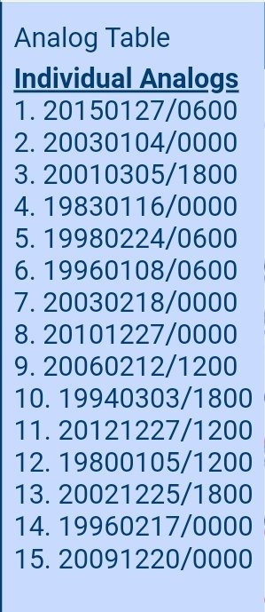
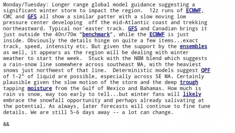
BOX disco
-
non-qpf seems fine to me?
-
What I've heard is true, you really do have a jackpot fetish! Here on the coast, I'm usually fine with 60% of what ORH gets.
-
Precisely my point, you'd be grateful for your position outside the i-95 belt if you moved out here a year. Just saying. Also, you think I've done better than you these past 3 winters? December 2019 I pulled a fat 5 inches, probably only had an inch or two more than you in this year's December storm. March 2019 I doubt I had more than you. There's no contest who retains pack better. Lol
-
maybe relative to average, but I average 45 while Wilmington/Methuen probably averages 55-60. Plus, you got that 31 inches in March 2018.