CheeselandSkies
-
Posts
3,143 -
Joined
-
Last visited
Content Type
Profiles
Blogs
Forums
American Weather
Media Demo
Store
Gallery
Everything posted by CheeselandSkies
-

2024 Short/Medium Range Severe Weather Discussion
CheeselandSkies replied to Chicago Storm's topic in Lakes/Ohio Valley
SPC put out a pretty large Day 5 areal highlight this morning, for a good chunk of MN/WI. I'm thinking this is mostly for bowing MCS possibility Sunday night. -
2024 Short/Medium Range Severe Weather Discussion
CheeselandSkies replied to Chicago Storm's topic in Lakes/Ohio Valley
Surprised only three reports on the SPC page. Not as prolific as I expected, but what did occur was definitely impressive. From longtime chaser Dan Robinson: -
2024 Short/Medium Range Severe Weather Discussion
CheeselandSkies replied to Chicago Storm's topic in Lakes/Ohio Valley
Beryl proved an efficient producer yesterday, and is expected to remain so today. 10%/Enh risk now up for a portion of the western OH Valley. -
Beryl proving to be an efficient tornado producer. CAM solutions yesterday hinted at this, and SPC responded by introducing a (somewhat unusual for TC-driven events) 10% area.

-
Surprised MKX is so bullish on rain chances tonight/tomorrow morning since both HRRR and 3KM NAM have southern WI dry during that period.
-
The Wisconsin River basin has seen multiple severe flood events in the last 15-20 years; starting with 2007-'08 and again in 2018. The Mid-Continent Railway Museum in North Freedom (along the Baraboo River) got flooded in each of those. I'm concerned that that area seems to be getting bulls-eyed a lot in the recent rounds of precip, as well.
-
06Z HWRF takes Beryl into relatively remote regions of the Quintana Roo coast, near the Belize border, but everything north of there is still very much in play. For our 1st anniversary in 2022 my wife and I spent a few days at a resort in Puerto Morelos, a little town south of Cancun/due north of Cozumel island.
-
18Z HAFS-A is interesting...shows Beryl getting sheared (with help from Jamaica land interaction) to almost a naked swirl by FH036...only to rapidly put itself back together again before the Yucatan. 18Z HWRF is slightly less weenie fuel than the 12Z, but still keeps Beryl a formidable hurricane at closest approach to Jamaica, at landfall in the Yucatan, and on approach to Texas at the end of the run.
-
Hurricane version of the Dominator/TIV.
-
Annual reminder that global models can't completely resolve TC cores and their pressures/winds are not meant to be taken verbatim. That's what the regional hurricane models are for, and Beryl has been outperforming those which is rather unusual, given their known tendency to overcook these systems.
-
That was like when Typhoon Manghkut broke the HWRF as the model turned it into Earth's version of the Great Red Spot; 777mb, >300kt.
-
2024 Short/Medium Range Severe Weather Discussion
CheeselandSkies replied to Chicago Storm's topic in Lakes/Ohio Valley
Yeah not sure what was up with that. 0Z HRRR, WRF-ARW and FV3 take the later tonight MCS well north and east of the Enhanced area. Their forecast must have been based entirely on the 12Z/18Z 3K NAM. 0Z 3K now splits the MCS presumably around air stabilized by the storms we got earlier. -
2024 Short/Medium Range Severe Weather Discussion
CheeselandSkies replied to Chicago Storm's topic in Lakes/Ohio Valley
Quite a look to the sky earlier when the sunset shone through the storm clouds. Only slightly sullied by the Port-a-John the roofing crew that was working on our apartment building left sitting out front, a week now after they finished up.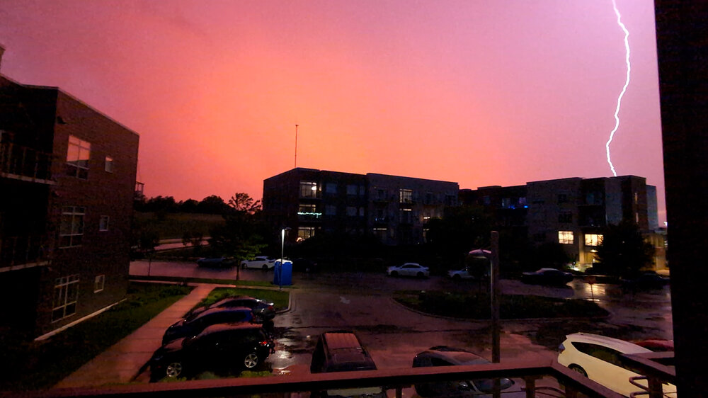
-
2024 Short/Medium Range Severe Weather Discussion
CheeselandSkies replied to Chicago Storm's topic in Lakes/Ohio Valley
00Z HRRR at least sort of depicted the severe-warned storms were getting here right now better than previous runs. It has consistently wanted to send tonight's eventual MCS much further north and east of most other CAMS, missing southern Wisconsin (and thus most of SPC's Enhanced area). -
2024 Short/Medium Range Severe Weather Discussion
CheeselandSkies replied to Chicago Storm's topic in Lakes/Ohio Valley
Not good. At least Radarscope on my phone is working for me. -
2024 Short/Medium Range Severe Weather Discussion
CheeselandSkies replied to Chicago Storm's topic in Lakes/Ohio Valley
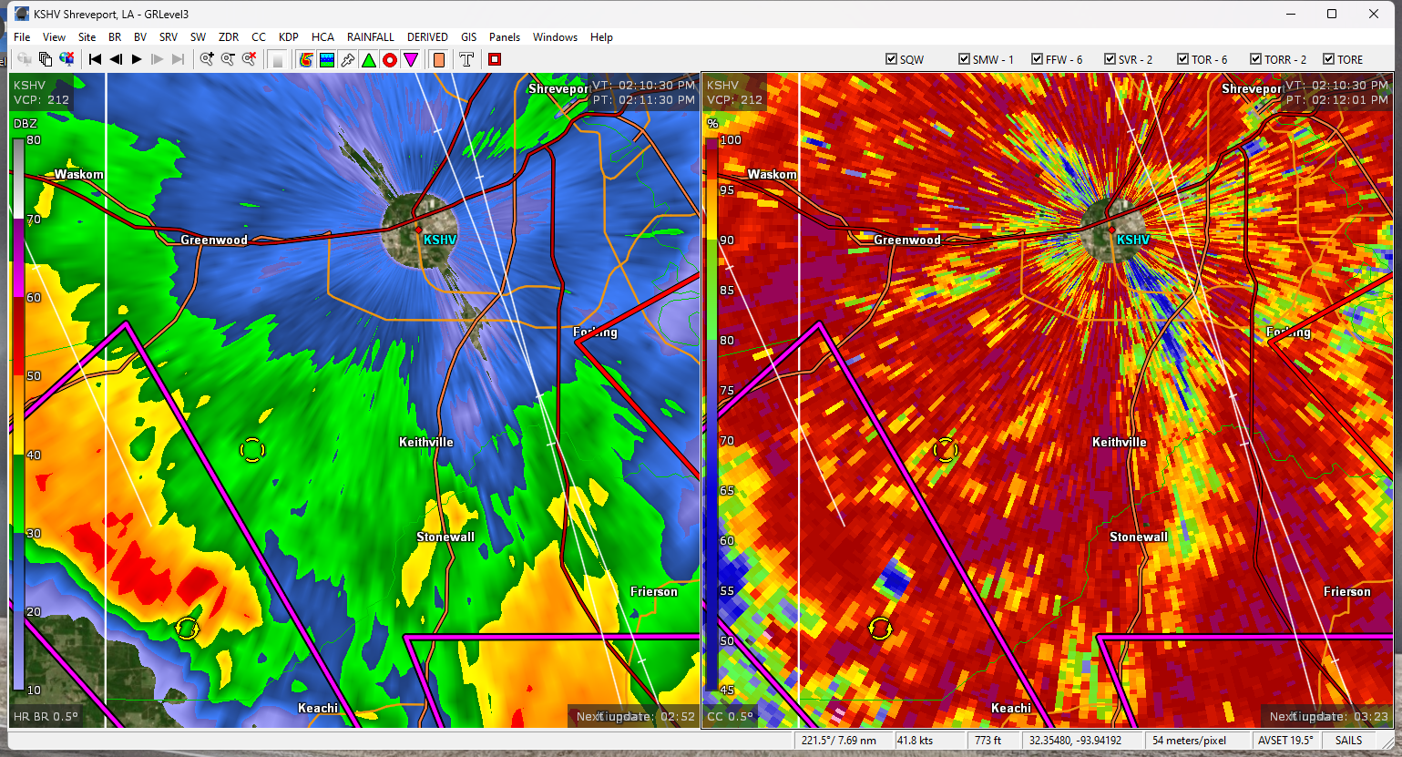
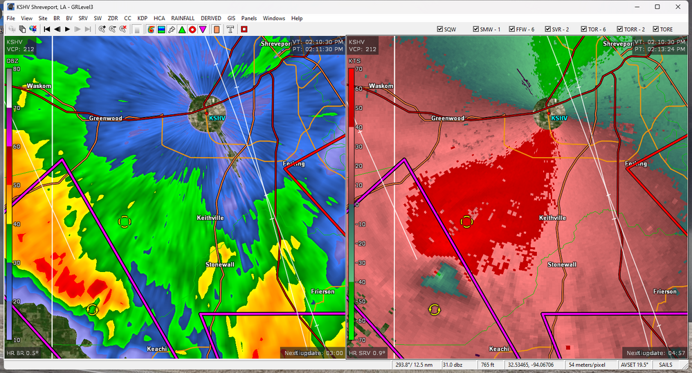
Few if any CAMs really had the activity ongoing over southern WI right now; certainly not the HRRR. Something is up with my GR Level 3 and it won't load any radar data. -
2024 Short/Medium Range Severe Weather Discussion
CheeselandSkies replied to Chicago Storm's topic in Lakes/Ohio Valley
For all the storms this year, been a while since we had an old-fashioned, southeastward-moving midnight classic Midwest 'Rachel. At least, one affecting southern Wisconsin. -
2024 Short/Medium Range Severe Weather Discussion
CheeselandSkies replied to Chicago Storm's topic in Lakes/Ohio Valley
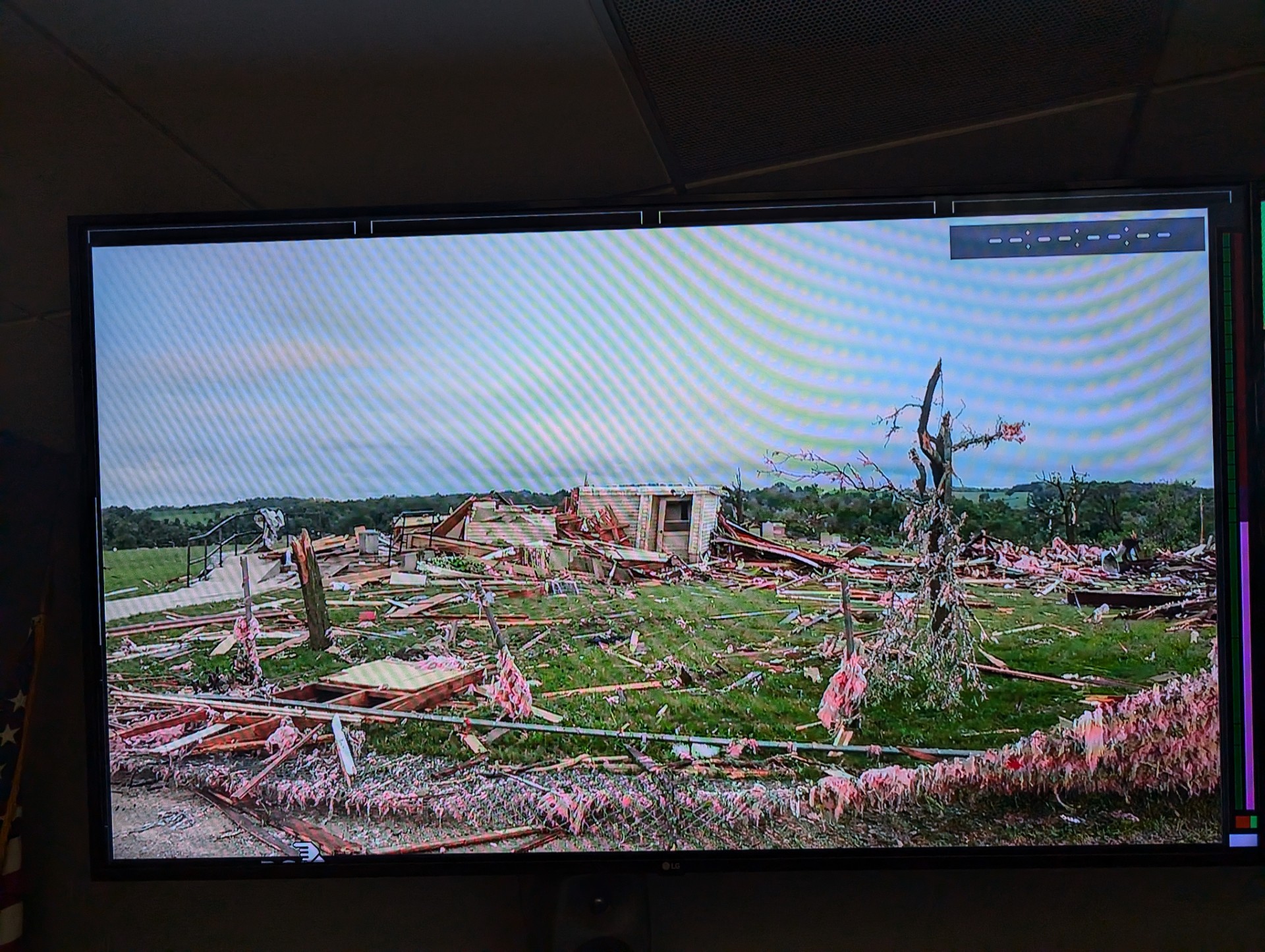
Argyle looks bad in the first look from our live camera at work this morning. This building was a historic church, and look at that tree damage. We don't see that in southern WI too often.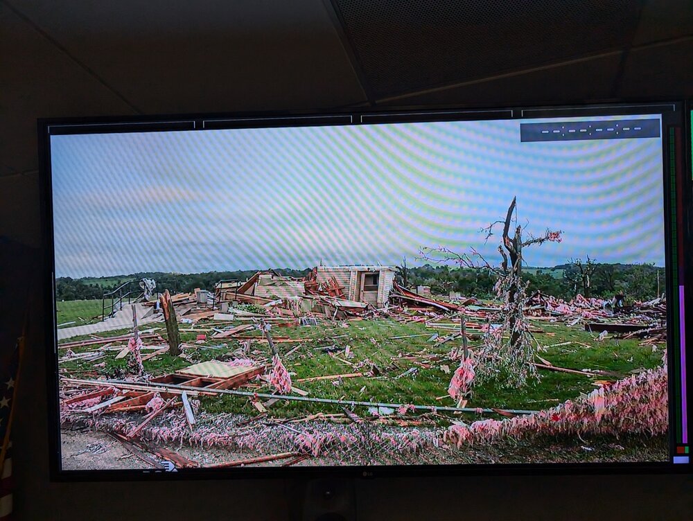
-
Late June 2024 MN/WI/IA Flooding Event
CheeselandSkies replied to Geoboy645's topic in Lakes/Ohio Valley
Seems like we missed the heavier totals where I am on the far SW side. Keeping an eye out for some action this afternoon. -
2024 Short/Medium Range Severe Weather Discussion
CheeselandSkies replied to Chicago Storm's topic in Lakes/Ohio Valley
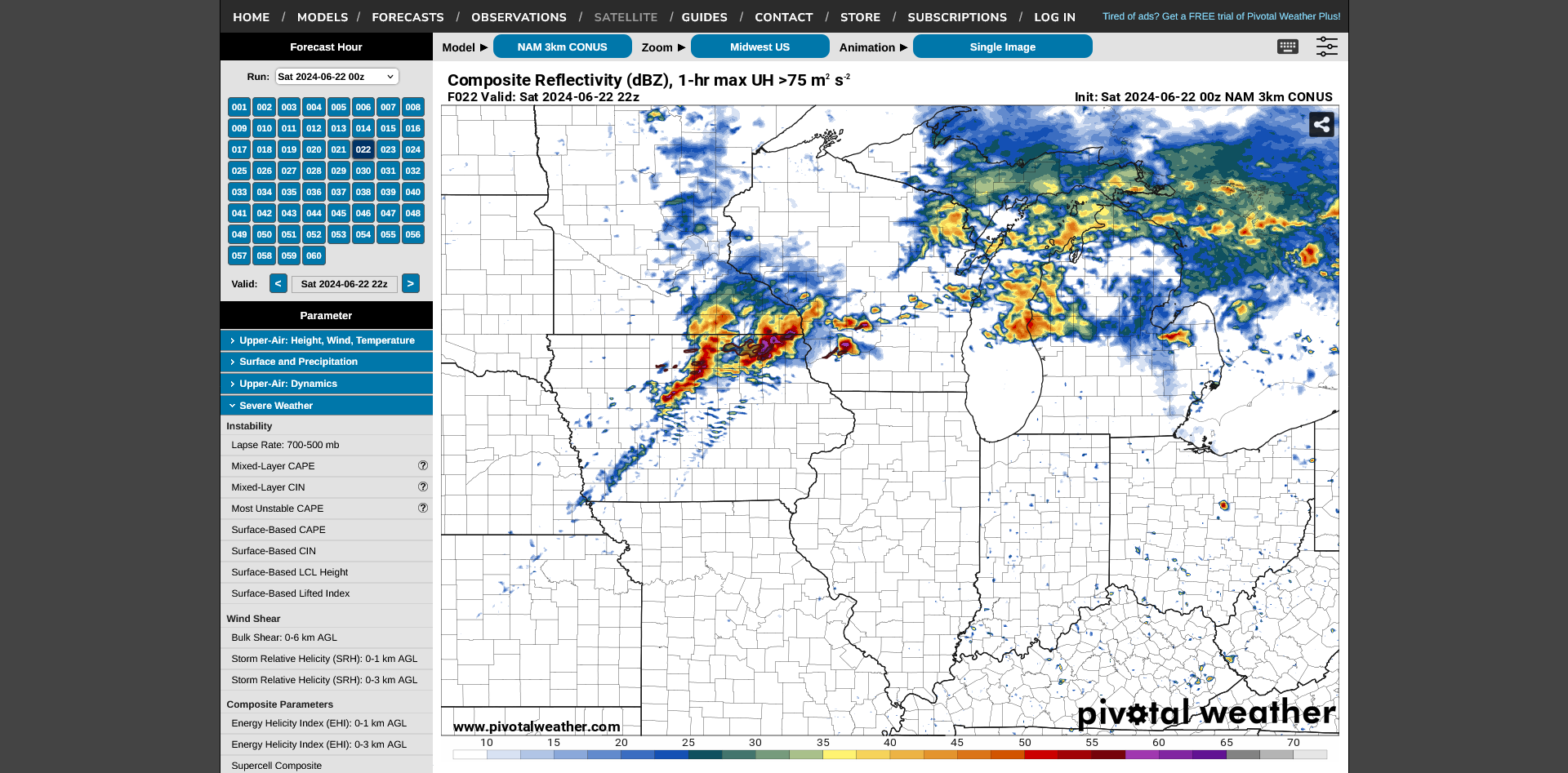
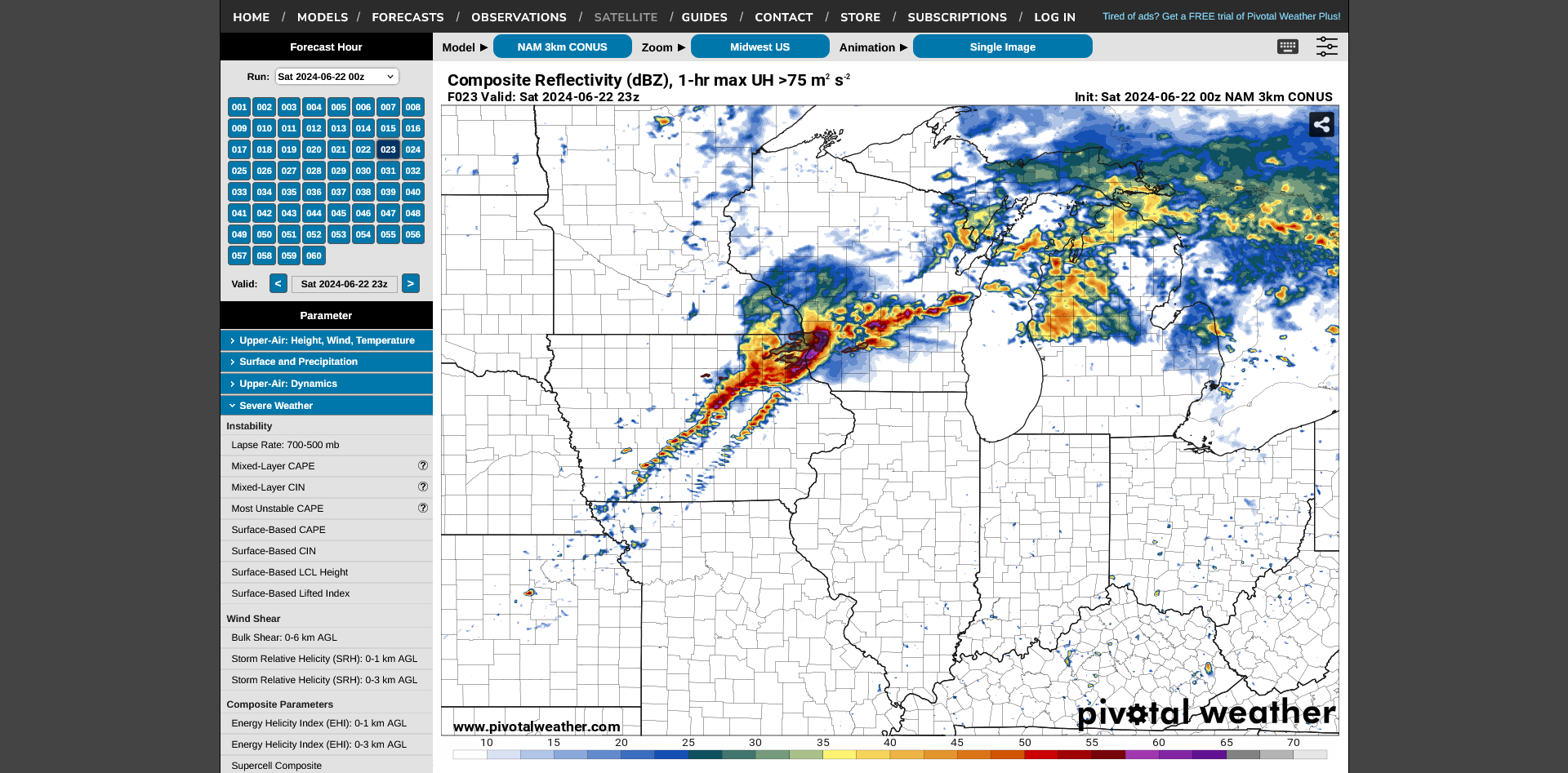
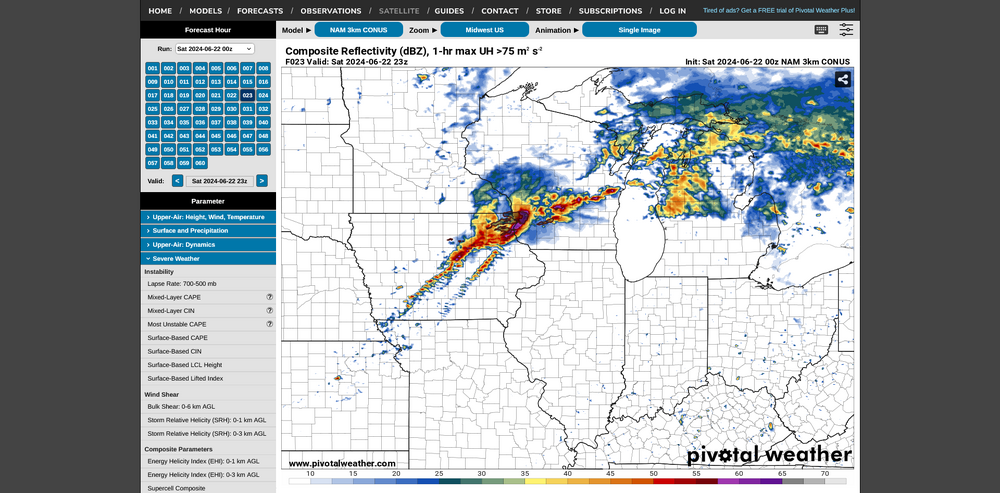
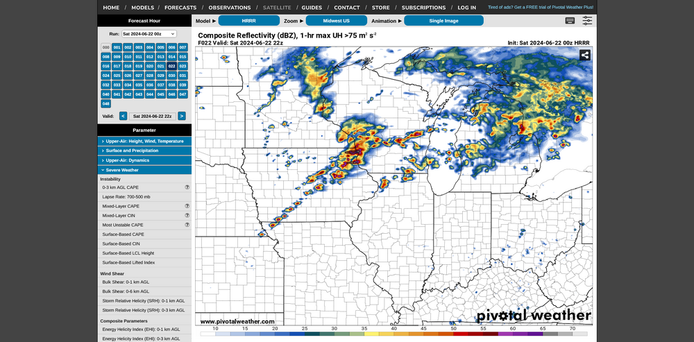
Multiple 0Z CAMs came in pretty hot for tomorrow across IA into S. WI. HRW-FV3 did as well, but it won't let me attach more. Still on the fence whether to try my luck with attempting to get a in Iowa again (after Keota last year, I've struck out three times there this year including April 26 and May 21), stay close to home and hope those discrete cells in WI on the 3KM verify, or stay *at* home and just watch the derecho roll in.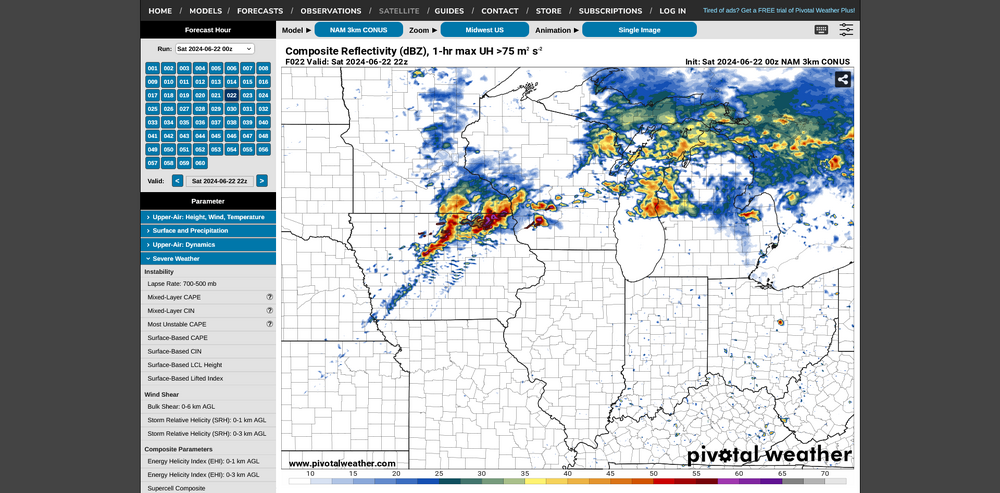
-
Late June 2024 MN/WI/IA Flooding Event
CheeselandSkies replied to Geoboy645's topic in Lakes/Ohio Valley
Edge of the polygon missed me by about a mile to the east. -
2024 Short/Medium Range Severe Weather Discussion
CheeselandSkies replied to Chicago Storm's topic in Lakes/Ohio Valley
Looks like watch in MN busted hard, strongest deep-layer shear remained behind the cold front with no sustained discrete development out ahead of it. -
2024 Short/Medium Range Severe Weather Discussion
CheeselandSkies replied to Chicago Storm's topic in Lakes/Ohio Valley
More recent runs of the GFS since my earlier post show a more robust low-level response; so could certainly get interesting on Thursday afternoon/evening. -
2024 Short/Medium Range Severe Weather Discussion
CheeselandSkies replied to Chicago Storm's topic in Lakes/Ohio Valley
SPC has Day 4/5 outlooks out for portions of the central-northern Plains to Midwest for Wednesday/Thursday. Global models show moisture returning north under a brisk northwest flow aloft; but not much in the way of a discernible surface response (deep SLP center, 850mb LLJ) for a focused threat. Will have to keep an eye on finer-scale mesoscale details for that, if it materializes. -
Tonight is the 40th anniversary of the Barneveld, WI F5 of 1984. Still by far the most significant tornado since 1950 for the south-central part of the state. Although we get our share of severe weather in southern Wisconsin, we average a Plains/Dixie Alley caliber cyclic, intense-violent tornadic supercell about once every 10-15 years. To have one occur in the middle of the night was even more extraordinary. With every regional severe weather event in my memory; storms that form as supercells in Iowa have invariably either grown upscale or weakened by the time they reach here late at night. https://www.wmtv15news.com/2024/06/07/barnaveld-torando-40-years-later/