CheeselandSkies
-
Posts
3,143 -
Joined
-
Last visited
Content Type
Profiles
Blogs
Forums
American Weather
Media Demo
Store
Gallery
Everything posted by CheeselandSkies
-
You said the "hurricane models" which I took to mean the frame-by-frame sim IR, MSLP, etc products from the HWRF, HAFS A/B, etc. Usually takes a couple hours after the run initialization time for those to even start showing up.
-
Eh? Those aren't even out yet on Tidbits.
-

2024 Atlantic Hurricane Season
CheeselandSkies replied to Stormchaserchuck1's topic in Tropical Headquarters
Stop copy/pasting what other people post on Storm2K. -
Are you "DunedinDave" on Storm2K or are you just copy/pasting others' posts from there? Sent from my Pixel 8 using Tapatalk
-
2024 Short/Medium Range Severe Weather Discussion
CheeselandSkies replied to Chicago Storm's topic in Lakes/Ohio Valley
A few pop-up severe storms in the region today, still hearing booms from the one that just rolled through southwest Madison. Almost looks like a legit supercell here in far SE MN approaching the MS River, although that outflow suggests production is unlikely.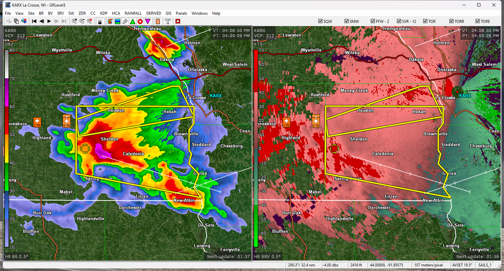
-
Being in a severe thunderstorm warning polygon was not on my bingo card for today.
-
2024 Atlantic Hurricane Season
CheeselandSkies replied to Stormchaserchuck1's topic in Tropical Headquarters

-
2024 Atlantic Hurricane Season
CheeselandSkies replied to Stormchaserchuck1's topic in Tropical Headquarters
Correct me if I'm wrong, but I think the 2013 comparison is apt because the alarm bells for this year were hit quite a bit harder than in 2013. 2013 was expected to be active, yes, but not "1933 in the satellite era" levels of insanity from ALL the seasonal forecasting sources of note. So the activity for 2024 has been somewhat greater, yes, but the bar was also set higher. Again, I could be wrong, since in the July-September period of 2013 I was moving and starting a new job, therefore I probably paid the least amount of attention to tropical weather of my life since I was old enough to watch John Hope on The Weather Channel. It was probably about midway through September when I was like "Huh, shouldn't there be some hurricane threats right about now? Guess it's a quiet season." -
2024 Atlantic Hurricane Season
CheeselandSkies replied to Stormchaserchuck1's topic in Tropical Headquarters
-
2024 Short/Medium Range Severe Weather Discussion
CheeselandSkies replied to Chicago Storm's topic in Lakes/Ohio Valley
My go-to CAMs (HRRR and 3K NAM, 12Z runs) both completely whiffed on the severe line which fired up in eastern WI late this morning and is now (in a considerably weakened state, even though there is a severe thunderstorm watch in effect out ahead of it) pushing into lower MI. Therefore, their depiction of activity (or lack thereof) for the rest of this afternoon/evening is rather suspect. -
2024 Short/Medium Range Severe Weather Discussion
CheeselandSkies replied to Chicago Storm's topic in Lakes/Ohio Valley
-
2024 Short/Medium Range Severe Weather Discussion
CheeselandSkies replied to Chicago Storm's topic in Lakes/Ohio Valley
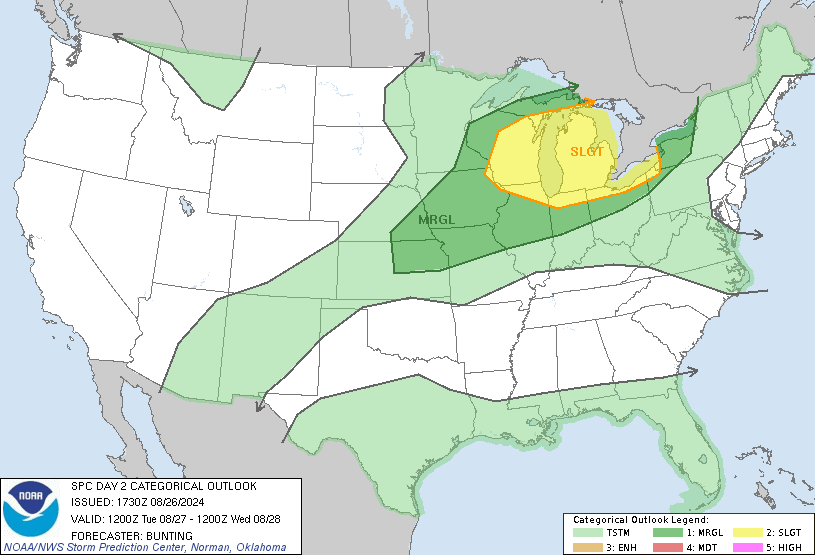
Next chance for the NW sub starts Monday evening, possibly continuing as far east as Michigan on Tuesday. -
2024 Atlantic Hurricane Season
CheeselandSkies replied to Stormchaserchuck1's topic in Tropical Headquarters
Atlantic tropics watchers in August 2024: Believe I posted this for August, 2022 as well. -
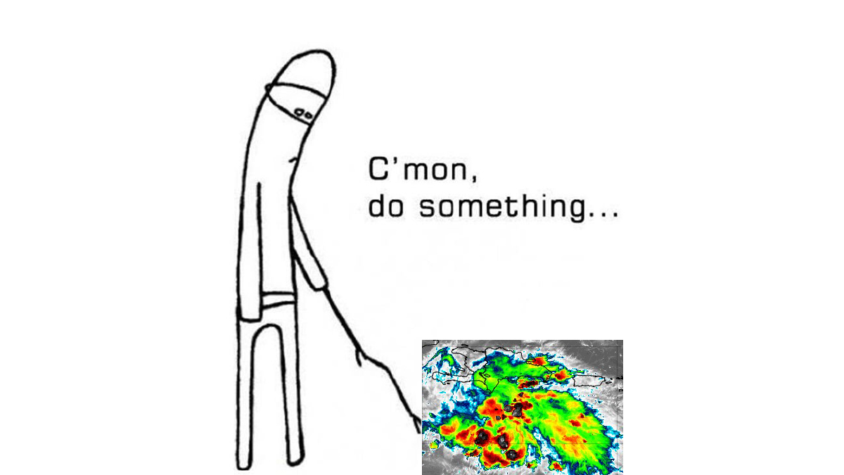
Somehow I doubt this mesoscale discussion for the TX/OK panhandles is related to Hurricane Ernesto...
-
2024 Short/Medium Range Severe Weather Discussion
CheeselandSkies replied to Chicago Storm's topic in Lakes/Ohio Valley
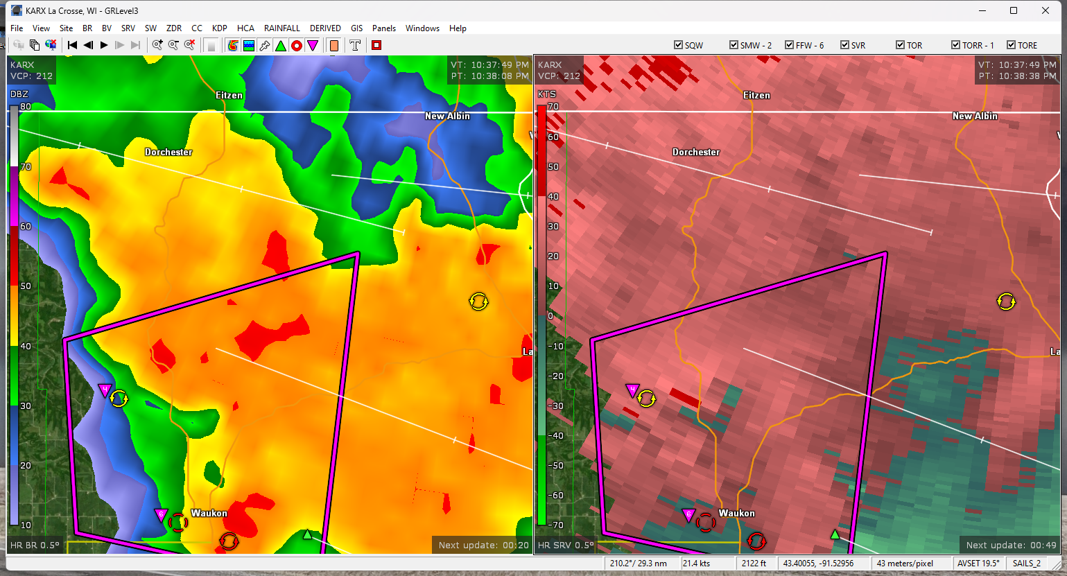
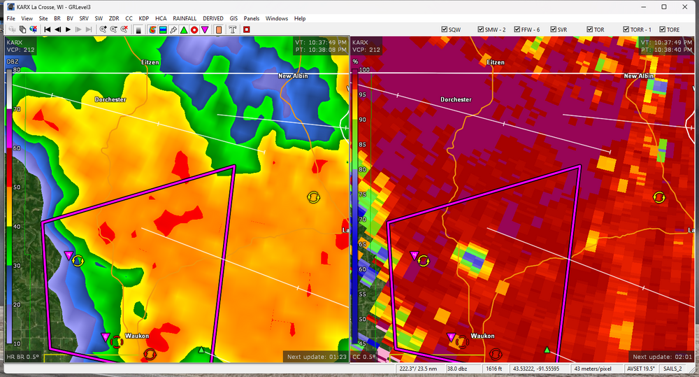
Decent-sized TDS near Waukon, IA persisted for several scans. At least one visible wedge occurred in south-central MN earlier. There was a "confirmed" tornado along the WI/IL state line around 0030 UTC but until I see otherwise I think it was a suspect public report. The storm collapsed shortly after. Maybe I'm just salty because I didn't pull the trigger on a chase in that area.
-
2024 Short/Medium Range Severe Weather Discussion
CheeselandSkies replied to Chicago Storm's topic in Lakes/Ohio Valley
15Z run has it back...this tells me this setup is right on the line of a warm sector cap bust and a potent tornadic supercell or two. Also quite a few more supercells behind that lead batch...they would likely not be entirely surface-based but could be capable of producing wind/hail and heavy rain. Worth nothing the HRRR is not completely on an island, the 12Z HRW WRF-ARW also fires a few supercells along the WI/IL state line in the 23-00Z timeframe. -
2024 Short/Medium Range Severe Weather Discussion
CheeselandSkies replied to Chicago Storm's topic in Lakes/Ohio Valley
Would need the warm front to lift north and on top of that something to break the cap in the warm sector. -
2024 Short/Medium Range Severe Weather Discussion
CheeselandSkies replied to Chicago Storm's topic in Lakes/Ohio Valley
Annnnd the 10/11/12Z runs backed off, go figure. -
2024 Short/Medium Range Severe Weather Discussion
CheeselandSkies replied to Chicago Storm's topic in Lakes/Ohio Valley
Overnight HRRR runs starting to get a little frisky with firing warm sector supercells in southwestern WI to far north-central IL. -
2024 Short/Medium Range Severe Weather Discussion
CheeselandSkies replied to Chicago Storm's topic in Lakes/Ohio Valley
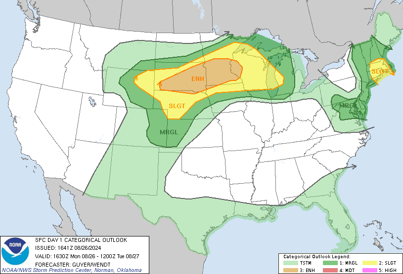
Models have been painting a beautiful environment along a NW-SE oriented warm front from roughly south-central MN to SW WI tomorrow evening. However, most of them keep the warm sector capped. SPC has introduced a slight risk/5% just in case... -
2024 Short/Medium Range Severe Weather Discussion
CheeselandSkies replied to Chicago Storm's topic in Lakes/Ohio Valley
Consensus has trended toward a miss south/west for southern Wisconsin as far as the bulk of the severe weather over the next few days, but SPC has kept us in a marginal risk due to uncertainty. -
2024 Atlantic Hurricane Season
CheeselandSkies replied to Stormchaserchuck1's topic in Tropical Headquarters
The nhc discounted it and went mandarin. They know better than to forecast based on run-to-run op model flip-flopping. -
2024 Short/Medium Range Severe Weather Discussion
CheeselandSkies replied to Chicago Storm's topic in Lakes/Ohio Valley
Tail end of the range of course but NAM went bonkers with the EHI/SCP over northern Illinois on Monday. CAPE so fat it's gonna need to call Dr. Nowzaradan.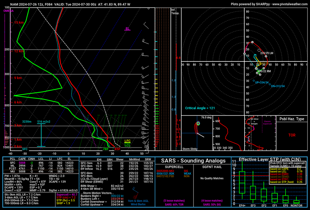
-
2024 Short/Medium Range Severe Weather Discussion
CheeselandSkies replied to Chicago Storm's topic in Lakes/Ohio Valley
12Z runs came in a bit hot for Monday-Wednesday after waffling some starting shortly after I made my previous post (go figure). We shall see. -
2024 Atlantic Hurricane Season
CheeselandSkies replied to Stormchaserchuck1's topic in Tropical Headquarters
@ldub23 is a known tropical troll and king weinerhead. He downcasted 2017 hard like three days before Harvey spun back up and did what it did to Texas.