

SRRTA22
-
Posts
1,828 -
Joined
-
Last visited
Content Type
Profiles
Blogs
Forums
American Weather
Media Demo
Store
Gallery
Everything posted by SRRTA22
-

August 2019 General Discussions & Observations Thread
SRRTA22 replied to bluewave's topic in New York City Metro
So happy many of you guys got to experience what I experienced! -
August 2019 General Discussions & Observations Thread
SRRTA22 replied to bluewave's topic in New York City Metro
Didn't mean for my comment to come off like that, just letting you know. Strong straight line winds and heavy rain can create some surreal moments! -
August 2019 General Discussions & Observations Thread
SRRTA22 replied to bluewave's topic in New York City Metro
Straight line winds. -
August 2019 General Discussions & Observations Thread
SRRTA22 replied to bluewave's topic in New York City Metro
Winds were pushing my friend's car while he was driving. Thankfully the winds were quick and lasted only a couple of minutes. So probably gonna see isolated damage...nonetheless most impressive storm I've seen in years in terms of wind.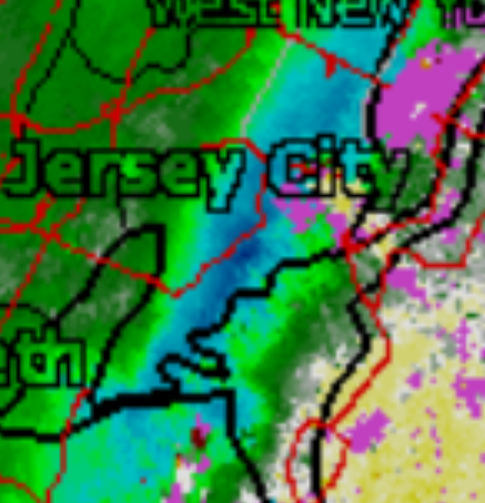
-
August 2019 General Discussions & Observations Thread
SRRTA22 replied to bluewave's topic in New York City Metro
Defitnitly above 55mph...that was insane -
August 2019 General Discussions & Observations Thread
SRRTA22 replied to bluewave's topic in New York City Metro
Holy.....craziest storm of the summer by far!!! -
August 2019 General Discussions & Observations Thread
SRRTA22 replied to bluewave's topic in New York City Metro
Incoming... Severe Thunderstorm Warning NJC013-017-039-NYC047-085-230045- /O.NEW.KOKX.SV.W.0075.190822T2354Z-190823T0045Z/ BULLETIN - IMMEDIATE BROADCAST REQUESTED Severe Thunderstorm Warning National Weather Service New York NY 754 PM EDT Thu Aug 22 2019 The National Weather Service in Upton NY has issued a * Severe Thunderstorm Warning for... Hudson County in northeastern New Jersey... Union County in northeastern New Jersey... Southern Essex County in northeastern New Jersey... Richmond County in southeastern New York... Kings County in southeastern New York... * Until 845 PM EDT. * At 753 PM EDT, a severe thunderstorm was located over Morristown, moving southeast at 35 mph. HAZARD...60 mph wind gusts. SOURCE...Radar indicated. IMPACT...Expect damage to trees and power lines. * This severe thunderstorm will be near... Plainfield and Summit around 805 PM EDT. Orange around 810 PM EDT. Clark and Union around 815 PM EDT. Newark and Elizabeth around 820 PM EDT. Port Richmond around 825 PM EDT. Jersey City and Bayonne around 830 PM EDT. The Verrazano Narrows Bridge and Bay Ridge around 835 PM EDT. Flatbush and Coney Island around 840 PM EDT. Sheepshead Bay around 845 PM EDT. -
August 2019 General Discussions & Observations Thread
SRRTA22 replied to bluewave's topic in New York City Metro
18z 3k NAM brings in a heavy complex of storms into the area later tonight(also showing modest SBCAPE/MUCAPE around ~1500j/kg with decent shear values). Im thinking it might be right as current radar shows a developing complex in NE PA, with a warned storm just N of Allentown. See what happens later! -
August 2019 General Discussions & Observations Thread
SRRTA22 replied to bluewave's topic in New York City Metro
Low cape, high shear....maybe some isolated overnight weak spinners? -
August 2019 General Discussions & Observations Thread
SRRTA22 replied to bluewave's topic in New York City Metro
Below severe criteria winds but man was the wind intense. I'd say 45-50mph , leaves blowing all over the place. Sheet rain. Crazy -
August 2019 General Discussions & Observations Thread
SRRTA22 replied to bluewave's topic in New York City Metro
I forgot what year it was but it was defitnitly early 2000s, in April. There was a heavy Tstorm squall with temps in the 50s and the temp instantly plummeted and the rain changed to heavy snow. One of the most surreal wx moments I've witnessed -
August 2019 General Discussions & Observations Thread
SRRTA22 replied to bluewave's topic in New York City Metro
I want us to hit 80f in Feb again -
August 2019 General Discussions & Observations Thread
SRRTA22 replied to bluewave's topic in New York City Metro
Man....I was walking outside and a bolt struck no more then 4 blocks in front of me. Talk about needing a change of pants -
August 2019 General Discussions & Observations Thread
SRRTA22 replied to bluewave's topic in New York City Metro
I don't think they'll make it but you never know. Hrrr says no, 18z 3k NAM thinks so. -
August 2019 General Discussions & Observations Thread
SRRTA22 replied to bluewave's topic in New York City Metro
1.30 for the day. -
August 2019 General Discussions & Observations Thread
SRRTA22 replied to bluewave's topic in New York City Metro
Very dark to my west -
August 2019 General Discussions & Observations Thread
SRRTA22 replied to bluewave's topic in New York City Metro
Very nice capture! -
August 2019 General Discussions & Observations Thread
SRRTA22 replied to bluewave's topic in New York City Metro
Sick rainbow to my east to end the day -
August 2019 General Discussions & Observations Thread
SRRTA22 replied to bluewave's topic in New York City Metro
@doncat looks like you'll get to cash in on that storm just south of Morristown -
August 2019 General Discussions & Observations Thread
SRRTA22 replied to bluewave's topic in New York City Metro
Another Tstorm incoming I frickin' love this summer -
August 2019 General Discussions & Observations Thread
SRRTA22 replied to bluewave's topic in New York City Metro
Nice shot and really? Winds were quite strong here. 40-45 -
August 2019 General Discussions & Observations Thread
SRRTA22 replied to bluewave's topic in New York City Metro
Severe Tstorms Warning in effect for Hudson co -
August 2019 General Discussions & Observations Thread
SRRTA22 replied to bluewave's topic in New York City Metro
I'm in south Jersey City , and those storms look very intense . Somewhat of a wall loud looking feature to my west. Probably scud but looks very ominous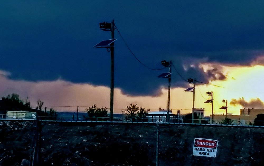
-
August 2019 General Discussions & Observations Thread
SRRTA22 replied to bluewave's topic in New York City Metro
I'll trade the next few winter's for summers just like this please. -
August 2019 General Discussions & Observations Thread
SRRTA22 replied to bluewave's topic in New York City Metro
Be careful guys, even though the main line has moved through, theres some very intense CTG behind it.


