
SRRTA22
-
Posts
1,828 -
Joined
-
Last visited
Content Type
Profiles
Blogs
Forums
American Weather
Media Demo
Store
Gallery
Everything posted by SRRTA22
-
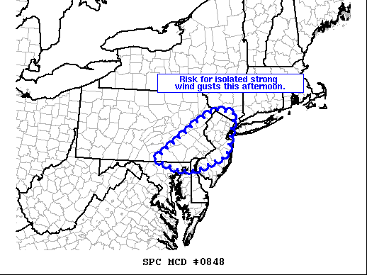
That line has embedded rotations and a new warning has been issued for NE NJ which has a TOR possible attached to it SPC has also issued a severe thunderstorm watch for NYC metro The NWS Storm Prediction Center has issued a * Severe Thunderstorm Watch for portions of Connecticut Delaware New Jersey Southern New York Far Eastern Pennsylvania Coastal Waters * Effective this Friday afternoon and evening from 305 PM until 800 PM EDT. * Primary threats include... Scattered damaging wind gusts to 65 mph possible Isolated large hail events to 1 inch in diameter possible SUMMARY...Clusters of storms will move east-southeastward toward New Jersey and southern New York including the New York City vicinity, with the strongest storms capable of wind damage and marginally severe hail.
-
SUMMARY...A few stronger storms will continue shifting eastward across the Delaware Valley and southeastern Pennsylvania into New Jerse and the New York City area this afternoon. Locally strong/gusty winds are expected. A WW may be considered. DISCUSSION...Latest radar Loop shows a area of thunderstorms moving slowly eastward across eastern Pennsylvania and into northwestern New Jersey at this time. A few stronger storms have evolved -- aided by 1000 to 1500 J/kg mixed-layer CAPE as boundary-layer heating occurs beneath cool air aloft/steep lapse rates in conjunction with the vort max/short-wave trough crossing the central Appalachians. While lower tropospheric flow remains rather weak, moderate westerly mid-level flow is sufficient to support multicell-type organization, and thus potential for gusty winds capable of minor damage -- primarily limited to tree damage. As storms continue shifting eastward, they will begin affecting western fringes of the New York City metro area in the next 1 to 2 hours.
-
Looks like NYC gets their storms today. Considerably more surface CAPE compared to yesterday at around 1500-2000 j/kg hudson river west and around 500-1000 j/kg east of the hudson. Less shear but still enough for some iso damg gusts. Nice complex of storms to our west should maintain its way through long island.
-
Yesterday couldve been a big deal in the metro. That was a pretty intense complex of storms.
-
SPC issued a marginal risk for NYC Looks meh but we usually get good storms in marginal set ups haha
-
Bringing this to banter. A substantial size asteroid hit Russia back in like 2013... The fact of the matter is...theres ALOT of rocks, that can hit us undetected...Jupiter has been our saving grace for so long its not even funny
-
It's already crashed. Right into the Indian Ocean. People reported seeing it low in altitude over the middle-east. Trending on twitter now
-
 It was either over or across the newark bay and moving fast to the southeast which would be left in the picture. These cells were weird...they looked like passing showers on radar, but looked really convective in person with some nice structures
 -
I just saw the same thing at 7:20 PM we had a storm move in which produced very small hail. I noticed a very noticeable lowering towards the west around the newark bay. Thats when i got a better view and saw a cone shaped cloud. I took a photo but is really low quality so my apologies in advance. Couldn't tell if it was rotating as Im blind as a bat. It's probably nothing but then again, it really did have that look...Don't think we'll ever know

-
You are a gem for our subforum rclab...never change. "as always"
-
Got covid now. Body chills, sweating, sinus pressure and mild headache with a slight cough. Also extreme fatigue The first symptom i noticed was the sinus pressure. The fatigue is crazy.
-
SQLN severe risk 6P-10P, then wind advisory CAA G40KT early Monday
SRRTA22 replied to wdrag's topic in New York City Metro
Gust to 47mph with the squall Max wind adv gust of 51mph Jersey City,NJ -
Jumped 20 degrees in 3 hours, 58f at 10:30 now 78 at 1:30 Jersey City,NJ
-
Chilly with a cold NE wind here in Jersey City 55f and cloudy
-
I dont know if its just me but it feels more humid then it is. DP only 48 but to me it felt more like the upper 50s
-
Absolutely. Heck of a year all around really.. multiple tropical threats, good tstorms and a good winter to top it off. Not too shabby imo
-
OBS and nowcast Thursday morning 2/18 - 11PM Friday 2/19/21
SRRTA22 replied to wdrag's topic in New York City Metro
3.0" on the dot here for round 1 in Jersey City,NJ - measured multiple times at noon before the changeover to sleet -
We're going to get a 40" blizzard one day and you're all gonna hate it Lol
-
January 2021 General Discussions & Observations Thread
SRRTA22 replied to Stormlover74's topic in New York City Metro
Just had some loud thunder here with this incoming low topped squall -
Also saw some transformers exploding. Impressive wind out there
- 242 replies
-
- 1
-

-
- damaging wind
- flooding rains
- (and 1 more)
-
Mix in jersey city
-
Forky loves snow
-
Not sure if you remember...meatball parm counters it...
-
For some reason, this brings me early 2000s forum vibes...will there be a radio show this weekend?
-
December 2020 General Discussions & Observations Thread
SRRTA22 replied to bluewave's topic in New York City Metro
Snow started around 11-11:30AM here in Jersey City, coming down decently here and there. Nice dusting on grassy areas