SRRTA22
-
Posts
1,828 -
Joined
-
Last visited
Content Type
Profiles
Blogs
Forums
American Weather
Media Demo
Store
Gallery
Everything posted by SRRTA22
-

Sun July 11-Mon July 19 Pockets of FF/SVR and a modest heat wave
SRRTA22 replied to wdrag's topic in New York City Metro
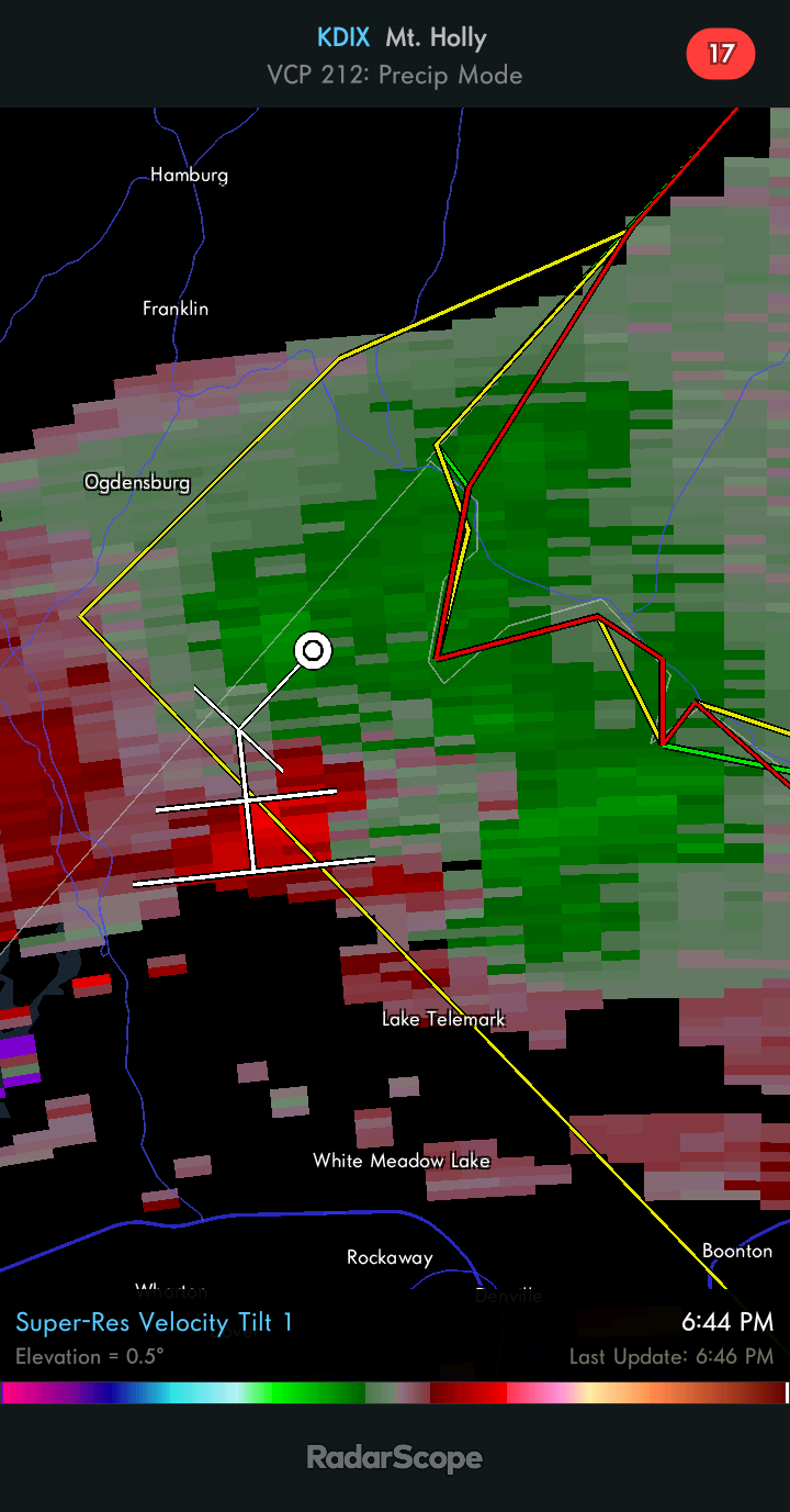
The rotation looks to have redeveloped outside the warning area, just north of Lake Telemark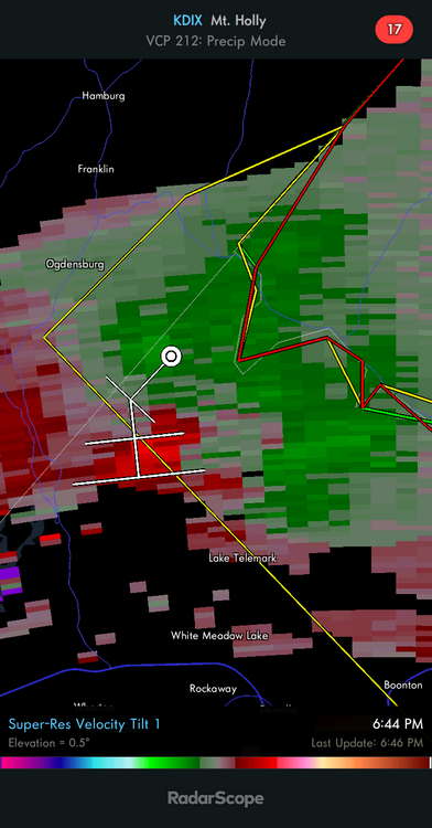
- 382 replies
-
- 1
-

-
- flash flooding
- severewx
- (and 1 more)
-
Sun July 11-Mon July 19 Pockets of FF/SVR and a modest heat wave
SRRTA22 replied to wdrag's topic in New York City Metro
Storm went bow and created another meso vortex over an isolated part of the area. Non svr and quickly weakened but man did it try..at 2am. Impressive Ultimate summer weenie band...lol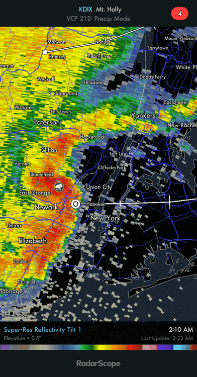
-
Sun July 11-Mon July 19 Pockets of FF/SVR and a modest heat wave
SRRTA22 replied to wdrag's topic in New York City Metro
Its just one of those summers. Thing maintained all the way from central pa -
Went from a maritime like airmass with llvl drizzle and easterly winds to a complete sauna. Can feel the moisture in the air
-
Thats a nice MCS in PA
-
Coming from the man who lives in the tornado capitol of the nyc metro That thing tried really hard to wrap around its outflow boundary over S.I/Bayonne - awesome to see. I said the same thing.. "how is it not warned" until I saw it was packing maybe 25-35mph winds haha. Lightning was awesome
-
The storm tried really hard to go supercell but I didnt see anything that warranted a warning. It was close though
-
Looks the the whole area(nyc metro) is about to blossom with storms. Its certainly juicy out there
-
SVR-PRE (ELSA) potential NYC subforum Tue-Fri morning July 6-9, 2021
SRRTA22 replied to wdrag's topic in New York City Metro
I see an Mping report from Long Island , near Farmingville of power poles broken -
SVR-PRE (ELSA) potential NYC subforum Tue-Fri morning July 6-9, 2021
SRRTA22 replied to wdrag's topic in New York City Metro
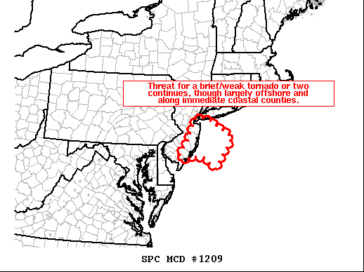
What looks like a large waterspout is about to move onshore near Mantoloking,NJ or just south of Point Pleasant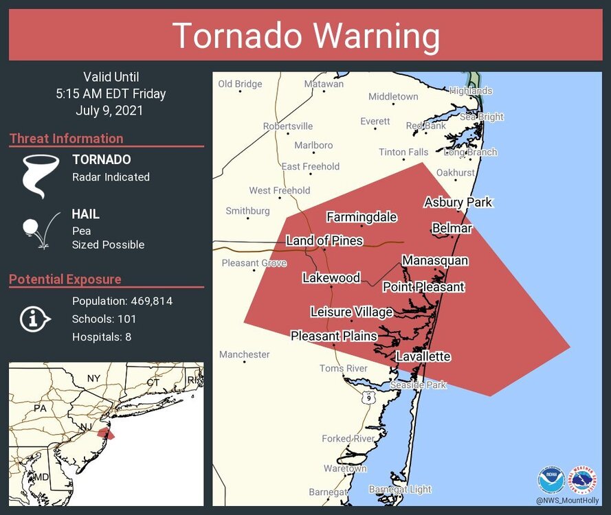
-
SVR-PRE (ELSA) potential NYC subforum Tue-Fri morning July 6-9, 2021
SRRTA22 replied to wdrag's topic in New York City Metro
-
SVR-PRE (ELSA) potential NYC subforum Tue-Fri morning July 6-9, 2021
SRRTA22 replied to wdrag's topic in New York City Metro
I like NYC east for some possible TOR action between 5-9am -
SVR-PRE (ELSA) potential NYC subforum Tue-Fri morning July 6-9, 2021
SRRTA22 replied to wdrag's topic in New York City Metro
Agreed. HRRR wants nothing to do with us. Develops the convection in PA and moves it NW into upstate NY and the hudson river valley. Its done a great job today thus far. Im intrigued by tomorrow actually. Soundings on the NAM are pretty wild for our area. -
SVR-PRE (ELSA) potential NYC subforum Tue-Fri morning July 6-9, 2021
SRRTA22 replied to wdrag's topic in New York City Metro
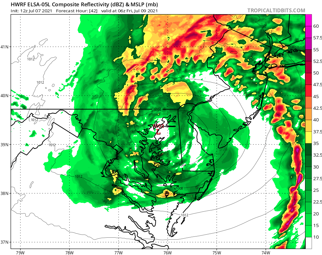
Im wondering if the HWRF is out to lunch with how far west Elsa gets. It scoots offshore in NJ but it would get far enough west where tornados and supercells would be a threat. Have to monitor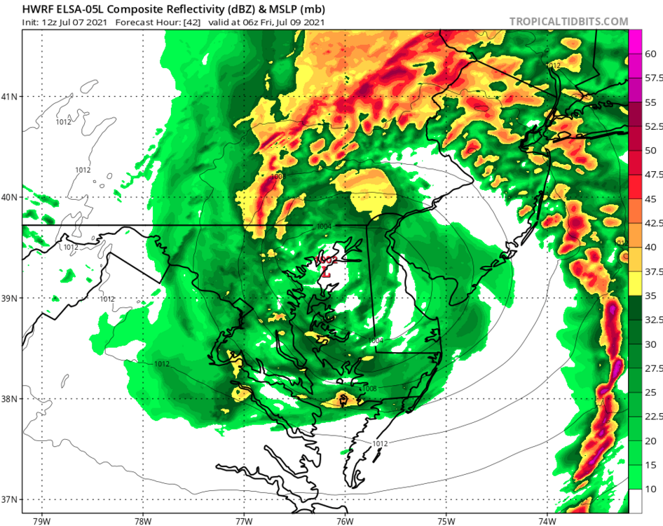
-
SVR-PRE (ELSA) potential NYC subforum Tue-Fri morning July 6-9, 2021
SRRTA22 replied to wdrag's topic in New York City Metro
Union county always gets the goods. Hudson county is usually the graveyard for svr wx. Most of us always do well with storms coming from the NW. Storms moving from the south usually produce for us as well -
SVR-PRE (ELSA) potential NYC subforum Tue-Fri morning July 6-9, 2021
SRRTA22 replied to wdrag's topic in New York City Metro
I live in that area. I haven't seen hail today nor tonight. Though alot of wind damage -
SVR-PRE (ELSA) potential NYC subforum Tue-Fri morning July 6-9, 2021
SRRTA22 replied to wdrag's topic in New York City Metro
Those storms have frequent lightning with it I can see them from here -
SVR-PRE (ELSA) potential NYC subforum Tue-Fri morning July 6-9, 2021
SRRTA22 replied to wdrag's topic in New York City Metro
For those into photography, now would be the time to get those ultra cool sky crawling lightning shots! These complexes ALWAYS have great photogenic lightning on the backside in the stratiform rain -
SVR-PRE (ELSA) potential NYC subforum Tue-Fri morning July 6-9, 2021
SRRTA22 replied to wdrag's topic in New York City Metro
Im not sure how long its been since a thunderstorm caused this much wind damage. The flooding rains on friday def played a big role -
SVR-PRE (ELSA) potential NYC subforum Tue-Fri morning July 6-9, 2021
SRRTA22 replied to wdrag's topic in New York City Metro
Fire department is stretched thin, widespread tree and powerline damage. Worst wind damage since Isaias -
SVR-PRE (ELSA) potential NYC subforum Tue-Fri morning July 6-9, 2021
SRRTA22 replied to wdrag's topic in New York City Metro
Sorry that you missed out but this was much more than garden variety here. Despite the lack of rain -
SVR-PRE (ELSA) potential NYC subforum Tue-Fri morning July 6-9, 2021
SRRTA22 replied to wdrag's topic in New York City Metro
Theres multiple trees down in several areas in Jersey City, some leaning on powerlines. Some lines down. I submitted the report to the NWS. -
SVR-PRE (ELSA) potential NYC subforum Tue-Fri morning July 6-9, 2021
SRRTA22 replied to wdrag's topic in New York City Metro
Reports of trees and wires down in Jersey City via Police scanner Highest gust in Jersey city via PWS 56mph -
SVR-PRE (ELSA) potential NYC subforum Tue-Fri morning July 6-9, 2021
SRRTA22 replied to wdrag's topic in New York City Metro
Very intense winds -
SVR-PRE (ELSA) potential NYC subforum Tue-Fri morning July 6-9, 2021
SRRTA22 replied to wdrag's topic in New York City Metro
Mping report of roof blown off near Wayne, not sure if its legit or not