Silver Meteor
-
Posts
238 -
Joined
-
Last visited
Content Type
Profiles
Blogs
Forums
American Weather
Media Demo
Store
Gallery
Everything posted by Silver Meteor
-
Southern Crippler - Get well soon Jimbo Storm Obs
Silver Meteor replied to BooneWX's topic in Southeastern States
I got lucky, the ice here in Greenville, NC melted overnight and I managed to complete my cataract surgery this morning. Still woozy and blurry but hoping vision improves in a few hours. Best wishes your surgery goes well. -
January 24-26: Miracle or Mirage OBS Thread!
Silver Meteor replied to Jebman's topic in Mid Atlantic
Reminds me of Stephen King's great book and TV miniseries "The Langoliers." They're coming to get you! -
January 24-26: Miracle or Mirage OBS Thread!
Silver Meteor replied to Jebman's topic in Mid Atlantic
20008 eh, mine was 20016 before they changed the system. It then became 20816. For the first 12 years of my life my address was "Washington, 16 D.C." despite living on the Maryland side of Mass. Ave. That was because Friendship Heights was the nearest post office. Zip Codes were created in 1963. -
January 24-26: Miracle or Mirage OBS Thread!
Silver Meteor replied to Jebman's topic in Mid Atlantic
Is there a movie theater and fire station near there? It looks a familiar area. -
2025-2026 Fall/Winter Mountain Thread
Silver Meteor replied to Buckethead's topic in Southeastern States
That's very different than what we've been expecting in Eastern N.C. For example it shows 0.45 ZR in Greenville when we've been expecting only 0.10 since yesterday. This would be awful! -
January 24-26: Miracle or Mirage OBS Thread!
Silver Meteor replied to Jebman's topic in Mid Atlantic
THE WEDGE A bit out of your range (off to your southwest) but interesting anyway, at 3K feet elevation in northwest NC (near Boone) it's 17.8/15.8 with mix of sleet/ZR. -
Spotted it Tuesday night and posted in Southeast Forum:

-
Thank you for showing a Mid-Atlantic view.
-
January 24-26: Miracle or Mirage JV/Banter Thread!
Silver Meteor replied to SnowenOutThere's topic in Mid Atlantic
Well said. When I worked at Naval Research and Development (DTNSRDC) in Carderock, Md. we had heavy duty computer power (4 Control Data Corp. mainframes plus one from Burroughs Corp.) The "software people" were the systems analysts who maintained the computers while the actual users (the "programmers,") were scientists and engineers who used FORTRAN's powerful mathematics simply as a tool of their trade. -
Helps to put your location in your profile. I've no idea where "me" is.
-
January 24-26: Miracle or Mirage JV/Banter Thread!
Silver Meteor replied to SnowenOutThere's topic in Mid Atlantic
DOS you say? Gracious I haven't heard that mentioned in eons. I learned computer programming (COBOL, FORTRAN, RPG and ASSEMBLY) on an IBM 360 with DOS operating system back in the late 1970s. Well, at least I'd guess you weren't using punch cards and vacuum tape drives in 2009, right? -
January 25/26 Jimbo Back Surgery Storm
Silver Meteor replied to Jimbo!'s topic in Southeastern States
Where does this physically reside in the atmosphere? How many thousands of feet up, or what general millibar area? -
January 25/26 Jimbo Back Surgery Storm
Silver Meteor replied to Jimbo!'s topic in Southeastern States
Don't even get me started on "plausible." Sigh. -
January 25/26 Jimbo Back Surgery Storm
Silver Meteor replied to Jimbo!'s topic in Southeastern States
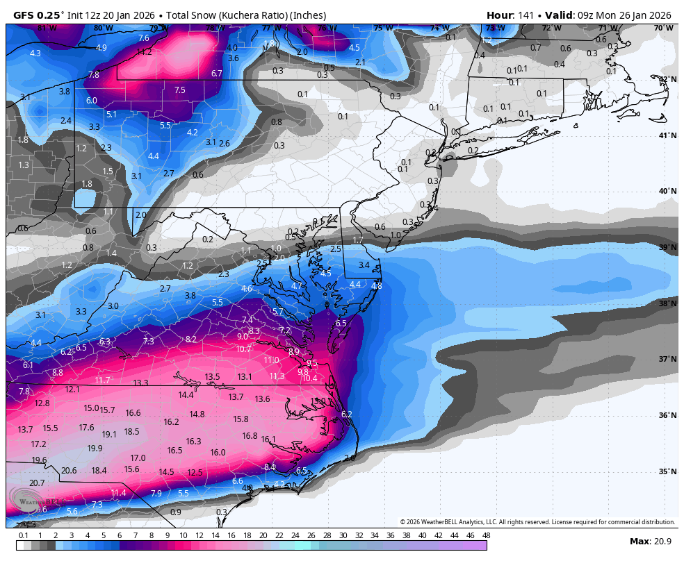
I posted this GFS storm a couple days ago. We're getting three? LOL
-
January 25/26 Jimbo Back Surgery Storm
Silver Meteor replied to Jimbo!'s topic in Southeastern States
0.51" freezing rain for Greenville, NC ??? PASS THE VAPORS! I thought we'd be saved by our proximity to the coast. -
January 25/26 Jimbo Back Surgery Storm
Silver Meteor replied to Jimbo!'s topic in Southeastern States
Thanks for the insight. -
Oh you Yankees, LOL. That Low is forming at Cape Lookout (Morehead City.) Wilmington is the next one down, Cape Fear.
-
January 25/26 Jimbo Back Surgery Storm
Silver Meteor replied to Jimbo!'s topic in Southeastern States
GFS and EURO with new data. Thank you! -
January 25/26 Jimbo Back Surgery Storm
Silver Meteor replied to Jimbo!'s topic in Southeastern States
It would make the ice storm WORSE. I want this whole mess to move north and get the heck out of here. If it comes back south the ice QPF would increase! -
January 25/26 Jimbo Back Surgery Storm
Silver Meteor replied to Jimbo!'s topic in Southeastern States
Right, right ... the GFS has done such a great job. Let me remind you of yesterday's 12Z run:
-
January 25/26 Jimbo Back Surgery Storm
Silver Meteor replied to Jimbo!'s topic in Southeastern States
From what I've read the recon data shows up on tonight's 00Z runs. As for the euro I've no idea. -
January 25/26 Jimbo Back Surgery Storm
Silver Meteor replied to Jimbo!'s topic in Southeastern States
Look at the isobars on that sumbitch! -
January 25/26 Jimbo Back Surgery Storm
Silver Meteor replied to Jimbo!'s topic in Southeastern States
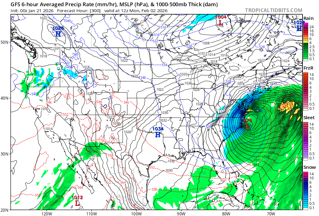
Hey folks, there's always the Feb 2 storm. What could go wrong?
-
January 25/26 Jimbo Back Surgery Storm
Silver Meteor replied to Jimbo!'s topic in Southeastern States
Small changes upstream may lead to bigger changes downstream. If they accrue over time one ends up with huge fails. Such is the world we live in. Seeing my Eastern N.C. digital snow go up in flames is so routine it's sickening. -
January 25/26 Jimbo Back Surgery Storm
Silver Meteor replied to Jimbo!'s topic in Southeastern States
I used to enjoy YouTube weather channels until they became click bait central. Now they are insufferable, I avoid.