George BM
Members-
Posts
2,825 -
Joined
-
Last visited
Content Type
Profiles
Blogs
Forums
American Weather
Media Demo
Store
Gallery
Everything posted by George BM
-
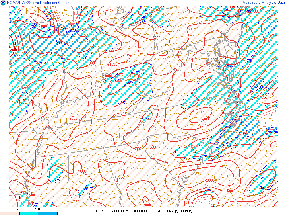
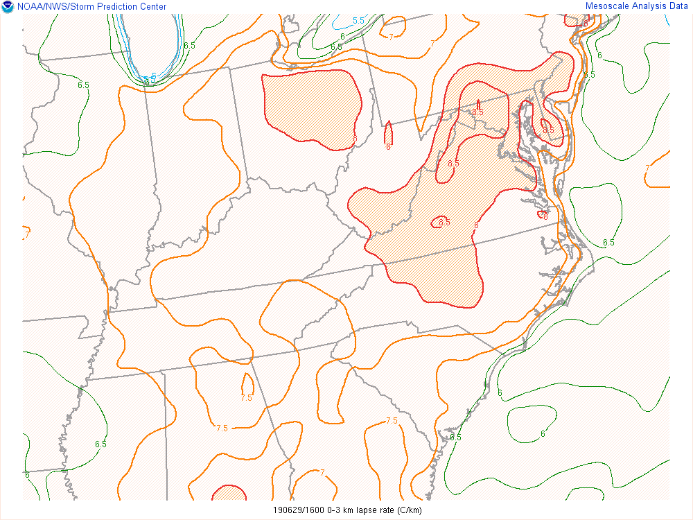
SEL2 URGENT - IMMEDIATE BROADCAST REQUESTED Severe Thunderstorm Watch Number 462 NWS Storm Prediction Center Norman OK 205 PM EDT Sat Jun 29 2019 The NWS Storm Prediction Center has issued a * Severe Thunderstorm Watch for portions of District Of Columbia Delaware Maryland Northern Virginia Eastern West Virginia Panhandle Coastal Waters * Effective this Saturday afternoon and evening from 205 PM until 700 PM EDT. * Primary threats include... Scattered damaging wind gusts to 70 mph possible Isolated large hail events to 1.5 inches in diameter possible SUMMARY...Cluster of strong thunderstorms over south-central Pennsylvania may cross into portions of Maryland and Delaware, while additional development occurs farther west. Scattered damaging winds are the primary threat. The severe thunderstorm watch area is approximately along and 40 statute miles north and south of a line from 35 miles south of Hagerstown MD to 25 miles southeast of Dover DE. For a complete depiction of the watch see the associated watch outline update (WOUS64 KWNS WOU2). PRECAUTIONARY/PREPAREDNESS ACTIONS... REMEMBER...A Severe Thunderstorm Watch means conditions are favorable for severe thunderstorms in and close to the watch area. Persons in these areas should be on the lookout for threatening weather conditions and listen for later statements and possible warnings. Severe thunderstorms can and occasionally do produce tornadoes. && OTHER WATCH INFORMATION...CONTINUE...WW 460...WW 461... AVIATION...A few severe thunderstorms with hail surface and aloft to 1.5 inches. Extreme turbulence and surface wind gusts to 60 knots. A few cumulonimbi with maximum tops to 500. Mean storm motion vector 29025. ...Grams
- 2,802 replies
-
- severe
- thunderstorms
- (and 4 more)
-
Hail 1"+ in diameter (quarter sized or greater)
- 2,802 replies
-
- severe
- thunderstorms
- (and 4 more)
-
- 2,802 replies
-
- severe
- thunderstorms
- (and 4 more)
-
SEL1 URGENT - IMMEDIATE BROADCAST REQUESTED Severe Thunderstorm Watch Number 461 NWS Storm Prediction Center Norman OK 1205 PM EDT Sat Jun 29 2019 The NWS Storm Prediction Center has issued a * Severe Thunderstorm Watch for portions of Far northern Delaware Far northeast Maryland New Jersey South-central New York Central and eastern Pennsylvania Coastal Waters * Effective this Saturday afternoon and evening from 1205 PM until 700 PM EDT. * Primary threats include... Scattered damaging wind gusts to 70 mph likely Isolated large hail events to 1.5 inches in diameter possible SUMMARY...Multiple clusters of thunderstorms will spread east across a large portion of Pennsylvania and adjacent states through early evening. Embedded strong wind gusts producing damage will be the primary hazard. The severe thunderstorm watch area is approximately along and 95 statute miles north and south of a line from 35 miles west northwest of State College PA to 20 miles south southeast of Newark NJ. For a complete depiction of the watch see the associated watch outline update (WOUS64 KWNS WOU1). PRECAUTIONARY/PREPAREDNESS ACTIONS... REMEMBER...A Severe Thunderstorm Watch means conditions are favorable for severe thunderstorms in and close to the watch area. Persons in these areas should be on the lookout for threatening weather conditions and listen for later statements and possible warnings. Severe thunderstorms can and occasionally do produce tornadoes. && OTHER WATCH INFORMATION...CONTINUE...WW 460... AVIATION...A few severe thunderstorms with hail surface and aloft to 1.5 inches. Extreme turbulence and surface wind gusts to 60 knots. A few cumulonimbi with maximum tops to 500. Mean storm motion vector 28025.
- 2,802 replies
-
- severe
- thunderstorms
- (and 4 more)
-
While it definitely doesn't look like much atm I wouldn't completely sleep on Monday. With increasing cape and modest shear if a remnant MCV moves in from the west it could spark something. Again, it's definitely not much atm but something to watch... perhaps.
- 2,802 replies
-
- severe
- thunderstorms
- (and 4 more)
-
Oh hell yeah! Those patterns brings around a lower risk of my yard being in the middle of Splitsville (as well as the negatively tilted trough pattern). It needs to come with deep-layer flow AOA 50KTS as well. Give me an 1893 Atlantic Hurricane Season repeat, an October 1878, or a Hazel. October 15, 1954 was an absolutely marvelous day in the area.
- 2,802 replies
-
- severe
- thunderstorms
- (and 4 more)
-
Psssst... We abscond the 18z hrdps.
- 2,802 replies
-
- 2
-

-

-
- severe
- thunderstorms
- (and 4 more)
-
Random note: This Thursday marks 6 years since the immediate area was last under a moderate risk.
- 2,802 replies
-
- severe
- thunderstorms
- (and 4 more)
-
If only we could get a Bill 2015 track repeat but with a very powerful southeast ridge in place. An example: Say, a category 1 landfall near Houston, TX Tuesday night, June 18, 2019. Then the fast-flow around the ridge combined with a shortwave moving in from the north slingshots it to this region by Thursday afternoon June 20, 2019 as a ~990mb low bringing backing SSE winds and upper 70's/80F dewpoints and mid 90'sF air temperatures yielding mlcape ~4000J/kg despite warm temperature profiles aloft with 50-60+kt EBWD and 250-350+ m2/s2 effective shear bringing a goodly severe threat to the region. Sorry. Weenie mode getting carried away. But you hopefully get my drift.
- 2,802 replies
-
- severe
- thunderstorms
- (and 4 more)
-
1893 tropical system tracks redux with a Hazel and 1878 track thrown in with mid 30's Celsius water temps off the SE coast and in the Gulf of Mexico please... pretty please with 22 cherries on top.
- 2,802 replies
-
- severe
- thunderstorms
- (and 4 more)
-
Mid-Atlantic summer hottest temperature contest
George BM replied to PrinceFrederickWx's topic in Mid Atlantic
BWI: 101F DCA: 104F IAD: 103F RIC: 105F SBY: 100F -
Mid-Atlantic summer hottest temperature contest
George BM replied to PrinceFrederickWx's topic in Mid Atlantic
UPDATE: BWI: 111F DCA: 114F IAD: 113F RIC: 115F SBY: 110F -
This afternoon actually seemed somewhat similar to though obviously nowhere near as widespread (wind gusts only into the 30s mph IMBY ) as the June 4, 2008 mid-afternoon event with a CAPE tongue through the region and decent enough 40-50+kt EB shear with storms decently strengthening as they got east of the mountains and into the metro region. Time of the day was similar as well though the June 4, 2008 event had more outages areawide if I remember correctly. The really impressive stuff was obviously more localized with this event.
- 2,802 replies
-
- severe
- thunderstorms
- (and 4 more)
-
45-55kt effective bulk shear as of 17z across the region.
- 2,802 replies
-
- severe
- thunderstorms
- (and 4 more)
-
It's also killing off the MCS way too fast.
- 2,802 replies
-
- severe
- thunderstorms
- (and 4 more)
-
Yeap. Our last moderate risk was actually a while ago June 13, 2013. (6 years ago)
- 2,802 replies
-
- severe
- thunderstorms
- (and 4 more)
-
Latest 12z long-range HRRR has developed storms in WV with storms also dropping towards the MD/PA line by 21z tomorrow.
- 2,802 replies
-
- severe
- thunderstorms
- (and 4 more)
-
Mid-Atlantic summer hottest temperature contest
George BM replied to PrinceFrederickWx's topic in Mid Atlantic
A temperature of 105F with a dewpoint temp of 85F will give you a @Subtropics heaven and @wxdude64 killing 140F heat index. -
FWIW (not much at this range) check out the "decent" squall line(s) on sim reflectivity through the entire region on the 0z wrf suite. Obviously far out at the end of their range though.
- 2,802 replies
-
- severe
- thunderstorms
- (and 4 more)
-
Mid-Atlantic summer hottest temperature contest
George BM replied to PrinceFrederickWx's topic in Mid Atlantic
BWI: 108F (September 25th) DCA: 110F (September 25th) IAD: 109F (September 25th) RIC: 112F (September 25th) SBY: 107F (September 25th) -
...FLASH FLOOD WATCH IN EFFECT FROM THIS EVENING THROUGH SUNDAY MORNING... The National Weather Service in Sterling Virginia has issued a * Flash Flood Watch for portions of Maryland, The District of Columbia, Virginia, and West Virginia, including the following areas, in Maryland, Anne Arundel, Carroll, Central and Southeast Howard, Central and Southeast Montgomery, Charles, Frederick MD, Northern Baltimore, Northwest Harford, Northwest Howard, Northwest Montgomery, Prince Georges, Southeast Harford, and Southern Baltimore. The District of Columbia. In Virginia, Arlington/Falls Church/Alexandria, Clarke, Culpeper, Eastern Loudoun, Fairfax, Frederick VA, Greene, Madison, Northern Fauquier, Northern Virginia Blue Ridge, Page, Prince William/Manassas/Manassas Park, Rappahannock, Rockingham, Shenandoah, Southern Fauquier, Stafford, Warren, and Western Loudoun. In West Virginia, Eastern Pendleton, Hardy, Jefferson, and Western Pendleton. * From this evening through Sunday morning * Widespread showers will develop this evening along with possible thunderstorms and locally heavy rainfall is expected. Average rainfall amounts will be between 1 and 3 inches with locally higher amounts around 4 inches possible. * Heavy rainfall in short periods of time may cause creeks and streams to rapidly rise out of their banks along with the potential for flash flooding in urban areas. PRECAUTIONARY/PREPAREDNESS ACTIONS... A Flash Flood Watch means that conditions may develop that lead to flash flooding. Flash flooding is a very dangerous situation. You should monitor later forecasts and be prepared to take action should Flash Flood Warnings be issued. && $$
- 2,802 replies
-
- severe
- thunderstorms
- (and 4 more)
-
One little note. No mesoscale model has the current activity in Eastern Ohio about to move into southwest Pennsylvania. CAPE is modest but still... it might be able to trigger something in the area later even if the current convection dies out. Just a small note. #Notanexpertopinion
- 2,802 replies
-
- severe
- thunderstorms
- (and 4 more)
-
It's a very low-key threat and more likely than not won't happen this way but a few mesoscale models try to get some remnant storms into the region tomorrow afternoon before they redevelop into asoutheastward moving storm cluster or two. This, of course, would be the most extreme case though. Just low-key watching it and exactly where the WNW to ESE oriented front sets up.
- 2,802 replies
-
- severe
- thunderstorms
- (and 4 more)
-
I wonder if you'd find any kind of damage if you went to those locations? Might be very minimal but still. *shrugs*
- 2,802 replies
-
- severe
- thunderstorms
- (and 4 more)
-
I love how some areas west of I-95 that hadn't been under a Tornado Watch since February 24, 2016 have been under 3 Tornado Watches in 12 days.
- 2,802 replies
-
- 2
-

-
- severe
- thunderstorms
- (and 4 more)


