George BM
-
Posts
3,032 -
Joined
-
Last visited
Content Type
Profiles
Blogs
Forums
American Weather
Media Demo
Store
Gallery
Everything posted by George BM
-
2020 Mid-Atlantic Severe Weather - General Thread
George BM replied to Kmlwx's topic in Mid Atlantic
I know that the post-frontal winds may be strong but... though we are not expecting much of this atm pre-cold front can you imagine if we somehow got a break in the clouds late tomorrow morning with those kind of low-level winds overhead?... Of course this is more speculative than me predicting it. -
2020 Mid-Atlantic Severe Weather - General Thread
George BM replied to Kmlwx's topic in Mid Atlantic
Even the long-range 6z hrrr (Yes, all caveats apply... end of range) shows 45-50 kt post-frontal gusts across the region. I usually find the hrrr more in line with what happens during synoptic wind events during the daylight hours. All long-range caveats aside... it looks windy tomorrow. -
2020 Mid-Atlantic Severe Weather - General Thread
George BM replied to Kmlwx's topic in Mid Atlantic
A rare Day 3 update. Day 3 Convective Outlook AMEND 1 NWS Storm Prediction Center Norman OK 0211 PM CDT Sat Apr 11 2020 ...Virginia through central and eastern Pennsylvania and New Jersey... Have expanded the SLGT risk farther north into this region. Areas of rain and thunderstorms will likely be ongoing north of a warm front from PA and NJ into southern New England. This activity will shift northeast during the morning allowing modest destabilization to occur in the pre-frontal warm sector with MLCAPE from 400-800 J/kg. Storms are expected to redevelop along cold front and in association with deeper forcing accompanying the northeast-ejecting shortwave trough. Wind profiles with 50+ kt effective bulk shear along with large 0-1 km hodographs will promote a threat for organized storms including supercells capable of damaging wind and a couple of tornadoes. -
2020 Mid-Atlantic Severe Weather - General Thread
George BM replied to Kmlwx's topic in Mid Atlantic
Psssst.... June 23rd is around the block. -
2020 Mid-Atlantic Severe Weather - General Thread
George BM replied to Kmlwx's topic in Mid Atlantic
The "obviously overdone severe-weenie" 6z 3kNAM said we get a supercell through DC tomorrow afternoon. -
2020 Mid-Atlantic Severe Weather - General Thread
George BM replied to Kmlwx's topic in Mid Atlantic
A pre-climo NW flow regime w/ potentially steep mid-level lapse rates... We watch. -
2020 Mid-Atlantic Severe Weather - General Thread
George BM replied to Kmlwx's topic in Mid Atlantic
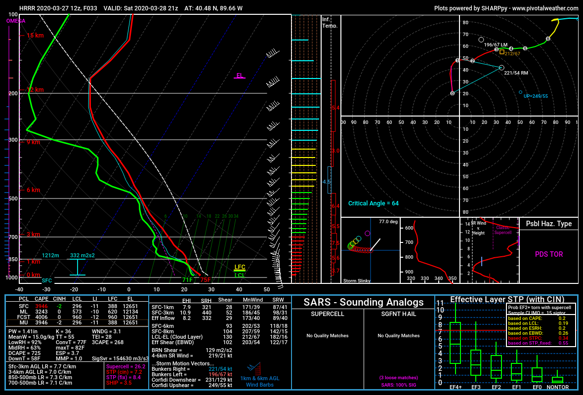
Thank for the reply. Yeah the latest long-range HRRR has some loltastic soundings. I mean check out this uncontaminated sounding below. I mean 3,000+ J/kg MLCAPE, LI near -10 with effective bulk-shear around 100kts. Lol!
-
2020 Mid-Atlantic Severe Weather - General Thread
George BM replied to Kmlwx's topic in Mid Atlantic
Now this is not for our region (SW of Chicago)... AND it's just one run from last night's 0z NAM at range but... it's not too often that you see 100+ knot EBWD with 1,000+ J/kg MLCAPE. (Also, please ignore the fact that I accidentally called these files as the 3kNAM... the images below are actually from the lower-res NAM) The following is just me thinking out loud. I'm not making assumptions about the severe threat over yonder. I wonder if 1,500+ J/kg mlcape and LIs of -5 to -6 would be enough instability for storms to not get ripped apart by this kind of shear verbatim (Is CAPE fat enough?). Yeah 1,500 J/kg mlcape is not all that weak but... that shear though... Of course I'm not trying to take away from the high-ceiling that storms will have should they take advantage of their environment. @high risk @csnavywx thoughts on this? Also I realize now that I have a problem with using too many ellipses and parentheses.
-
2020 Mid-Atlantic Severe Weather - General Thread
George BM replied to Kmlwx's topic in Mid Atlantic
Yeah. March 3rd is getting a tornadic streak lately. -
2020 Mid-Atlantic Severe Weather - General Thread
George BM replied to Kmlwx's topic in Mid Atlantic
The Tennessee tornado becomes the first violent tornado of the year in the US. -
2020 Mid-Atlantic Severe Weather - General Thread
George BM replied to Kmlwx's topic in Mid Atlantic
Clearing. -
2020 Mid-Atlantic Severe Weather - General Thread
George BM replied to Kmlwx's topic in Mid Atlantic
A low risk of some thunder and perhaps some gusty winds tomorrow depending on the amount of sunshine we can get. Low-level lapse rates look steep... with mid-level lapse rates looking somewhat steep as well. And FWIW... SPC doesn't even have us in a 10% thunder risk for tomorrow so...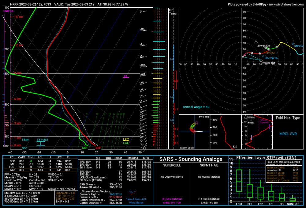
-
2020 Mid-Atlantic Severe Weather - General Thread
George BM replied to Kmlwx's topic in Mid Atlantic
If the surface low of that mid next week system can track just off to our northwest lots of models have some impressive wind fields. CAPE would be the main question though mainly because of warmer low/mid-level temperatures... and also climo in general (it's still on the early side)... Though the February 7th system probably has a few choice words for me about that "climo" statement. -
2020 Mid-Atlantic Severe Weather - General Thread
George BM replied to Kmlwx's topic in Mid Atlantic
They made a reference to that event in the 1630z update. -
2020 Mid-Atlantic Severe Weather - General Thread
George BM replied to Kmlwx's topic in Mid Atlantic
Day 2 MRGL wind in southern zones. -
2020 Mid-Atlantic Severe Weather - General Thread
George BM replied to Kmlwx's topic in Mid Atlantic
@Kmlwx Indeed I am. June 23rd is around the corner. -
2020 Mid-Atlantic Severe Weather - General Thread
George BM replied to Kmlwx's topic in Mid Atlantic
Knowing our luck... probably. My ideal pattern over the next couple months, say through June, would be for this pattern to last through early May. Then the NAO will tank to strongly negative from say May 10th onward while a ridge builds into western Canada over a trough in the western US (-EPO/-PNA) allowing for a ridge to build over the southern 1/2 to 2/3rds of the nation east of the Rockies while a trough gets locked in between the Great Lakes and Hudson Bay in response to the ridge nosing into western Canada(-EPO) AND the ridge over Greenland (-NAO). Think May 30-31, 1998 but through the Ohio Valley and Mid-Atlantic instead. -
2020 Mid-Atlantic Severe Weather - General Thread
George BM replied to Kmlwx's topic in Mid Atlantic
I just hope that we can keep this general pattern over the next couple of months. -
2020 Mid-Atlantic Severe Weather - General Thread
George BM replied to Kmlwx's topic in Mid Atlantic
This is only based off of what I personally have observed in these parts. So this is in absolutely no way expert analysis. I've noticed that the few times that we can actually do "well enough" and get close to maximizing our potential with low CAPE/high shear convective events is whenever we have a trough that tilts negative to our west with a strengthening surface low moving up the Appalachian Mountains. April 6, 2017 comes to mind. Also December 21, 2018 which probably no one remembers because the storms from this "event" only produced some brief 40-50+mph wind gusts and small hail from NVA into north/central MD and was more localized than this mornings event... but it was still at least something for late Dec and the wind profiles were weaker for that "event". This is assuming that CAD erodes quickly enough of course. I know... this is a very small sample size I'm sure there might be a few that I didn't mention. People on here who know more than me, what's your take? -
2020 Mid-Atlantic Severe Weather - General Thread
George BM replied to Kmlwx's topic in Mid Atlantic
@yodaI see that you're finally up. -
2020 Mid-Atlantic Severe Weather - General Thread
George BM replied to Kmlwx's topic in Mid Atlantic
Maybe we get our dues all at once? ...
-
I thought we had a coastal that looked like this in late January 2017 with a very similar setup that did indeed end up being all rain. I may have the year wrong though. Monday January 23, 2017. It was the one year anniversary of the 2016 blizzard and there was moderate to heavy rain with fairly strong winds through the first half of the day. Far NW areas changed over to frozen (mainly sleet iirc) and got some minor accumulations. And also, yeah, I remember a NWS disco out of ME or New England with very "irritated sounding" wording about it being late January that year yet not being able to get much in the way of any snow. ETA: Could have sworn I was in banter... sorry about that.
-
@psuhoffman I don't have anything to add but thank you so much for the time and effort put into this!
-
Congratulations!
-
Anyway, congratulations @yoda.