George BM
-
Posts
2,827 -
Joined
-
Last visited
Content Type
Profiles
Blogs
Forums
American Weather
Media Demo
Store
Gallery
Everything posted by George BM
-
There is something magical about December 5th snow indeed. The December 5th, 2002 event was the first real snow event I have vivid memory of. I just remember opening my window blinds in my apartment in Falls Church as a six-year old looking at this mysterious, bright, radiant, white landscape. It was surreal... almost like I'd been teleported to a foreign planet. Thus further sparking my interest in the wintery aspects of weather. Of course, after that we would see 4 more "first snow on December 5th events" within the following seven years.
-
The southeastern sky was a fiery orangeish/pinkish for a good, long 30+ minutes before the sun broke the horizon. A beauty indeed.
-
e16 and e17 FTW... for the coastal Carolinas.
-
I recently noticed the free ECMWF maps on pivotal. Wow, what a game changer.
-
Lol! What could've been.
-
Just me being Curious George here... Other than the June 29, 2012 derecho (we all know that that's one of the two events you're referring to) what was the other widespread severe event in your 41 years here?
-
Windy with falling temperatures.
-
Just hit a daily high of 78F at IAD.
-
60/30 TOR Probs... with 90/40 wind probs...
-
Meanwhile we remain "King of the Fake Droughts".

-
Already up to 70/67 at IAD as of 9:44am edt.
-
Oh yeah... this thread exists.
- 2,802 replies
-
- 1
-

-
- severe
- thunderstorms
- (and 4 more)
-
Though there was no Tornado Watch then, there were the quick spin-up EF-1 QLCS tornadoes in Maryland last November. 65/56 at IAD currently with thickening clouds.
-
The alluding to Halloween portion of the disco: "Everyone should make sure they have a way to receive warnings and get to shelter quickly should severe weather threaten your neighborhood tomorrow evening."
-
Yeah that's true. I also prefer the daytime to be able to see the action clearly... whatever action there may be. That's just me personally though.
-
With preference for the latter of course for the best heating.
-
HRRR at range of course but the 12z says sorry trick or treaters west of I-95.
-
Probably April 27-28, 2011.
-
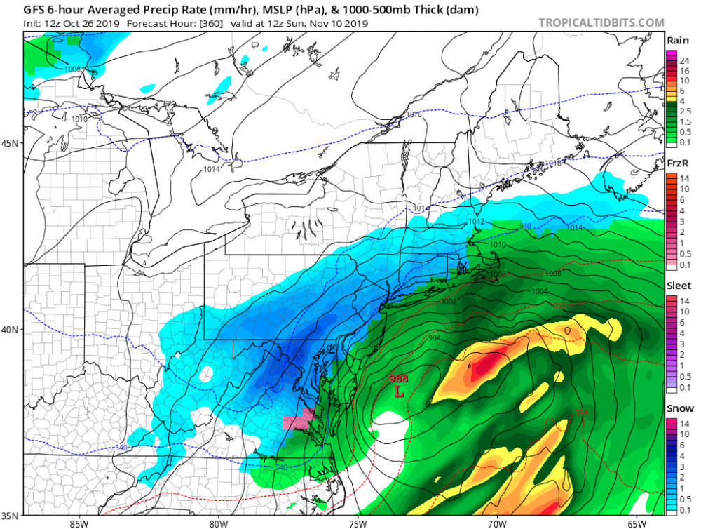
Widespread severe winds from cold front forced "storms" are so rare at this time of the year unless we can get an October 2010-like bomb to bomb out further east through the Ohio Valley, Great Lakes, interior Northeast region. That worked out well from the Midwest into the Ohio Valley then. But of course you all probably know that. Just rambling.
-
I too remember that day. I just remember it raining heavily at times (with some lightning early in the afternoon) through about 3pm followed by skies rapidly clearing for late afternoon sunshine. That day was certainly nothing compared to your favorite event two springs later on a June 4th afternoon. I wouldn't make it out of school to see that one though.
-
Would be interesting to get the line through the region between 6 and 9pm.
-
Day 2 Convective Outlook NWS Storm Prediction Center Norman OK 1225 PM CDT Sat Oct 26 2019 Valid 271200Z - 281200Z ...Shower activity ahead of the main frontal convection will limit instability and heating across northern and central VA northward. However, surface dewpoints in the mid to upper 60s are forecast, resulting in SBCAPE less than 250 J/kg across northern VA into the northern Chesapeake Bay vicinity. Ahead of the front, backed southeasterly winds in the vicinity of a pre-frontal trough will result in effective shear values around 30-40 kt. This should allow for some organized bowing segments within the QLCS and a few damaging wind gusts will be possible as convection quickly moves east/northeast. Strong wind profiles as low as around 1000 feet, and backed southeast surface winds will lead to large, curved hodographs. If pockets of greater instability occur and surface-based convection develops, a weak/brief tornado cannot be ruled out across northern VA toward coastal MD....
-