

George BM
-
Posts
3,055 -
Joined
-
Last visited
Content Type
Profiles
Blogs
Forums
American Weather
Media Demo
Store
Gallery
Everything posted by George BM
-
2020 Mid-Atlantic Severe Weather - General Thread
George BM replied to Kmlwx's topic in Mid Atlantic
Being in a spot that normally misses out on storms this evenings storm was a decent one my MBY standards. Sheets of rain w/ 40+ mph wind gusts at times. Better than normal for MBY. -
2020 Mid-Atlantic Severe Weather - General Thread
George BM replied to Kmlwx's topic in Mid Atlantic
https://www.earthcam.com/usa/newjersey/seasideheights/?cam=seasideheights Next in line. -
2020 Mid-Atlantic Severe Weather - General Thread
George BM replied to Kmlwx's topic in Mid Atlantic
Yeap. I haven't noticed any lightning though. -
2020 Mid-Atlantic Severe Weather - General Thread
George BM replied to Kmlwx's topic in Mid Atlantic
https://www.earthcam.com/usa/pennsylvania/philadelphia/?cam=philly Enjoy. -
2020 Mid-Atlantic Severe Weather - General Thread
George BM replied to Kmlwx's topic in Mid Atlantic
Verbatim, it would be a nice fast-moving line with good wind potential if CAPE ended up better than modeled... not that I'm implying that it will be. -
2020 Mid-Atlantic Severe Weather - General Thread
George BM replied to Kmlwx's topic in Mid Atlantic
-
2020 Mid-Atlantic Severe Weather - General Thread
George BM replied to Kmlwx's topic in Mid Atlantic
Congrats intermountain NW?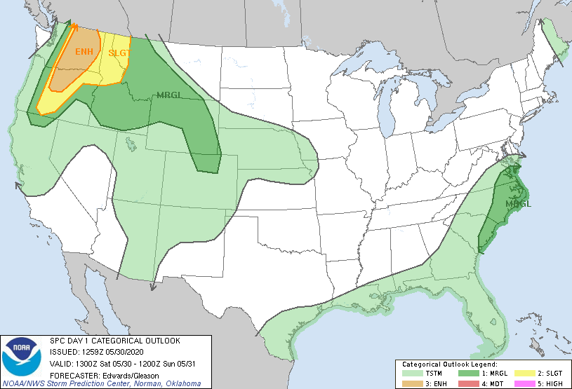
-
2020 Mid-Atlantic Severe Weather - General Thread
George BM replied to Kmlwx's topic in Mid Atlantic
I'm just glad that I was not old enough (4 years old) to remember that debacle of an 'event'. -
2020 Mid-Atlantic Severe Weather - General Thread
George BM replied to Kmlwx's topic in Mid Atlantic
Yeap. URGENT - IMMEDIATE BROADCAST REQUESTED SEVERE THUNDERSTORM WATCH NUMBER 666 STORM PREDICTION CENTER NORMAN OK 1219 PM EDT WED AUG 9 2000 THE STORM PREDICTION CENTER HAS ISSUED A SEVERE THUNDERSTORM WATCH FOR PORTIONS OF DISTRICT OF COLUMBIA MARYLAND SOUTHERN PENNSYLVANIA NORTHERN VIRGINIA CENTRASL AND EASTERN WEST VIRGINIA EFFECTIVE THIS WEDNESDAY AFTERNOON AND EVENING FROM 100 PM UNTIL 700 PM EDT. ...THIS IS A PARTICULARLY DANGEROUS SITUATION... DESTRUCTIVE WINDS. ALSO...HAIL TO 1 INCH IN DIAMETER... THUNDERSTORM WIND GUSTS TO 95 MPH...AND DANGEROUS LIGHTNING ARE POSSIBLE IN THESE AREAS. THE SEVERE THUNDERSTORM WATCH AREA IS ALONG AND 70 STATUTE MILES NORTH AND SOUTH OF A LINE FROM 60 MILES WEST SOUTHWEST OF MORGANTOWN WEST VIRGINIA TO 10 MILES EAST SOUTHEAST OF BALTIMORE MARYLAND. REMEMBER...A SEVERE THUNDERSTORM WATCH MEANS CONDITIONS ARE FAVORABLE FOR SEVERE THUNDERSTORMS IN AND CLOSE TO THE WATCH AREA. PERSONS IN THESE AREAS SHOULD BE ON THE LOOKOUT FOR THREATENING WEATHER CONDITIONS AND LISTEN FOR LATER STATEMENTS AND POSSIBLE WARNINGS. OTHER WATCH INFORMATION... CONTINUE...WW 665... DISCUSSION...INTENSE BOW ECHO OVER SERN OHIO IS EXPECTED TO CONTINUE EWD AT 55 KT ACROSS THE APPALACHIANS WITH WIDESPREAD DAMAGING WINDS LIKELY. ACTIIVTY WILL REACH THE BALTIMORE/WASHINGTON DC AREA AROUND 5 PM. AVIATION...A FEW SEVERE THUNDERSTORMS WITH HAIL SURFACE AND ALOFT TO 1 INCH EXTREME TURBULENCE AND SURFACE WIND GUSTS TO 80 KNOTS. A FEW CUMULONIMBI WITH MAXIMUM TOPS TO 500. MEAN STORM MOTION VECTOR 27055. -
2020 Mid-Atlantic Severe Weather - General Thread
George BM replied to Kmlwx's topic in Mid Atlantic
August. August 9, 2000 to be exact. It was even Severe Thunderstorm Watch 666. Lol. -
2020 Mid-Atlantic Severe Weather - General Thread
George BM replied to Kmlwx's topic in Mid Atlantic
For todays risk look out for how much high level cloud cover we get from the storms currently developing in the Carolinas. -
2020 Mid-Atlantic Severe Weather - General Thread
George BM replied to Kmlwx's topic in Mid Atlantic
There hasn't been a MOD or HIGH risk issued anywhere in the country this month from SPC. Quiet indeed. One time period that I'll watch is following the cool shot at the beginning of next week. As a ridge tries to build in during the week watch for any potential NW-flow event. Small note: Some of the 0z convective models hint at scattered storms/convection trying to develop tomorrow afternoon from Bertha. There looks like there will be some low-level shear (not super impressive LLshear but some LLshear). If storms can develop tomorrow there might be a risk of gusty winds and perhaps a rotating meso or two. #Notanexpertopinion -
2020 Mid-Atlantic Severe Weather - General Thread
George BM replied to Kmlwx's topic in Mid Atlantic
That's what pulled my arm enough for me to make the post about Sundays potential. -
2020 Mid-Atlantic Severe Weather - General Thread
George BM replied to Kmlwx's topic in Mid Atlantic
For the past several days I've been low-key watching the Sunday system for any severe potential and as of right now late Sunday has slight potential to get interesting should we have enough CAPE (which currently looks modest to perhaps locally moderate with LI of -3 to -5). Deep layer flow looks fairly strong (on the order of 50+ kts in the mid-levels). Should we be able to get enough sunshine for more moderate CAPE it could get interesting for some. Timing does look to be leaning a bit on the later side ATM. Then there is also still the question of how far north this 'threat' will extend. #Notanexpertopinion #Justmy2cents -
2020 Mid-Atlantic Severe Weather - General Thread
George BM replied to Kmlwx's topic in Mid Atlantic
While just about all ensembles have this trough staying over the eastern US for the remainder of the month into the beginning May I wonder if we can get into some W/NW flow action sometime early in May (2nd week?) as the trough slowly lifts and/or shifts eastward (as shown in a number of long range ens. ATM). Just speculation at this point of course... and me thinking out loud. -
2020 Mid-Atlantic Severe Weather - General Thread
George BM replied to Kmlwx's topic in Mid Atlantic
A pretty decent gust-front just went through Charles Town looking at the radar. What would you guesstimate the strength of the gusts to be? -
2020 Mid-Atlantic Severe Weather - General Thread
George BM replied to Kmlwx's topic in Mid Atlantic
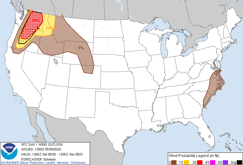
The DC metro is now within the SLGT risk. 0% Tornado/ 15% Wind/ 0% Hail -
2020 Mid-Atlantic Severe Weather - General Thread
George BM replied to Kmlwx's topic in Mid Atlantic
Don't completely sleep on this Tuesday either. There could be some low-topped convection with limited CAPE along and just ahead of the cold front. Steep low-level lapse rates and fairly fast-flow aloft could translate to some of the convection having strong wind gusts. -
2020 Mid-Atlantic Severe Weather - General Thread
George BM replied to Kmlwx's topic in Mid Atlantic
This shows that we at least have a non-zero severe chance through the end of April. -
2020 Mid-Atlantic Severe Weather - General Thread
George BM replied to Kmlwx's topic in Mid Atlantic
Even the April 6, 2017 had fairly widespread strong winds and seven EF-0 tornadoes in northern VA... this with less than 250J/kg MUCAPE. That June 13, 2013 event could have been a memorable event area-wide if the morning MCS didn't hamper things. It was also the last time we had a moderate risk in the immediate region though it was downgraded to a SLGT at 1630z due to said morning MCS leaving us with AOB 1000 J/Kg MLCAPE. This is my opinion (not an expert): When dealing with a W/NW flow event with a fairly strong low-pressure system within the flow there will very often be a morning/early day MCS. This is because the previous days storms that develop in the Midwest often grow upscale during the evening and are able to survive the whole night due to the better dynamics and CAPE. With the forward speed that these MCSs usually have they very often reach us during the morning hours. An ideal thing with these regimes would be either the timing being a few hours faster so that we can get more midday/solar noon sunshine to destabilize the atmosphere more quickly for any later day activity (easier option) or a heat-dome already being in place so that any morning event would stay to the north while the low-pressure system approaches from the W/NW spawning another MCS (or just decent storms in general) during the afternoon to cruise through the region during the afternoon/evening (harder to pull off option). -
2020 Mid-Atlantic Severe Weather - General Thread
George BM replied to Kmlwx's topic in Mid Atlantic
Thank you both for the replies. -
2020 Mid-Atlantic Severe Weather - General Thread
George BM replied to Kmlwx's topic in Mid Atlantic
Sorry for the novice question but how do I read this? Is this showing the expected surface wind speed and direction at various times? -
2020 Mid-Atlantic Severe Weather - General Thread
George BM replied to Kmlwx's topic in Mid Atlantic
Mesoscale Discussion 0360 NWS Storm Prediction Center Norman OK 0426 PM CDT Sun Apr 12 2020 Areas affected...south-central and southeast Mississippi Concerning...Tornado Watch 106...107... Valid 122126Z - 122200Z The severe weather threat for Tornado Watch 106, 107 continues. SUMMARY...Based on recent radar and environmental data, a violent tornado with potential peak winds of 170 to 205 mph (EF4-EF5) is likely ongoing. THIS IS AN EXCEPTIONALLY RARE EVENT. DISCUSSION...An intense supercell will continue to move through a favorable environment over south-central Mississippi, characterized by 0-1 km SRH around 400 m2/s2 and MLCAPE near 2000 J/kg per latest mesoanalysis data. Recent radar signatures from KLIX as of 2112Z reveal an intense supercell characterized by a 0.4 degree rotational velocity of at least 70 kt. A tornadic debris signature has also been noted on recent radar scans. These signatures are occurring in an environment characterized by STP greater than 7. Previous signatures within similar environments produced tornado-damage-estimated wind speeds from 170 to 205 mph and confidence is high for a likely violent tornado. A long-track tornado is expected to continue based on the rotational velocity duration and the storm moving within a favorable downstream environment. -
2020 Mid-Atlantic Severe Weather - General Thread
George BM replied to Kmlwx's topic in Mid Atlantic
Also RAP'd. -
2020 Mid-Atlantic Severe Weather - General Thread
George BM replied to Kmlwx's topic in Mid Atlantic
I know that the post-frontal winds may be strong but... though we are not expecting much of this atm pre-cold front can you imagine if we somehow got a break in the clouds late tomorrow morning with those kind of low-level winds overhead?... Of course this is more speculative than me predicting it.

