George BM
-
Posts
2,827 -
Joined
-
Last visited
Content Type
Profiles
Blogs
Forums
American Weather
Media Demo
Store
Gallery
Everything posted by George BM
-
I haven't really stepped into this much vocally (there are lots on here that look way more indepth to this and have added some great info) but while the deceleration in the rate of the increasing number of daily new cases is a good thing to see... that might just be that only so many people are being tested in a day. I mean we all know that there are probably millions who already have it (I know... not exactly big news (limited testing availability)). But the daily death rate is probably more representative of how things are shaping up here. This, of course, is just my opinion.
-
...With fairly decent storms to the north.
-
2020 Mid-Atlantic Severe Weather - General Thread
George BM replied to Kmlwx's topic in Mid Atlantic
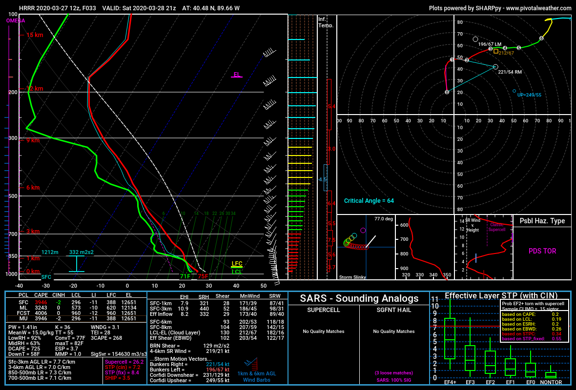
Thank for the reply. Yeah the latest long-range HRRR has some loltastic soundings. I mean check out this uncontaminated sounding below. I mean 3,000+ J/kg MLCAPE, LI near -10 with effective bulk-shear around 100kts. Lol!
-
2020 Mid-Atlantic Severe Weather - General Thread
George BM replied to Kmlwx's topic in Mid Atlantic
Now this is not for our region (SW of Chicago)... AND it's just one run from last night's 0z NAM at range but... it's not too often that you see 100+ knot EBWD with 1,000+ J/kg MLCAPE. (Also, please ignore the fact that I accidentally called these files as the 3kNAM... the images below are actually from the lower-res NAM) The following is just me thinking out loud. I'm not making assumptions about the severe threat over yonder. I wonder if 1,500+ J/kg mlcape and LIs of -5 to -6 would be enough instability for storms to not get ripped apart by this kind of shear verbatim (Is CAPE fat enough?). Yeah 1,500 J/kg mlcape is not all that weak but... that shear though... Of course I'm not trying to take away from the high-ceiling that storms will have should they take advantage of their environment. @high risk @csnavywx thoughts on this? Also I realize now that I have a problem with using too many ellipses and parentheses.
-
MD schools closed through April 24th.
-
Yesterday I went for a walk around my neighborhood and I've never seen so many people/families out and about just walking. Obviously the 80 degree Fahrenheit weather had a big hand in that. I kept a safe distance from others.
-
There's actually a gust front with this rain/sleet activity. Temp at IAD just fell from 54F to 47F. I saw gusts of 25-30 mph.
-
@MillvilleWx How many tornado warnings did your WFO issue during the past 12-24 hours?
-
Corona virus tracking is the new thing these days.
-
I'm pulling for your mother to make a full recovery.
-
I echo everyone else on here in saying I hope you make a full recovery.
-
Absolutely definitely.
-
Official twitter statement.
-
-
Gunny. I thought that the clouds had a bit of a smoky look to them... though I'm at the west end of Fairfax county with winds in the lower-levels of the atmosphere out of the west. So it may be my imagination after all... hopefully... there was an area of smoke rising from about a mile or a few NNW of the Costco in Sterling, VA as I was leaving there around 5:30pm... 61/12 at IAD currently. A 49F dewpoint depression and 14% relative humidity. Great day for outside burning.
-
Just got a burst of heavy graupel from said cell in Herndon, VA. Neat.
-
2020 Mid-Atlantic Severe Weather - General Thread
George BM replied to Kmlwx's topic in Mid Atlantic
Yeah. March 3rd is getting a tornadic streak lately. -
How many are showing up to the ceremony?
-
2020 Mid-Atlantic Severe Weather - General Thread
George BM replied to Kmlwx's topic in Mid Atlantic
The Tennessee tornado becomes the first violent tornado of the year in the US. -
Me thinks some get too heated over things that don't affect them.
-
2020 Mid-Atlantic Severe Weather - General Thread
George BM replied to Kmlwx's topic in Mid Atlantic
Clearing. -
2020 Mid-Atlantic Severe Weather - General Thread
George BM replied to Kmlwx's topic in Mid Atlantic
A low risk of some thunder and perhaps some gusty winds tomorrow depending on the amount of sunshine we can get. Low-level lapse rates look steep... with mid-level lapse rates looking somewhat steep as well. And FWIW... SPC doesn't even have us in a 10% thunder risk for tomorrow so...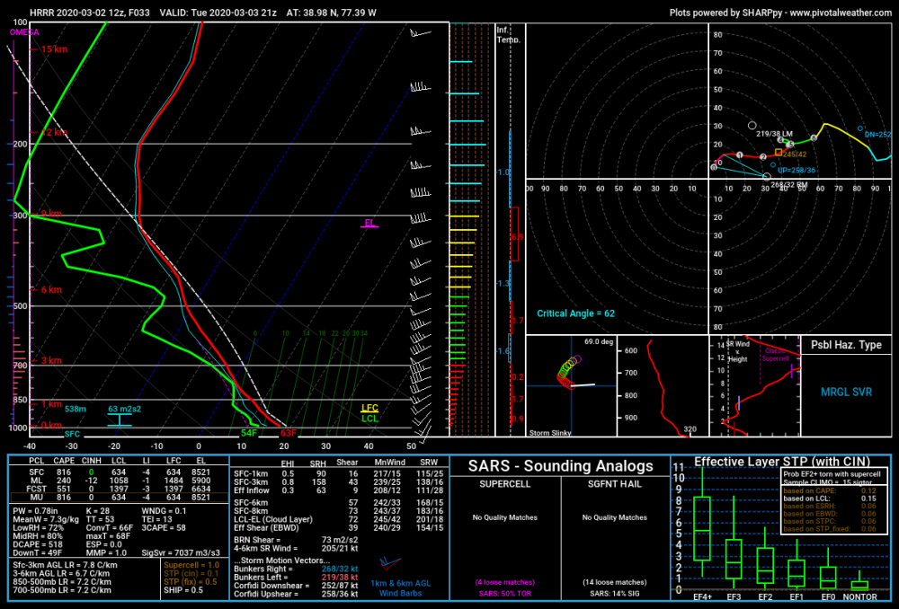
-
Drink safely!