George BM
-
Posts
2,835 -
Joined
-
Last visited
Content Type
Profiles
Blogs
Forums
American Weather
Media Demo
Store
Gallery
Everything posted by George BM
-
@EastCoast NPZ Any luck with those storms currently in your area?
-
2021 Atlantic Hurricane Season Tracking Thread
George BM replied to WxWatcher007's topic in Mid Atlantic
Yes. It's your turn. -
I was mowing my yard earlier and I too heard my first annual cicada.
-
Happy 9 year anniversary to you all!
-
@mappy I've heard rumblings that today is a special day for you? I hope you've been enjoying the big day.
-
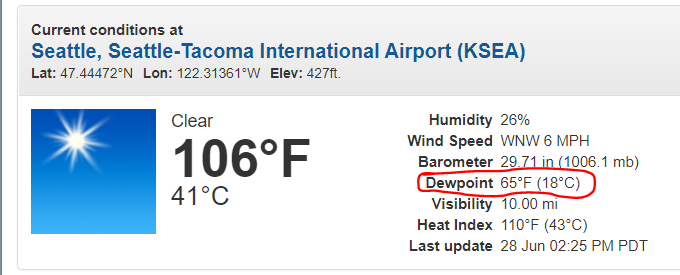
The short term section of the AFD issued by SEW... yeap. 000 FXUS66 KSEW 262245 AFDSEW Area Forecast Discussion National Weather Service Seattle WA 345 PM PDT Sat Jun 26 2021 .SYNOPSIS...Record breaking heat is already underway as the strong ridge overhead intensifies over the next few days. Temperatures will peak tomorrow and Monday before meaningful onshore flow acts to cool down the region on Tuesday. Temperatures will not likely cool back down to normal for this time of year and will remain above average through next week. && .SHORT TERM /TONIGHT THROUGH TUESDAY/...Record breaking temperatures have been recorded across western Washington this afternoon, yet it is still early on in the heat event. With Sea- Tac recording 99 degrees, it becomes the hottest June day on record, but the next two days look to once again break those records and then likely breaking into all time record territory. Relief from the hot temperatures are certainly not likely overnight in terms of the overnight lows over the next two days either, as record high low temperatures in the 70s are expected. Coastal locations are also going to be hot, but likely peaking on Sunday as the thermal trough along the coast is going to go through the area on Monday and help initiate some cooling onshore flow. Monday will likely be the hottest day for the interior as that thermal trough sets up more over the I-5 corridor. It is quite unbelievable to have 108-110 in the forecast for Monday in and around SeaTac, but that is a testament to the strength of this ridge. Furthermore, it is exceedingly difficult to forecast the nuances for an event such as this one for which there is no good analog or comparison for in recent climatological recollection. The excessive heat warning remains in effect for western Washington. Those without access to proper cooling and hydration will remain most at risk for heat illness and related complications through the weekend and into early next week. Check with local municipalities and county authorities for information on cooling centers for those without air conditioning. Here are some additional tips for staying safe in the heat: -Avoid strenuous activity and limit time outdoors, especially in the peak heating of the day. Without overnight relief from the heat, a general time frame to avoid the outdoors is between 9am- 6pm. -Make sure to stay hydrated and to drink enough water before feeling thirsty. -Check on family, friends, neighbors, and those who do not have access to proper cooling.
-
A record that will likely stand for less than 24 hours.
-
Yeap. July 16, 2010 at 5:04am local time. It was a magnitude 3.6?... IIRC.
-
2021 Atlantic Hurricane Season Tracking Thread
George BM replied to WxWatcher007's topic in Mid Atlantic
Probably nothing happens but the area of thunderstorms SE of Bermuda with a weak surface trough and a bit of an ULL shows that SSTs are slowly heating up for the season. -
I love Gravelly Point as well when I spot.
-
One degree warmer this morning than yesterday, at 50 for IADs low.
-
2021 Mid-Atlantic Severe Weather - General Discussion
George BM replied to Kmlwx's topic in Mid Atlantic
I'm seeing 70+ mph a few thousand feet off of the surface with that one on radarscope. -
2021 Mid-Atlantic Severe Weather - General Discussion
George BM replied to Kmlwx's topic in Mid Atlantic
I certainly don't hate the storm cluster that the HRRR has been advertising moving through the region late this afternoon. Other 0z CAMs to a slightly lesser extent showed a similar thing. Much like what csnavywx hinted at above. I don't hate the large DCAPE and 30-40kt mid-level flow showing up on CAMs either (Wind potential). Fingers crossed. -
2021 Mid-Atlantic Severe Weather - General Discussion
George BM replied to Kmlwx's topic in Mid Atlantic
Yes. I've noticed that some models have looked a bit more 'sheary' than usual for the time of year in the long range. Fingers, toes, arms, legs and anything you can cross crossed. -
2021 Mid-Atlantic Severe Weather - General Discussion
George BM replied to Kmlwx's topic in Mid Atlantic
I'm actually lowkey watching Monday. Some CAMs are hinting that MLLRs may steepen during the day with moisture from Claudette in the lower levels leading to higher CAPE. At the same time shear looks to strengthen to modest/moderate levels. If storms can form along the surface trough near the mountains on Monday and/or organized storm activity from further west can propagate eastward into the region, the ingredients may be there for a few decent storms. -
Currently 73/41 at IAD. G------- It's simply g------- What a g------- It seems that that G-word has been used too much for this board's software to handle. But I think you all know what I was trying to say. Actually, how about this other g-word that's been used slightly less. Glorious... Hey it wasn't cut out! Let's try this again. ... Currently... well now 73/40 at IAD. It's simply glorious.
-
With how severe the drought is out west and with the ridge being favored in that area at least through much of the month, I wonder if we see a bit of a feedback loop this summer with the drought out west allowing for quicker heating during the day leading to stronger ridges out there and more troughing in the east? Just a thought that I've pondered lately. I mean obviously there will occasionally be an eastern ridge and a western trough this summer. I'm probably thinking too simply.
-
2021 Mid-Atlantic Severe Weather - General Discussion
George BM replied to Kmlwx's topic in Mid Atlantic
-
2021 Mid-Atlantic Severe Weather - General Discussion
George BM replied to Kmlwx's topic in Mid Atlantic
Venting section: It's early indeed and no two systems are the exact same. But I literally (Yeah... I said 'literally'. Don't cringe too hard.) was just thinking about the bolded statement and how it's these kind of potential events that are NOTORIOUS for screwing us over with early day cloud cover and/or convection that takes too long to clear out. (Think a 6z day 1 ENH+ for the region that becomes a 1630z or 20z Day 1 MRGL). Non-venting section: Saturday definitely looks like the kind of day that would have 'higher than normal' severe potential if we don't get those infamous morning shenanigans mentioned in the above paragraph ruining steeper than normal MLLRs/EML given the likely swift deep-layer flow. As always... fingers crossed. -
2021 Atlantic Hurricane Season Tracking Thread
George BM replied to WxWatcher007's topic in Mid Atlantic
We need to get a time machine and teleport back to this moment 49 years ago and live those following ten days out. -
2021 Atlantic Hurricane Season Tracking Thread
George BM replied to WxWatcher007's topic in Mid Atlantic
Lol. I should've added the /s or or something like that. -
2021 Atlantic Hurricane Season Tracking Thread
George BM replied to WxWatcher007's topic in Mid Atlantic
@WxWatcher007 Nope. It's spot on. Notice the areas that get the highest impact. Get ready now SE subforum folks. -
2021 Atlantic Hurricane Season Tracking Thread
George BM replied to WxWatcher007's topic in Mid Atlantic