George BM
-
Posts
2,835 -
Joined
-
Last visited
Content Type
Profiles
Blogs
Forums
American Weather
Media Demo
Store
Gallery
Everything posted by George BM
-
Same here so far. The smoke will be thickest tomorrow both aloft and near the surface.
-
2021 Atlantic Hurricane Season Tracking Thread
George BM replied to WxWatcher007's topic in Mid Atlantic
Regardless of your thoughts about this upcoming winter, this post actually fits well in this thread for other obvious reasons. IF ASO end up looking like this, things may be a bit more interesting. Hey, an extreme weather weenie can can always dream and cross his fingers. -
Becoming increasingly smoky aloft from this evening onwards. Tomorrow will be hazy with smoke aloft.
-
Hence my "Enjoy. " Remark. Really hope your luck changes.
-
@EastCoast NPZ Enjoy.
-
That 25-27K theta-e difference. Is that between the 1000mb and 500mb level?
-
Suddenly your display name makes sense.
-
2021 Mid-Atlantic Severe Weather - General Discussion
George BM replied to Kmlwx's topic in Mid Atlantic
Personal amateur thoughts (correct me where needed): Yeah. That I-66 line was doomed once the southern storms quickly matured (close enough to the I-66 line to rob it of lift.) They would also have to deal with the high clouds blowing northwards from the southern storms blocking sunshine from reaching the surface stunting low-level mixing, again, making storm survival more difficult. The gust front from the southern storms sealed the deal. -
I just hope that those of us, especially west of I-95 can cash in on a south to north moving band of heavy rain/thunderstorms this afternoon with gusty winds. There should be moderate CAPE ahead of the cloud/rain shield given higher low-level moisture content and limited sunshine developing across Virginia. It would at least seem tropical for a bit.
-
Nah. You're perfectly safe posting any beer choices you please. I'd use extreme caution when posting your preferred Weenie-Os choices though.
-
2021 Atlantic Hurricane Season Tracking Thread
George BM replied to WxWatcher007's topic in Mid Atlantic
You probably know this but Elsa is a hurricane again. BULLETIN Hurricane Elsa Intermediate Advisory Number 27A NWS National Hurricane Center Miami FL AL052021 800 PM EDT Tue Jul 06 2021 ...ELSA REGAINS HURRICANE STATUS SOUTHWEST OF TAMPA BAY... ...RECONNAISSANCE AIRCRAFT EN ROUTE TO INVESTIGATE THE HURRICANE... SUMMARY OF 800 PM EDT...0000 UTC...INFORMATION ---------------------------------------------- LOCATION...26.6N 83.1W ABOUT 100 MI...165 KM SSW OF TAMPA FLORIDA MAXIMUM SUSTAINED WINDS...75 MPH...120 KM/H PRESENT MOVEMENT...N OR 360 DEGREES AT 14 MPH...22 KM/H MINIMUM CENTRAL PRESSURE...996 MB...29.41 INCHES -
@WxWatcher007 Shot. Forgot to wish you a great day yesterday. I hope it was awesome. May you experience the eyewall of a cat 5 that would make even the most extreme storm chasers jealous.
-
Not to worry, friend. The DC split cannot hurt us in the George BM universe.
-
2021 Atlantic Hurricane Season Tracking Thread
George BM replied to WxWatcher007's topic in Mid Atlantic
FWIW, the 12z Canadian is similar. -
NA101: Oh man its about to hit me here. I HATE big wind. I’ll just hang out in my basement and hope the house isn’t completely screwed up when I come back out. George BM: I have a few minutes left before it hits here. You can see all the layers of pancakes above the shelf cloud on the horizon here. I can’t even see the bottom of the shelf yet (trees in the way) but it’s only about 3-4 minutes away. ETA: And now I’m hearing the distance roar. NoVaWx: My goodness! Trees falling all over the place and BIG limbs flying through the air! I’m even seeing some siding flying around! Power is gone! Waterboy: I brought in everything that can be blown away. I’m debating bringing my pillows into the downstair bathroom. George BM: Unreal winds here now! These seem like 70-80+ mph gusts to me. Trees are falling everywhere! ETA: Whiteout rains have just hit and the winds have increased further (90+ mph)! The house is making all kinds of noise I’ve never heard it make before. Snowenoverthere: Well there goes all of the firework shows for tonight. Hourlylurker: All these adrenline-pumping reports to my northwest! Christmas in July! WOOOOOOOOOOOOOOOOOOOOOOOOOOOOOOOOOOOO!!!
-
EastCoastDesert: All I’m asking for is enough rain for me to not have to water my garden this evening. ETA: I’m starting to hear the roar to my north w/ the gust front probably still 2-3 miles away. Mrs. J: Sweet mother of pearl! I’m going to the basement! Baby Yoda: @Mrs. J Stay safe! Lwxkm: 100-120+mph velocity estimates in her zone. NWBaltimore: Okay, the power just came back on here so I’m just now hearing about the tornado reports through Morrell Park. I have big tree limbs down IMBY with a few trees down throughout the neighborhood. That’s a nasty looking bookend vortex developing to my northwest. We’re just getting started here. Losttoa6: Wow! The storm started about 5 minutes ago here and I’m contemplating going to my basement. Winds probably 80-90+mph with many trees already down everywhere I look and huge limbs flying everywhere! I don’t know how I still have power. Aaaand there it goes just as I type this lol. ETA: Just heard glass shatter! into the basement I go. Ji: This storm is using up all of our HECS jojo for the next decade. Mega-disaster as usual. Baby Yoda: The STW across northwestern areas just got updated now saying 100mph wind gusts and half-dollar hail. George BM: @Baby Yoda

-
Mrs. J: Just got an EAS on my phone! Scared the living daylights outta me. Losttoa6: Whoa! An EAS for a Severe Thunderstorm Warning? Baby Yoda: STW for 90 mph wind gusts and half-dollar size hail! This includes pretty much everyone Gaithersburg, Leesburg, Purcellville and all areas of MD northwest until 6pm. Warning has the line moving at 70mph! The storms are still in PA about to cross the MD/PA line. Joe the Eskimo: @Baby Yoda TrickC: I’ve said it before and I’ll say it again. Wind is the most useless kind of weather. Alpha: Wow! Do ANY of you actually own a house? Why are you all simping for death and destruction? Losers. Hourlylurker: @Alpha Yeah no. This is a place where people have a passion for experiencing extreme weather, some more than others. Someone’s want for storms has zero effect on what happens with Mother Nature. NWBaltimore: Getting pounded by very large hail here now with this supercell. Probably Golfball sized. ETA: It just got tornado warned. Alpha: @Hourlylurker Great to see that you have no compassion for others. I’ve gone through hurricanes down here. Many of them last year. Why would you psychopaths want any of the death and heartache that comes with storms of this magnitude? Baby Yoda: Tornado Warning now on the Baltimore supercell. Radar indicated but there is a growing couplet over Forest Park Golf Course moving towards Franklin. Hourlylurker: @Alpha Lol! So, if you have any kind of fascination of experiencing big storms you’re a human hating psychopath. Got it! KW: @Alpha If you’re just going to come here to call people names expect your posts to disappear quick. Alpha: Whatever. I’ll go join the adults back in my subforum now. Midatlanticwx: @Alpha Dr. Reaper: Alpha, no one here is gloating over the number of deaths that occur in a storm. A lot of people on here enjoy the thrill of experiencing big storms. Yes, they can sometimes damage or destroy neighborhoods. They can sometimes lead to loss of life. But I VERY HIGHLY doubt that people are on here thinking “Yes, let’s see how expensive this storm may be for life and property around my area. I’m excited to see the death toll from these storms.” No. We only enjoy the thrill of experiencing a powerful storm… the kind you hear about on the radio and/or on the news. Yes, it would be preferable if storms only hit low population zones like, for example, tornadoes mowing over open fields in the Great Plains. But powerful storms do hit populated regions due to random chaos. Storms were around long before we humans were. They are just a force of nature that doesn’t give one lick about how you or I or anyone feels about them. PrinceFredrick: That couplet by Baltimore is starting to look stronger. Baby Yoda: NWS George BM Headquarters Flash Flood Watch in effect until midnight EDT tonight. A line of severe thunderstorms will move through our region from northwest to southeast through the afternoon and evening. Although the line will be moving quickly Pwats of up to 2.5 inches will allow these storms to have very heavy rainfall rates. A quick 1.5 to 3 inches of rain could fall as they move through. Locally higher amounts of 4+ inches are possible wherever the line becomes oriented more parallel to the flow. This is most likely in the Shenandoah Valley and up towards Baltimore and southeastwards across the bay. Rivers and streams may rise very quickly out of their banks. Always turn around and do not drown. Mattie: @Baby Yoda A couple inches isn’t enough to save us from the catastrophic drought. PrinceFredrick: @Dr. Reaper Nah. We all know that @Waterboy was around well before the first storm landed on this earth. Waterboy: @PrinceFredrick Mrs. J: Nonstop disco lightning here now. About 5 minutes away from getting hit.
-
Baby Yoda: And so it begins. NWS George BM Headquarters Immediate Broadcast 434PM EDT July 4 2021 Severe Thunderstorm Warning in effect for central and eastern Garrett County, Allegany County and central and western Washington county in Maryland, for northern and central Mineral County, northern Hampshire County, Morgan County and northern Berkeley County in West Virginia and for northern Fredrick County in Virginia until 530PM EDT. At 433PM EDT, severe thunderstorms were located along a line extending from southeastern Fayette County in Pennsylvania to northern Bedford County in Pennsylvania moving southeast at 50 mph. Hazards: 80 MPH WIND GUSTS AND QUARTER SIZED HAIL These are very dangerous storms which could cause structural damage to buildings, flying debris and extensive tree damage. Stay inside and away from windows and be on the lowest floor in the interior of your house. X: Aaaaaaand I’m in the southwestern part of VA on a one-day trip to visit my in-laws. I’ve not left the area for over a year and the one day I do legit severe final shows its asst up. Y’all enjoy up there. Lwxkm: Already a lot of wind damage reports coming in from southwestern PA. Hourlylurker: I got the generator ‘Ready for Freddy’! LFG! TheriskisHIGH: I can’t believe that I’m saying this but this event has a real chance at being worse than the 2012 derecho in the region. This is looking like a high-end severe wind event, the likes of which the Midwest/Plains may see once every year or two. No one should be on the road when this hits. All firework shows in the affected areas should be postponed. The bad thing about this is that there was not much lead time at all for a potential event of this magnitude. It was only late this morning that the public started being made aware of the danger today. Stay safe this afternoon and evening.
-
July the 4th be with you. Happy Independence Day! Watch out for the aliens.
-
The deep blue from earlier is gone. We're getting a little bit of smoke aloft.
-
2021 Mid-Atlantic Severe Weather - General Discussion
George BM replied to Kmlwx's topic in Mid Atlantic
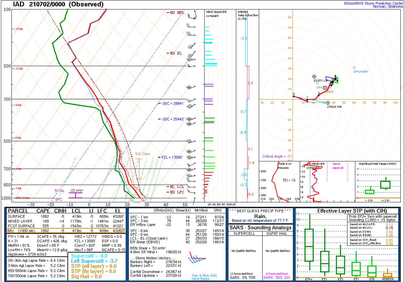
Now while most of the time MLCAPE is more representative of the instability in the atmosphere for storms SBCAPE from the 00z IAD sounding yesterday evening was fairly high 1500-2000J/kg (I'm guessing from limited solar radiation through the afternoon following the earlier storms heating up and evaporating water from the surface leading to higher dewpoints near the surface?) compared to MLCAPE. Now I don't know too much about how storms interact with MLCAPE vs. SBCAPE. I'm wondering if the relative high SBCAPE was a big factor to the intensity of the post-dusk intensity of the storms... especially when combined with relatively fast flow aloft in the mid-levels of the atmosphere as seen below. I too would love to learn about that. Perhaps @high risk @csnavywx know more about storm behavior wrt ML and SB cape?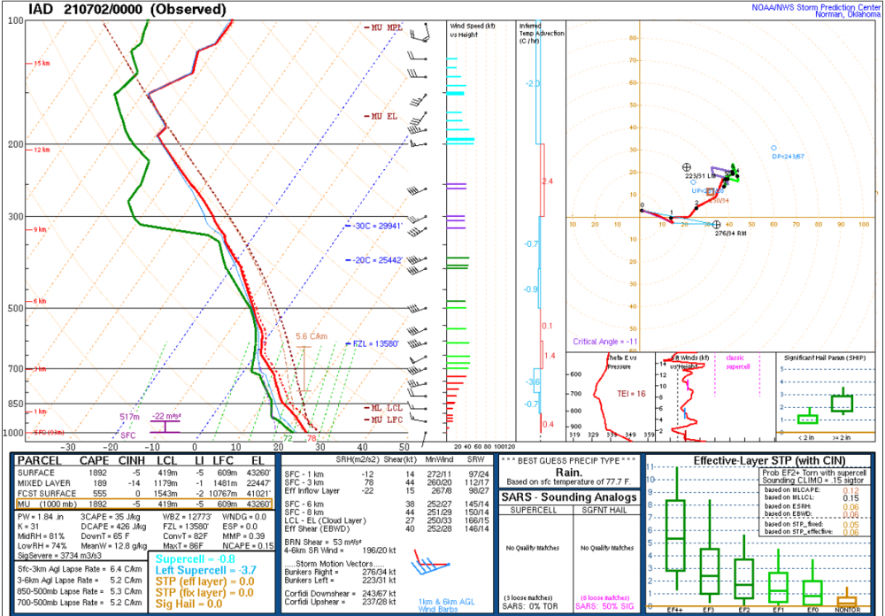
-
2021 Mid-Atlantic Severe Weather - General Discussion
George BM replied to Kmlwx's topic in Mid Atlantic
I had noticed early this evening (6-8pm) that the dewpoint temps had risen to the low/mid 70's yielding 1500+ J/kg SBCAPE. Okay, I thought, that little bit of convection in the mountains may intensify into heavy downpours w/ occasional lightning and gusty(non-severe) winds given the 40kt EBWD. But legitimately severe winds with a potential tornado? Nope I certainly didn't anticipate the convection getting THIS intense. -
How much did you find in the gauge after getting home yesterday?
-
But not when I'm running.
-
Soon... NWS George BM Headquarters July 4 2021 250PM EDT Severe Thunderstorm Watch in effect until 10pm edt *Particularly Dangerous Situation* Hazards: Widespread damaging winds and scattered significant gusts to 105mph expected A few tornadoes possible Scattered large hail events w/ isolated very large hail events to 3 inches in diameter possible Discussion: Storms starting to develop over southewestern PA and southeastern OH will quickly organize into an intense MCS an accelerate southeastwards through the watch area. With extreme to excessive instability, record high Pwats and large DCAPE downbursts and microbursts within the line will be able to bring down high-end severe, hurricane-force wind gusts. Any supercells that manage to form ahead of the main line given the 35-45+kt effective bulk shear and 150-200m2/s2 will be capable of producing all hazards (tornadoes/wind/hail) with the potential for very large hail to perhaps giant hail. Stormtops: 700 Mean storm motion vector: 31055