George BM
-
Posts
2,835 -
Joined
-
Last visited
Content Type
Profiles
Blogs
Forums
American Weather
Media Demo
Store
Gallery
Everything posted by George BM
-
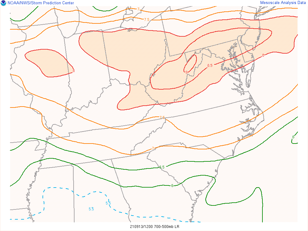
MLLRs are just a WEE bit on the steep side this morning. Now if it were two months earlier with a stronger sun-angle resulting in steeper LLLRs w/ sufficient lower-level moisture and there was a thunderstorm complex dropping southeast into the region, especially during a favorable time of day, then.....
-
Yeap. It shows the first digital <=540 dm 1000-500mb thickness values over the region since spring. #Soon
-
Is it meteorological or climatological? It's here... Fall... we'll get a taste post-Ida.
-
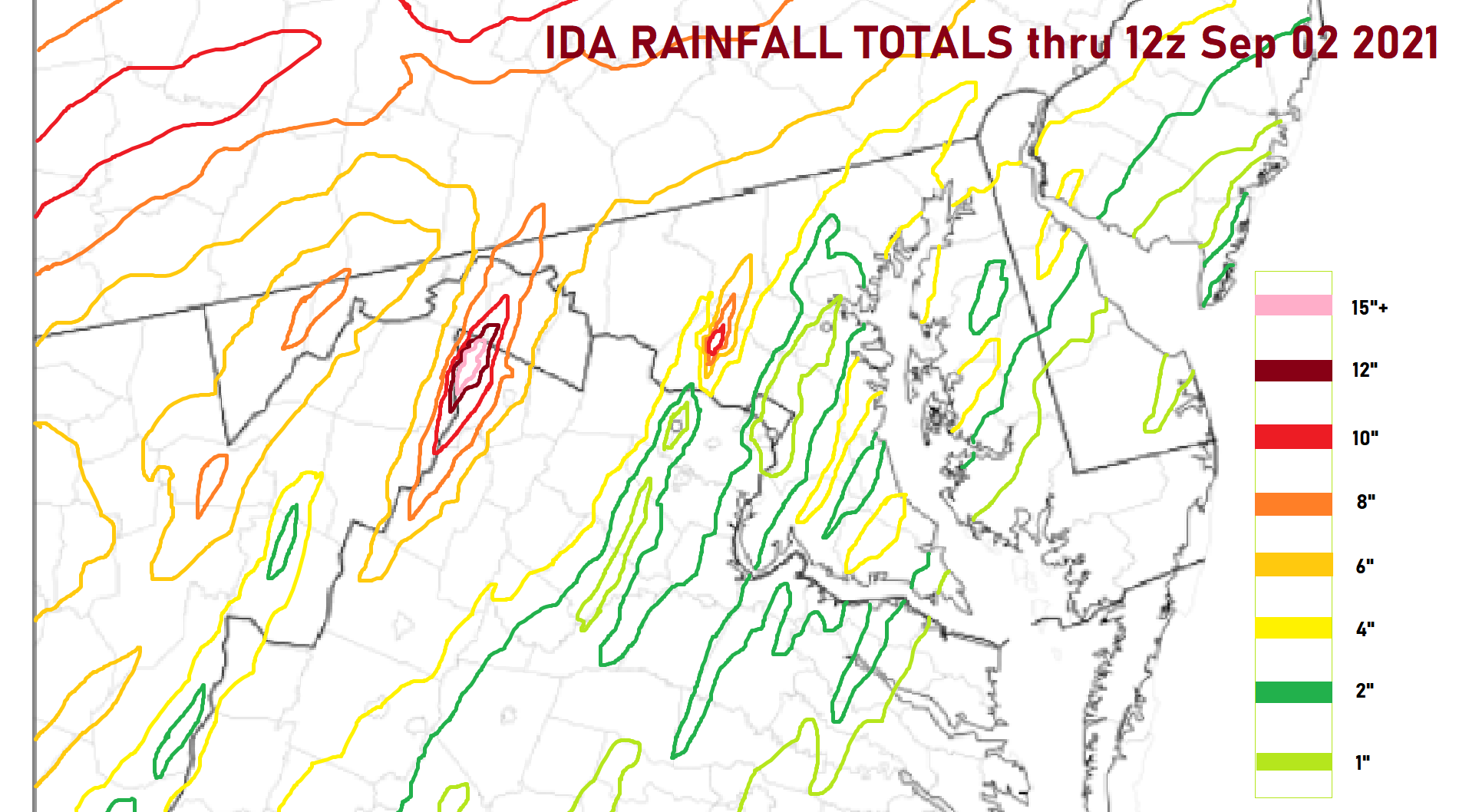
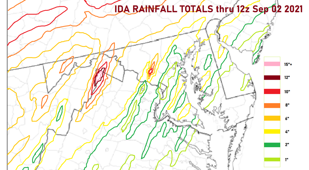
Woah! Just came back from the future with this rainfall map. Check out those two jackpot zones.
-
2021 Atlantic Hurricane Season Tracking Thread
George BM replied to WxWatcher007's topic in Mid Atlantic
718 WTNT31 KNHC 300240 TCPAT1 BULLETIN Post-Tropical Cyclone Julian Advisory Number 5 NWS National Hurricane Center Miami FL AL112021 300 AM GMT Mon Aug 30 2021 ...JULIAN BECOMES AN EXTRATROPICAL CYCLONE... ...THIS IS THE LAST ADVISORY... SUMMARY OF 300 AM GMT...0300 UTC...INFORMATION ---------------------------------------------- LOCATION...38.1N 41.9W ABOUT 820 MI...1325 KM SE OF CAPE RACE NEWFOUNDLAND ABOUT 810 MI...1300 KM W OF THE AZORES MAXIMUM SUSTAINED WINDS...60 MPH...95 KM/H PRESENT MOVEMENT...NE OR 40 DEGREES AT 26 MPH...43 KM/H MINIMUM CENTRAL PRESSURE...995 MB...29.39 INCHES -
2021 Atlantic Hurricane Season Tracking Thread
George BM replied to WxWatcher007's topic in Mid Atlantic
How do our 3" probabilities look? -
Yeah. I saw the big storms blow up right over your house from colliding boundaries and even considered asking you for a report. (Curious George.)
-
2021 Atlantic Hurricane Season Tracking Thread
George BM replied to WxWatcher007's topic in Mid Atlantic
000 WTNT34 KNHC 261445 TCPAT4 BULLETIN Tropical Depression Nine Advisory Number 1 NWS National Hurricane Center Miami FL AL092021 1100 AM EDT Thu Aug 26 2021 ...TROPICAL DEPRESSION FORMS OVER THE WEST-CENTRAL CARIBBEAN SEA... ...TROPICAL STORM WARNINGS ISSUED FOR THE CAYMAN ISLANDS AND PORTIONS OF WESTERN CUBA... SUMMARY OF 1100 AM EDT...1500 UTC...INFORMATION ----------------------------------------------- LOCATION...16.9N 79.2W ABOUT 115 MI...180 KM SSW OF NEGRIL JAMAICA ABOUT 210 MI...340 KM SE OF GRAND CAYMAN MAXIMUM SUSTAINED WINDS...35 MPH...55 KM/H PRESENT MOVEMENT...NW OR 325 DEGREES AT 13 MPH...20 KM/H MINIMUM CENTRAL PRESSURE...1005 MB...29.68 INCHES -
Yeah. I'm in the Dulles area. I can confirm. For the past month I've watched storms and microbursts move around me the "highlight" being a microburst that hit Sterling a few miles to my north followed by the one that hit Franklin Farm, Reston, Vienna, etc. A couple miles to my south and southeast on August 13th. Believe it or not I haven't mowed the grass since Saturday, July 17th (over 5 weeks). The recent rains have finally allowed the grass to grow enough that I will mow it tomorrow.
-
2021 Mid-Atlantic Severe Weather - General Discussion
George BM replied to Kmlwx's topic in Mid Atlantic
Wait... Hail? -
Nice catch. I guess "bay-enhanced" may've been a better term.
-
Looking like some bay-effect downpours are occurring over the Chesapeake this morning.
-
2021 Atlantic Hurricane Season Tracking Thread
George BM replied to WxWatcher007's topic in Mid Atlantic
Thank you Showmethetropical! -
Less than 1/2" here. Herndon, VA. 0.48" at IAD.
-
Summer 2021 maximum temperature forecast contest _ results posted
George BM replied to Roger Smith's topic in Mid Atlantic
I wonder if it has to do with how dry IAD has been lately compared to other locations. Throughout this weeks heatwave I noticed that cumulus would always first develop around IAD. Perhaps with how dry it is in that area the ground heats up quicker and we hit the convective temperature before surrounding areas? I noticed the same thing yesterday after the morning mid-level clouds dissipated/moved east. It's what lead to the development of the eastern Loudoun, Montgomery, northern Fairfax county storms. Just a little something I've noticed all week. -
IAD has hit 100F.
-
IAD hitting 99F thus far.
-
Now IAD has hit 98F so far.
-
I've just noticed how smoke/haze free the skies are today. There'd been a hint of haze for weeks. Nice sunset coming.
-
Hopefully a month where at the end we can get together and say "This was an eventful weather month. Long overdue."
-
August. Have fun. Avoid cheep beer and fly into the eyewall of a major cane off the coast in your Weenie-O aircraft... ... I got nothing.
-
2021 Mid-Atlantic Severe Weather - General Discussion
George BM replied to Kmlwx's topic in Mid Atlantic
I have little doubt that tornado tracks will ultimately be confirmed near Fredericksburg and in northern Maryland. -
I got a taste of @EastCoast NPZ's magic this week. Other than a couple big drops of rain Monday and a brief light/moderate shower yesterday afternoon with the cell that fizzled over me ( maybe ~0.05" total?) it was a shutout for me here in Herndon. Positive Spining Time : Less mowing. My grass has barely grown since last mowing it two Saturdays ago.
-
2021 Mid-Atlantic Severe Weather - General Discussion
George BM replied to Kmlwx's topic in Mid Atlantic
PDS STW or bust! My two amateur pennies: With a WNW to ESE boundary nearby (just to our northeast) tomorrow a few storms could pop. While shear looks fairly modest, low-level lapse rates look to be very steep with mid-level lapse rates around 6+C/km. Any storms that do pop will have a good environment for downburst winds. A potential limiting factor would be slightly lower low-level moisture content (PW 1.25"+, MeanW: 10g/kg or so). But slightly cooler mid-level temps may offset that a bit. Thursday is more dependent on what happens upstream late Wednesday/early Thursday. But flow/shear look to be stronger at least. -
Western Fairfax county peeps represent!