

George BM
-
Posts
3,055 -
Joined
-
Last visited
Content Type
Profiles
Blogs
Forums
American Weather
Media Demo
Store
Gallery
Everything posted by George BM
-
Hey! I've been rooting for you and everyone that's missed out on our big weather events to get to see something special in return. At least you finally got that microburst last August as kind of a make-up. As for me I'd rather not talk about how that end of July to mid-August pulse severe period last summer here in Herndon.
-
@mappy I hope today has been a great birthday for you.
-
2022 Atlantic Hurricane Season Tracking Thread
George BM replied to WxWatcher007's topic in Mid Atlantic
The Atlantic looks very unJune-like with all of the convection and AOIs in multiple locations (two in the MDR). The only sign that it's still very early in the season is the fact that all of the convection in the MDR is at or below 10N in latitude owing to the ITCZ still being well south of 10N. -
@NorthArlington101 I remember waking up early that morning as the first cluster of storms raced southeastwards across the NE MD, NJ, Philly region. The temperature raced up into the upper 90s w/ dewpts into the 70s by late in the 10am hour. It was the hottest that I could recall feeling outside at that time of the day. In fact that whole day in general was probably the hottest I'd experienced in my life even through today (6/24/2022). By midday the storms that I'd been watching thorough the morning were closing in on Chicago with the line of storms slowly starting to become oriented more perpendicular to the flow (from W-E to more NNW-SSE). Being someone who's always hoping for a big storm I watched them hoping that they would be able to survive the trek over Lake Michigan and start taking advantage of the unusually hot/humid airmass in their path. Once they hit Fort Wayne, IN with a 91mph wind gust and a STWarning was issued w/ storm motion of 80mph I knew that the storms were officially tapping into the highly unstable airmass. My only gripe was that based on the speed and trajectory of the storms they would reach my house in Herndon, VA after sunset. But I still watched them with anticipation as they cruised through Ohio and sprinted into West Virginia. By 6:40pm that evening we were placed under a Severe Thunderstorm Watch only making my anticipation grow. Okay enough rambling let's get to the storm... By 10pm that evening I was listening to WTOP radio talking about a 61mph wind gust in Winchester, VA from the storms. I was outside looking at the occasional lighting in the western sky. Nothing too crazy though. By then a STWarning for quarter size hail and 80mph wind gusts was in place for my area. One interesting aspect of this storm that I remember was that roughly two minutes before the gust front hit an unusually steady westerly wind (no gusts just wind) started to slowly increase until it hit maybe 25mph. During that roughly two-minute period I listened to the familiar crescendo of distance tree leaves rustling in an incoming gust front. Obviously, the gust front eventually hit and when it did the trees started moving in ways that I'd never seen them move before. They were bending like flexible dancers and my eyes were getting covered in dust. About ninety seconds to two minutes into the, probably, 50 to 60 mph wind gusts the power went out and I went inside. The winds remained very strong blowing sheets of rain across the road which I could, surprisingly, see especially when the lightning flashed. Now about the lightning. Remember when I said earlier that it was nothing too crazy in the western sky prior to the storm hitting? Well during the storm the lightning flash frequency increased until it was almost a strobe. Despite that though, and this is another weird aspect that I noticed about the storms, there was only one really audible crack of thunder that occurred two seconds after a flash of lightning. I also remember experiencing a rear-inflow jet for the first time as the winds remained elevated for several minutes after the heavy rain ended with 30 to 40 mph northwesterly gusts common. The next morning the first thing that I noticed was how refreshing it felt despite the forecasted temperatures and humidity being identical to the previous day. I walked around the neighborhood and found two trees that had been toppled over and one tree that was spilt down the middle. Though overall, my area got off easy compared to a lot of other neighborhoods around the DMV. I even got power back by 10:30am that morning while some spots were without power for one to even as much as two weeks. I consider it the strongest thunderstorm that I've personally experienced in my lifetime.
-
2022 Mid-Atlantic Severe Wx Thread (General Discussion Etc)
George BM replied to Kmlwx's topic in Mid Atlantic
Warrenton especially the west side is getting raked. Lots of 90+mph pixels on the west side of town. -
2022 Mid-Atlantic Severe Wx Thread (General Discussion Etc)
George BM replied to Kmlwx's topic in Mid Atlantic
Now a few 91.7mph pixels. -
2022 Mid-Atlantic Severe Wx Thread (General Discussion Etc)
George BM replied to Kmlwx's topic in Mid Atlantic
Seeing some 80-86mph winds on velocity scans with this one. -
2022 Mid-Atlantic Severe Wx Thread (General Discussion Etc)
George BM replied to Kmlwx's topic in Mid Atlantic
That's an error. -
2022 Mid-Atlantic Severe Wx Thread (General Discussion Etc)
George BM replied to Kmlwx's topic in Mid Atlantic
87/67 at IAD currently. -
2022 Mid-Atlantic Severe Wx Thread (General Discussion Etc)
George BM replied to Kmlwx's topic in Mid Atlantic
I could use an MCS. -
48F for the low at IAD tying the daily record set in 2000.
-
Happy Fathers Day and Happy Juneteenth to all!
-
I'm loving all of the old vintage planes taking off from Dulles International airport using Runway 01R. I've seen a couple DC3s and a fighter jet (probably an F-15,16 or 18) as well.
-
96/66 at IAD 2:15pm.
-
95/68 at IAD 12:59pm.
-
93/73 at IAD currently.
-
2022 Mid-Atlantic Severe Wx Thread (General Discussion Etc)
George BM replied to Kmlwx's topic in Mid Atlantic
Just noticed that from radarscope wondering whether it was a glitch. So you heard thunder from them? -
ROS. Ring of Smoke pattern. (Smoke aloft being carried around the ridge) A 'dull red circle' sunset inbound.
-
2022 Mid-Atlantic Severe Wx Thread (General Discussion Etc)
George BM replied to Kmlwx's topic in Mid Atlantic
My two amateur cents about this 'event': To @high risks point the HRRR was doing a very bad job with the handling and even initialization of the Chicago-Ohio MCS. @Kmlwx with great similar points about it. By mid-evening it was apparent that the HRRR was significantly underdoing the Chicago-Ohio MCS which would, obviously, in turn result in a less organized MCS following it from northern MI (the one the HRRR kept keying on to hit our region). Something else that I'll like to point out that I noticed were the storms that formed early in the afternoon yesterday in Indiana. No, not the one that brought a 98mph wind gust to Fort Wayne, IN, but the storms that grew upscale into an MCS that moved ESE through WV and into the central Appalachians by midnight (same activity that got @wxdude64 some late evening action). What that MCS created was a region of limited/no instability, especially in WV. In the time-sensitive loop below you can see how the MCS that hit Chicago and Fort Wayne splits into two separate convective line segments as it hits this 'used up' atmosphere with the SW segment going SSE through western WV and into far southwestern VA and the NE segment moving east into northern/central MD and southern PA. https://weather.cod.edu/satrad/?parms=regional-eastcoast-comp_radar-200-1-25-1&checked=map&colorbar=undefined The Cincinnati to WV MCS also left an MCV which may have tugged the OH MCV a little further south further limiting the impressive NW mid-level winds over us and shifting it southwest although I admittedly know far to little about this to say this is occurred for sure. In my opinion these things are what left most of VA without any real convection this morning. Of course, there are probably other more subtle features that affected things but those are the main ones I caught with my limited knowledge compared to actual meteorologists. -
2022 Mid-Atlantic Severe Wx Thread (General Discussion Etc)
George BM replied to Kmlwx's topic in Mid Atlantic
Completely unrelated to any thoughts about tonight/tomorrow... today marks nine years since the last time the immediate area was under a MOD risk of severe weather from the SPC. -
2022 Mid-Atlantic Severe Wx Thread (General Discussion Etc)
George BM replied to Kmlwx's topic in Mid Atlantic
Yeap. I remember the June 3, 2020 derecho to our north producing hurricane-force wind gusts despite only weak to modest CAPE available and early time of day owing to the MCSs cold pool/ rear-inflow jet. Granted there were a couple hours of solar heating before the storms got to New Jersey where the most extreme damage occurred. But it was still solidly before peak heating with relatively modest LLLRs. Not that I expect that here, of course. Just pointing that out. -
2022 Mid-Atlantic Severe Wx Thread (General Discussion Etc)
George BM replied to Kmlwx's topic in Mid Atlantic
Day 2 SLGT 2/15/15 Exerpt for MidAtl... ... At this time, one area of potentially greater storm coverage -- and thus severe potential, given the favorably strong wind field forecast atop the region -- will be along and east of the higher terrain of the central Appalachians. Storms should develop by early afternoon, and spread east-southeastward with time. Organized/rotating updrafts should evolve, given the available shear, with these stronger storms capable of producing large hail and damaging winds. Risk may continue well into the evening across portions of the area, as one of the more pronounced disturbances aloft shifts southeastward out of the Midwest and across the mountains during the evening/overnight. -
2022 Mid-Atlantic Severe Wx Thread (General Discussion Etc)
George BM replied to Kmlwx's topic in Mid Atlantic
Just for laughs. Lol NAM. Sounding from the 6z NAM for Warrenton at 2pm Tuesday. Just a small hunch but I feel like the NAM may be overdoing CAPE here just a little bit.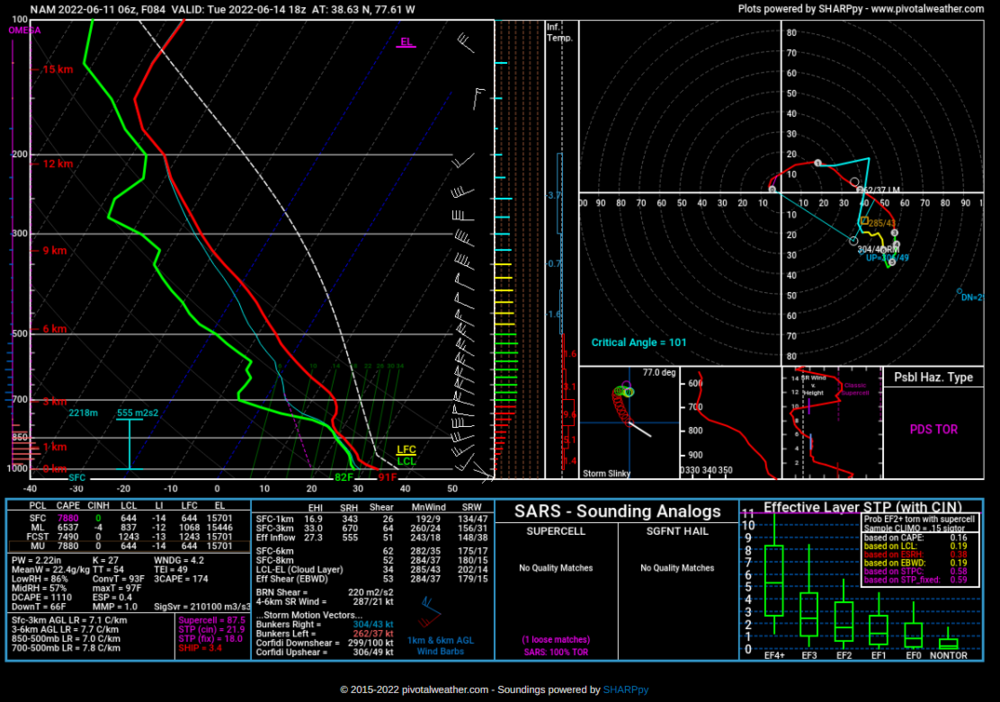
-
2022 Mid-Atlantic Severe Wx Thread (General Discussion Etc)
George BM replied to Kmlwx's topic in Mid Atlantic
Yeah. Some CAMs such as the 18z HRRR is starting to hint at moderate instability and deep-layer shear in place by Sunday afternoon. Would be nice to get some action in these parts on Sunday before our early/mid week derechos.


