George BM
-
Posts
2,835 -
Joined
-
Last visited
Content Type
Profiles
Blogs
Forums
American Weather
Media Demo
Store
Gallery
Everything posted by George BM
-
2022 Mid-Atlantic Severe Wx Thread (General Discussion Etc)
George BM replied to Kmlwx's topic in Mid Atlantic
Are you talking about the winds with the pre-frontal gradient tomorrow night/pre-dawn Friday or are you talking about the winds w/ the post-frontal surge? Or is the answer to this question just, "Yes". -
Mid-Atlantic forum winter 2021/22 snow totals thread
George BM replied to North Balti Zen's topic in Mid Atlantic
Herndon, VA 11/30/2021: T 1/03/2022: 6.0" 1/07/2022: 4.8" 1/16-17/2022: 2.8" 1/20/2022: T 1/28/2022: 0.8" 2/13/2022: 1.4" ... Total as of February 15, 2022: 15.8" -
2022 Mid-Atlantic Severe Wx Thread (General Discussion Etc)
George BM replied to Kmlwx's topic in Mid Atlantic
My two (non-expert) cents: For Thursday night/early Friday the main threat would be gusty winds from a thin line of heavy rain along the cold front. As it looks right now, the trough seems too positively tilted for anything too significant especially given the (at most) maybe 200J/kg CAPE. It's the strong winds aloft with these off season systems which the heavy rains can bring down to the surface. The cold front and the flow don't look too far from parallel though (cold front orientated from 7:30-1:30 w/ mean flow from 8-2), less than 30 degrees. This limits the wind potential with convection. With the February 7th, 2020 event that brought 50-60+mph wind gusts and tornadoes especially in northern MD, the trough was negatively tilted with the mean flow and the cold front more perpendicular (line of low-topped storms extending from NNW to SSE w/ mean flow from the SW). That combined with a strong sub-980mb low moving along the Blue Ridge mountains helped back surface winds to the southeast creating high low-level shear which lead to lots of bowing segments along that line with tornadoes forming along the kinks of said line. An event like that is probably the only way to get more widespread severe in these parts this time of the year (not that you or anyone here implied there could be widespread severe later this week. ). -
Feb 12/13 Event Quest for Blues to Envelop More Rather Than Less
George BM replied to North Balti Zen's topic in Mid Atlantic
I'm wishing that this disturbance moved across the region during the daytime. Daytime heating, though heating the surface and leading to snow melt, would allow for more numerous and intense snow showers/squalls popping up distributed more evenly across the region. It could certainly still be fun for some late overnight/pre-dawn. -
Feb 12/13 Event Quest for Blues to Envelop More Rather Than Less
George BM replied to North Balti Zen's topic in Mid Atlantic
Time sensitive but very cool radar loop of a meso-low over Cleveland Ohio... https://weather.cod.edu/satrad/nexrad/?parms=CLE-N0Q-1-96-25-usa-rad This is part of the energy that will swing through late tonight. -
63 currently at IAD after a low of 23.
-
Looks like we may actually see widespread low 60's or so for highs today.
-
https://www.weather.gov/wrh/climate This is a good place... at least for our local airports. I'm not sure how other forecast offices display their climate data. Just click on the forecasting area you want and that should lead you to a lot more climate data is they have it.
-
The 6z 3km NAM shows light ZR/possible needles over much of the area tomorrow morning through midday/early afternoon hours. Just something to watch... ...I'm also aware of how well it did with temps for Wednesday of this past week. But still... something to watch assuming precip makes it far enough NW.
-
Looking at this picture I get the feeling that a large 60-foot tall lanky creature/monstrosity is about to emerge from the fog. ETA: 50/48 at IAD. Light misty rain/drizzle.
-
"Command" ahahaha. Command... *sigh*
-
Non-expert thought: I wonder whether this has to do with how the NAM is handling the interaction between the snowpack over the Delmarva and the near surface air and how it's handling the albedo effect. Skew-t's on the 3km NAM suggest that low clouds move in from the east overnight/pre-dawn tomorrow morning and hang around all day while none of the other models do this.
-
We've reached the point where mornings are starting to brighten earlier. 25/14 at IAD.
-
Mid-Atlantic forum winter 2021/22 snow totals thread
George BM replied to North Balti Zen's topic in Mid Atlantic
Herndon, VA 11/30/2021: T 1/03/2022: 6.0" 1/07/2022: 4.8" 1/16-17/2022: 2.8" 1/20/2022: T 1/28/2022: 0.8" ... Total as of January 30, 2022: 14.4" -
January 28-29 2022 Miller abcdefu Storm Obs/Discussion
George BM replied to mappy's topic in Mid Atlantic
Good morning weather weenies! I'm pretty happy about all the great reports and pics coming in from up north. Hopefully this band can develop into a surprise 6"+/hr thundersnow band that buries all of us and our worries under 2-3'+ of snow! Now you all know what to do. WEENIE ME UP! ... 33/17 at IAD under mainly cloudy skies at IAD atm. -
January 28-29 2022 Miller abcdefu Storm Obs/Discussion
George BM replied to mappy's topic in Mid Atlantic
31/18 under overcast skies at IAD. -
@DDweatherman
-
Morning lows: IAD: 12F (coldest of the season) DCA: at least 17F(have to see intrahour) BWI: at least 15F(have to see intrahour)
-
I like the snow squall that the 3kNAM is selling.
-
Appetizer thread--to track the sunday clipper and the tuesday slopsh%T
George BM replied to Ji's topic in Mid Atlantic
The 3km NAM shows a nice snow squall moving through from NW to SE. Soundings show steepening low-level lapse rates as the disturbance moves through the region leading to some 0-50j/kg MUCAPE (generally below 700mb) on this model.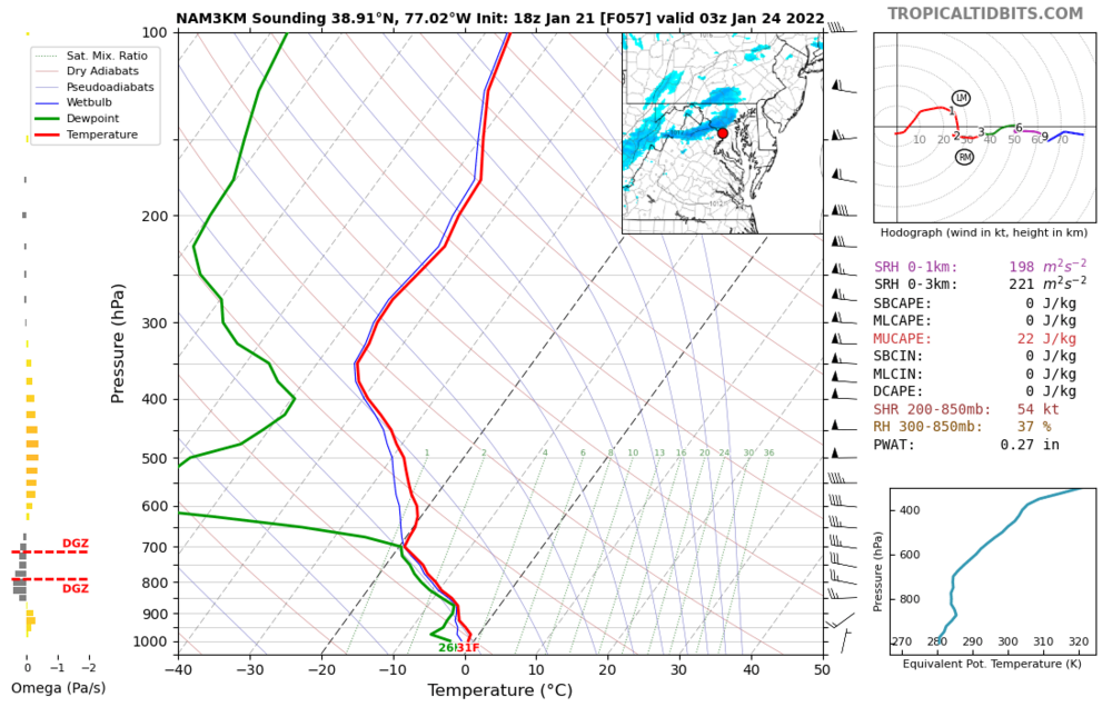
-
*Adds "Apocalyptic Frost Quake" to a certain list.* 17/1 at IAD this morning. DCA into the teens again (down to at least 19F).
-
Thursday 1/20/22 Stat Padder Discussion and Observations
George BM replied to stormtracker's topic in Mid Atlantic
What direction does your back and front yard face? -
Thursday 1/20/22 Stat Padder Discussion and Observations
George BM replied to stormtracker's topic in Mid Atlantic
URGENT - WINTER WEATHER MESSAGE National Weather Service Baltimore MD/Washington DC 109 PM EST Wed Jan 19 2022 DCZ001-MDZ011-013-014-016-504-506-508-VAZ052>056-502-200215- /O.NEW.KLWX.WW.Y.0008.220120T1100Z-220120T1800Z/ District of Columbia-Southern Baltimore-Prince Georges- Anne Arundel-Charles-Central and Southeast Montgomery- Central and Southeast Howard-Southeast Harford- Prince William/Manassas/Manassas Park-Fairfax- Arlington/Falls Church/Alexandria-Stafford-Spotsylvania- Southern Fauquier- 109 PM EST Wed Jan 19 2022 ...WINTER WEATHER ADVISORY IN EFFECT FROM 6 AM TO 1 PM EST THURSDAY... * WHAT...Snow. Snow accumulations of up to two inches with locally higher amounts around three inches possible. * WHERE...The District of Columbia, portions of central, northern and southern Maryland, and central and northern Virginia. * WHEN...From 6 AM to 1 PM EST Thursday. * IMPACTS...Plan on slippery road conditions. The hazardous conditions will impact the morning commute. * ADDITIONAL DETAILS...Precipitation will start as rain and then switch over to snow during the Thursday morning commute. PRECAUTIONARY/PREPAREDNESS ACTIONS... Slow down and use caution while traveling. When venturing outside, watch your first few steps taken on steps, sidewalks, and driveways, which could be icy and slippery, increasing your risk of a fall and injury. && $$