
PowderBeard
-
Posts
2,002 -
Joined
-
Last visited
Content Type
Profiles
Blogs
Forums
American Weather
Media Demo
Store
Gallery
Posts posted by PowderBeard
-
-
5 minutes ago, Typhoon Tip said:
It's the girl of my dreams standing before me with a subtle indentation of her va-goo-goods visible through her fashionable skin-tight yoga wear -
1 minute ago, Chrisrotary12 said:WTF just happened?

-
 1
1
-
-
1 minute ago, CoastalWx said:
It was about to go off too. If you look at 700 and 500, it really can't get much further north than that. Probably would move ENE out under LI and it intensifies.
Thanks for the lesson, I see what you mean.
-
Take it for what it's worth (la la land), but the NAM puts the system into the Ohio River Valley vs. running further SE. Wouldn't be surprised if 0z took the low right over SNE.
edit: Doesn't look nearly as cold compared to the Ukie or GFS.
-
9 minutes ago, Baroclinic Zone said:
Damn the Ukie is frigid.
Hopefully overdone. That and a couple inches of snow on heavy trees = cold house combination.
-
5 minutes ago, moneypitmike said:
So---is anyone going to say the ground won't allow for accumulating snow in October?
SUN ANGLE!
-
1
-
-
14 minutes ago, dendrite said:
I’ll keep wearing my P95. It at least keeps me from having to smell other people’s bad breath and body odor.
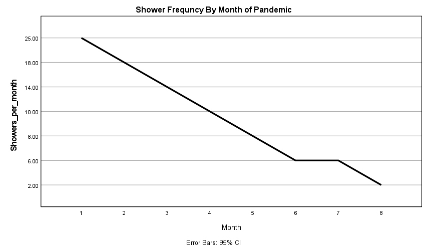
Yea, not a good trend there. This is data from people working from home. Cooler weather here will mean less bathing, we are in for a long winter.
-
 2
2
-
2
-
-
12 minutes ago, HoarfrostHubb said:
My son’s University in RI has been very successful so far in keeping the virus out. Since late August only 0.01% (Yup) positive tests. Testing all on campus twice a week. Contact tracing positives.
They had one small cluster but quickly isolated that.I'm assuming this is a school other than URI? I went there and am friends on FB with a few profs and their numbers are much higher. The first few weeks of October the off campus student positivity rate was close to 4% and Greek housing students were testing positive at over 11% (which required a 14 day shelter in place for all students in "Greek" housing). That said, their on campus student positivity rate was fluctuating between 0.40-0.70% which is great.
-
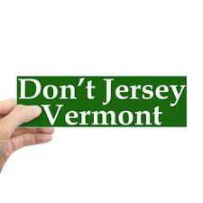
10 minutes ago, radarman said:
VT peeps high fiving eachother over travel bans
"they still think this is about the covid LOL"
-
The seal is a really easy process that gets a bad rap around here. Once out there I really understood it. Don't want to see the place get trashed with invasive species like so many other lakes in CT/MA/RI. There is little/no vegetation in the place, fish and wildlife are fat and healthy, just prime. Bring it to a car wash up in Athol (they have 2 wash days per month) and they have a decon process. Then it is wired to your trailer any time you are not in the Quabbin. If you want to put it in another lake you have to cut the wire, go where ever, then have it decontaminated all again.
It's like a $40 season pass in my book. As close to being in the wilderness in Mass as you can come, bears and cubs walking the shore, deer and moose swimming across it, loons everywhere, bald eagles dive bombing the water for trout. Feels like a lake in the middle of Maine most times and you might see 2-3 other boats all day during the week.
-
4
-
-
Feels like downeast Maine here today. 60 with showers/mist and a good breeze.
-
1
-
-
-
42 minutes ago, Ginx snewx said:
Gorgeous. Only shore fishing? Massachusetts lol
I ran the Quabbin "Day Care Center" all summer. She really loved the loon calls. We were probably out there 3-4 days per week. If we went more than a couple days without going out she would sit at the back slider looking at the boat yelling "fiiisshhhh." Would wake up around 4/4:30, get all my work done, head out around 10am, pack a ton of food and she would nap in a tent on the boat. Great summer out there.


-
3
-
-
21 minutes ago, Ginx snewx said:
I am loving this. Got some fishing in yesterday. Today looks cloudy but mild
Clouds just make fish more curious and stupid lol
-
1
-
-
21 minutes ago, dendrite said:
Lots of TS obs with mixed precip up in Minny this morning.
KMSP 221453Z 03010KT 5SM VCTS -SN BKN046 OVC060CB 01/M02 A3015 RMK AO2 LTG DSNT
 E AND W SLP219 RAE11PLB07E49SNB11E34B43 VCTS W MOV NE P0003 60003 T00111017
 55007=
Was surprised to see some videos of this on FB. Have a few friends out there doing post-docs.
-
1
-
-
42 minutes ago, bwt3650 said:
I think just locking them by straight up county would be easy for them, but I don’t see how they handle the quarantine aspect of it. And to just flat out lock out counties I think presents a legal argument...Vermont currently is not preventing interstate travel, they are just setting guidelines on how to do it...just my opinion, but I certainly believe you that it was/is being discussed.
I would agree get Snowdon first then you have the six pack and triple going at the same time to help with lift lines due to the restrictions..maybe they work on skye peak or bear earlier than usual to spread people out to that base area? I’m not that familiar with their usual opening besides the ridge then snowdon.
Yes and I also wonder about the legal troubles for ski areas since they have the info available (e.g., RFID, driver's licenses, pass mailing locations, credit card zip codes). If there is an outbreak that is traced to their mountain from those "red" individuals I could see an easy lawsuit there (profits > lives!). I'm not sure if there is a legal problem with refusing based on county due to the travel restrictions (I'm sure someone will try to make a discrimination case from it). It reminds me of how NH gun stores will refuse to sell ammo to Mass and CT residents because they have that info available to them via driver's licenses and credit card zip code/billing info.
In terms of opening Bear is a great idea to spread things out. I imagine they are in no rush to open K1 given the confined space and decreased area capacity. Maybe Snowdon to Canyon and Ridge area via Kilink and East Fall. Then Skye Peak to Bear via Skyeburst/Gateway/Stash. Finally work on Rams/Snowshed (unless lodging is pre-packed for the late December holiday week).
-
14 minutes ago, bwt3650 said:
But how would they be able to turn people away that are from a red county, but who actually did the quarantine, or who have moved to vt. for several weeks at a time, which I think may be a reality with so many working from home? I assume they would use the address where passes were mailed or registered to? I think they are really pushing the boundary legally if they start that.
Yea I really don't have a clue. Someone on a forum mentioned it a few weeks ago and I thought it was BS. Mike S mentioned on the K-Zone forums they could and were not but clearly they are getting the info somehow. Maybe trying something before ski season?
Side note, since they are going straight to T2B skiing, I wonder about their opening plan. Maybe get Snowdon lifts and Superstar Quad areas blown in and forget the Ridge? I would take that plan over the Ridge to Great Northern any year.
-
Interesting to hear some rumblings of Killington using RFID to track the counties where folks are coming from. Friend went mountain biking at Killington a couple weeks ago and they mentioned it. Second time I have heard this. Be curious if this practice keeps up for winter and if they are actually turning people away.
-
7 minutes ago, HoarfrostHubb said:
We got a mailing from Smugg's the other day. How can a Mass resident even stay there and follow the rules?
My wife and I were just discussing this and I'm looking into it. Reason being, the Indy Pass has some new resorts being added and will be announced tomorrow. I'm sure Bousquet is one given Catamount and Berkshire East are on it. Given the Canadian border is closed and going to hurt some places, I wouldn't be surprised if it was a big VT resort like Jay, Burke, or even Smuggs. Plus Jay apparently sent out an email advertising the Indy Pass a few days ago.
-
1
-
-
This week in 2016 was the best October skiing I have come across. Killington got 5-7" of slop on a Sunday/Monday that froze to make a great base then another 8-10" of heavy wet above 3000' at the end of the week. People were jumping off the stairs to ski Catwalk, ducking ropes off North Ridge to hit the Canyon area and trails off Snowdon. Most of the snow had settled in the East Fall to Royal Flush area and it skied more like 2' .Trails like Downdraft were skiable, just had to be careful around the water bars. Folks must have gotten hurt or patrol got chewed out because a few weeks later they got another 8-10" and the same could have happened but Killington put 3/4 staff members at every rope to keep people on the Ridge. Even keeping people from accessing Ridge Run and Poweline. Needless to say, people were pissed and many bailed after a run or two. My last time at Killington early season unless they actually list stuff as "open".


I hear lots of discussion/rumors of how K used to blow snow on Dipper for early season, that would be an incredible early play and hard to beat...unless (and I'm dreaming) Sugarbush ever could open Heaven's Gate with Ripcord, Organgrinder, Jester, and Downspout then have folks download on Super Bravo.
-
37* and fogged in. Yet to have frost on the lawn.
-
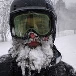
Got pelted with some sleet and had some flakes mixed in driving the boat this morning on the north end of the Quabbin. Quite the painful surprise.
-
1
-
-
Flakes and wintery stuff mixing half way up MRG.
Over 1.5" here.
-
2
-
-
-
0.89" already. Wouldn't be surprised if somewhere west of Worcester in Mass grabbed >3".

Oct 29-30 snow threat
in New England
Posted
Still a decent chance of accumulating snow throughout SNE. No complaints for October.