
PowderBeard
-
Posts
1,965 -
Joined
-
Last visited
Content Type
Profiles
Blogs
Forums
American Weather
Media Demo
Store
Gallery
Posts posted by PowderBeard
-
-
Avalanche warning for Blue Hill.
-
2 minutes ago, ORH_wxman said:
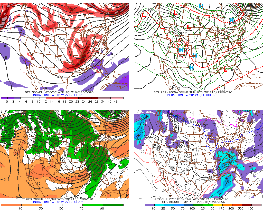
12z Reggie wasn’t on board either.
Kind of skeptical of that threat but who knows. Sometimes a sneaky band on northern edge could produce a couple inches.
Reggie and the NAM are pretty juiced. Close to a good hit for those southern areas.
-
1 minute ago, 40/70 Benchmark said:
Yea, it has the primary making deeper into the OHRV.....which is what some of us have been warning about, and why PA may not get 20"+.
Yup, after your last comment on one of my posts you hinted at that and I noticed right away. Great call.
-
 1
1
-
-
End of that NAM run looks like the makings of a Miller B with a little further north high placement but the hell if I know. How it gets the energy is strange though, more like an A.
-
40 minutes ago, HIPPYVALLEY said:
You have probably met me and taught my kid!
He is a hell of a skier too!
-
 2
2
-
-
3 minutes ago, ineedsnow said:
12z was better
Yea I was comparing the GFS, Euro, UKIE. Should have mentioned that. Not 6-10" in SE areas or a whiff.
-
I'm more curious where is places things at the end of the run.
-
2
-
-
1 minute ago, WinterWolf said:
Ya? Enlighten us a tad?
Similar to the more conservative runs of previous models earlier and not a complete whiff like the EURO and Uncle. Widespread 1-3".
-
 1
1
-
-
NAM is reasonable for Monday.
-
1
-
-
1 minute ago, CoastalWx said:
Euro offshore for monday. Maybe C-1" spots?
Much more believable than the GFS.
-
Euro looked amped going into Monday and a miss.
-
Big dog running now.
-
Just now, RUNNAWAYICEBERG said:
I hope she doesn’t leave if she wins. (that’s what I tell mine).
I don't remember signing a prenup.
-
1
-
-
5 minutes ago, SouthCoastMA said:
Pulling for James here, he needs a biggie. In no way is that a self serving comment. Nope, not at all.
Yea I hope my wife wins Powerball tonight.
-
1
-
-
1 minute ago, HIPPYVALLEY said:
No matter how good models look I will continue to find ways to convince myself that this is going to be congrats Foxboro while I get 3” of baking powder.

The official winter storm song of Greenfield these days?
-
5 minutes ago, 40/70 Benchmark said:
These are the changes that you, scooter and I have been anticipating, and why the 20-30" in PA and NJ is BS. Also why this may be very high impact for some of NE.
Ahhhhhhhhhhhhhhhhhh. Ok. Pretty interesting track if I get what you're thinking.
-
1 minute ago, Whineminster said:
Because we get sad when it's over, so the longer you can extend it the better.
/

-
4
-
-
5 minutes ago, ORH_wxman said:
There’s definitely a limit. The blocking and associated 50/50 low is felt very strongly.
But that main shortwave is going negative fairly far west and it gains some latitude out there too. That’s why I’ve been saying I’d want to be north of Philly...they might be ok there but we’ve seen some runs like the 00z euro which cause ptype issues we’ll into NJ.
Thanks. Makes sense. I think the skepticism is coming from a place of "weenie" and not science because of previous forecast burns (maybe Feb/March 2017?) when we had systems coming in starting with temps in the mid-20s. Crap snow growth for the duration and a few inches of sand when big numbers were forecasted.
-
1
-
-
4 minutes ago, ORH_wxman said:
It can still come further north before turning ENE. Just look at the upper flow around 96 hours. It isn’t exactly suppression city showing up over NNE...you get that vort a little stronger maybe when it assimilates onshore and you could def see a further north solution. It won’t become a cutter or rip inland over ORH because of the block, but there’s some room.
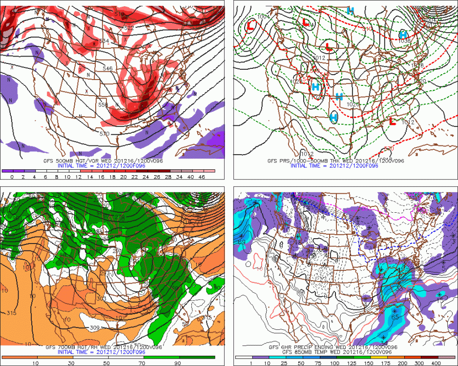
Thanks, the cutter idea is what I meant by "in" but yes north enough to mix/rain along the coastal areas for a time is 100% possible/likely. The suppression idea is locked in my head and keeping me most skeptical but I can see what you mean.
-
5 minutes ago, RUNNAWAYICEBERG said:
lol I don’t think I’ve been negative. Just keeping expectations in check at d4-5. I’ll be all in if we get this inside D2.
Agreed. I still wouldn't be surprised if this thing just ends up grazing CT/RI/SE Mass. It won't come in but could still go out.
-
1
-
-
GFS will put feet in CT this run, tick south.
-
2 minutes ago, dendrite said:
I’m glad we learned a lot from the clown maps a week ago.
So disregard 6-10" of 34-35* power outage paste for RI and SE Mass? lol
-
1
-
-
GFS loving RI and SE Mass on Monday now. Not buying those thermals though. Would have to be a repeat of last week's deal.
-
4 minutes ago, mahk_webstah said:
what is the trend since their last run? will be interesting to see if any trends develop this afternoon, given a pretty consistent look across models so far.
ICON has "inched" it south over the past 3 runs. From taking the low over RI and Boston to 100 miles south of the Cape/islands.
-
1
-
The 2020-2021 Ski season thread
in New England
Posted
Seriously.
Your old hill looked packed today. Lines for Heaven's Gate looked like vacation week. Can't imagine if folks actually head up for vacation week.