
PowderBeard
-
Posts
2,002 -
Joined
-
Last visited
Content Type
Profiles
Blogs
Forums
American Weather
Media Demo
Store
Gallery
Posts posted by PowderBeard
-
-
Mets, read an article today that terrain has no impact on banding because it does not provide enough lift. Is this over simplified or hold true in events such as these?
-
18 minutes ago, weatherwiz said:
H7-H5 fronto starting to strengthen!
I still think the best banding may occur a bit southeast of guidance...at least per mesoanalysis that HP seems farther south

Yea I am thinking that as well but more of a gut thing, not sure why. Think I'm to used to the NW pattern with thunderstorms.
-
 1
1
-
-
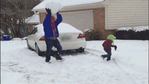
Our kiddo's first real storm being able to run around. I can't wait.
-
4
-
 8
8
-
-
10 minutes ago, Great Snow 1717 said:
I wouldn't be the least bit surprised.
Someone"melting" on 495 after learning Box has downgraded the forecast to 2-4 for the Merrimack Valley area......

Awesome lol. Let the good times roll.
-
2
-
-
21 minutes ago, The 4 Seasons said:
Get in the basement!


-
7
-
-
20 minutes ago, zeepowderhunter said:
Ahhh gotcha!
I have only been able to reap the benefits of volunteer days. They have helped the mountain out a ton. I need to help out sometime. Can’t wait to get up there this season.
This year they really cleaned out the Hollows. Previous years it was creating "Voodoo." Some volunteer days they basically made entire new areas that, luckily, still are not on the map - I believe "Narnia" was a volunteer glade but could be mistaken. Since the east side is one massive glade now the west side needs some love. Only 5/6 real unmarked areas there that are named.
-
Just now, weatherwiz said:
I can't believe 60 units of omega into the DGZ...on both models too. Could see ratios perhaps up around 18:1 if that verifies. Could snow 3''+ per hour for a good 3 hours

Yea I'm really thinking that rt. 8 stretch from Waterbury/Winsted jacks and breaks 20". The Snow Capital of Norfolk could make a run at 2'.
-
HRRR really thumps that Waterbury/Bristol/Torrington, CT area from12-2am. Could see some 3-4" per hour stuff there.
-
 1
1
-
-
4 minutes ago, zeepowderhunter said:
Hmmmm....looks like it might be between Goniff and Red line!
You have been to the volunteer days?
Nice shot!
Hahaha. Not "The G-Spot", the other side of Red. G-Spot has been sneaky good the past couple years, almost like it was forgotten about.
Been to many volunteer days, always a good time.
-
1
-
-
12 minutes ago, MRVexpat said:
Looks tasty. Your handiwork or au naturel?
All natural, just how it grows with that exposure.
My handiwork has not translated well (i.e., narrow chutes down multiple large ice falls that can only be skied a couple days a year). Guess I just don't have the eye for it. The guy behind the camera in these is the master at it. Probably done 10-12 areas at Magic and they are all fun and unique. The lower 200' of one some of use made is pretty sweet though, just gets loaded at the bases of these ledges because of a main trail 100' below it. (I clearly need to stop landing in the backseat)


-
3
-
-
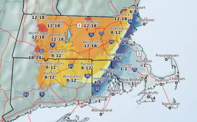
That would be nice. From BOX...
 I`ve stressed higher snow amounts
further to the north and west; after a front-end-thump of heavy snow
overnight, this transitions into a potentially slow-pivoting
snowband affecting the Berkshires, western/central MA into Hartford
and northern Tolland Counties in CT. There is still spatial
uncertainty in where this band may set up, and while amounts here
were raised into the 12-18" range, local amounts in this admittedly
rather broad area could be as much as 20" for those who happen to
remain in this quasi-stationary band.

-
5
-
-
Hoping to try this area for the first time tomorrow, about 600' of nicely spaced and clean woods There is another area close by that is similar but much steeper and would need 10" of cement not blower.

-
1
-
-
6 minutes ago, RUNNAWAYICEBERG said:
But the soil temps..
Oh stop. It's all about sun angle. Especially with these overnight deals.
-
5
-
-
6 minutes ago, ineedsnow said:
Hoping we somehow get into a good band.. curious to see if the 12z models get rid of the snow hole.. I think it has some to do with being between two good bands.
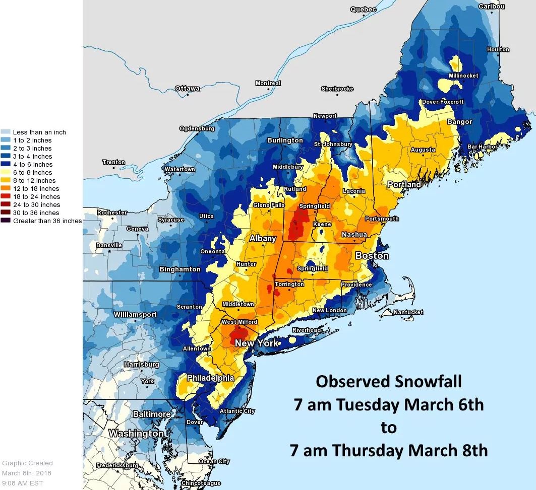
Exactly what happened for this storm March 6-7. Was painful. I think we only had 5-6" in Amherst from this. Just watched the radar get shredded while both east and west were pounding.
-
26 minutes ago, ineedsnow said:
Box going 12 to 18 with amounts up to 20.. guess we wait to see the models today and how things play out but they seem to be going big
Yea I'm excited to see how it pans out. There is some serious micro stuff in this area. As radarman mentioned earlier in this thread, and told me when I moved here, the difference between living off rt. 21 and 202 in Granby can be 8" vs 1" of slush. Same for 202 north of town vs. south. Even when it R/S is not a concern, center of town can get baking powder and 3-4" for the duration of a storm and Swift River area is 8-10". It's fun for sure.
I think BOX is "going big" because of ratios. This should be more of a 12-14:1 storm. Closer to some of those Kuchie maps than the standard 10:1.
-
1
-
-
4 minutes ago, codfishsnowman said:
If taken verbatim 10 to 12 is still a great event, but if it is a 3 to 6 boxing day redux then forget it
Yup, up until yesterday I was still thinking 6-8" and am still doubtful of 10+ here. We have done so well the past few years in terms of snow and severe here we are due for a bust while other areas rake. If things are white and it results in a snowday for my wife I'm happy. The tracking of this event has been fun and quite the learning experience.
-
1
-
-
4 minutes ago, ORH_wxman said:
06z rpm (09z is still running)
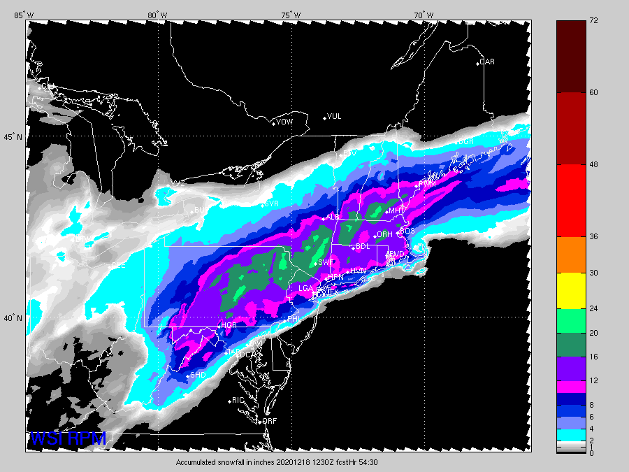
That snowhole over my house is consistent on so many models and was initially showing up 3-4 days ago. Pretty funny stuff.
-
16 minutes ago, Lava Rock said:
7F.
Nice.
Forgot what 13* felt like until I walked outside in shorts, a t-shirt, and boots on this morning to get some firewood.
-
14 minutes ago, powderfreak said:
Gotta use it to figure out what VT ski area gets the most snow. Think you gotta ride with Mt Snow but I was thinking the banding on NAM might have been north of that even.
Definitely. Mohawk/Sundown for the New England jack? lol
-
1
-
-
1 hour ago, MRVexpat said:
Latest guidance has me questioning where to head for some human powered laps Saturday morning...anyone here ever skin Brodie?
Youll get busted for trespassing. Super strict.
-
1
-
-
So many ticks north definitely seeing some dryslot potential in central/western CT up through central Mass. Still lots of time to figure that one out.
-
1
-
 1
1
-
 1
1
-
-
-
Definitely a good step.
-
We should have ratios higher than 10:1, just a matter of what is there for liquid.
Active mid December with multiple event potential
in New England
Posted
Not peer reviewed but appeared to have some sources. I'm not 100% confident in all my terms and lingo to dive into primary sources yet.
http://www.theweatherprediction.com/weatherpapers/023/