

klw
-
Posts
4,757 -
Joined
-
Last visited
Content Type
Profiles
Blogs
Forums
American Weather
Media Demo
Store
Gallery
Everything posted by klw
-
So the range for the potential in my area has been reduced to a dusting to 28 inches. Glad to see this coming into focus.
-
FWIW (I know) the Nam puts the heaviest snow in the same general area as the SREF https://www.spc.noaa.gov/exper/sref/sref.php?run=2020121509&id=SREF_SNOWFALL_MEAN12HR_ SREF mean is 15" for KLEB and members top out at 26.7 inches. Clearly not a big deal because it is not officially winter until a SREF member shows be getting at least 40".
-
Get better, here's hoping for a speedy recovery!
-
It bumped me from about .03 to about .11. The trend is my friend! (unless we include the 06Z)
-
"I'll take signs of desperation or obsessiveness for $100, please Alex"
-
If my memory of the last couple of years is any indication, I would guess today and Wed AM we have ticks NW and Tues and Wed PM on we have ticks SE but that is just based on my rough memory of how things have been going.
-
I have about 10 pages from overnight I haven't read. Were there any decent melts or should I just skip them?
-
We had just shy of 11" with that one here.
-
12 Z GFS with the annual Grinch storm falling on Festivus this year. It is hour 384 but in our hearts we know it will happen as it does almost every year. (Yes I know it gives me snow as shown) We could have started the thread for this back in June had we wanted.
-

December 5-6, 2020 Storm Observations and Nowcast
klw replied to Baroclinic Zone's topic in New England
36 and mostly snow at this point -
December 5-6, 2020 Storm Observations and Nowcast
klw replied to Baroclinic Zone's topic in New England
-
December 5-6, 2020 Storm Observations and Nowcast
klw replied to Baroclinic Zone's topic in New England
How can your camera be down on today of all days! You had one job! Just one job! -
December 5-6, 2020 Storm Observations and Nowcast
klw replied to Baroclinic Zone's topic in New England
light rain and 37f here in the 05055. I got up the last of the leaves just now. Pond is full from the recent rains, springs are active again. Winter can now start. -
Dec 5/6th major coastal/ west Atlantic cyclogenesis ...?
klw replied to Typhoon Tip's topic in New England
These are cool but may be more than what you were planning on spending: https://ramblemaps.com/maps?q=new+england -
Dec 5/6th major coastal/ west Atlantic cyclogenesis ...?
klw replied to Typhoon Tip's topic in New England
BTV has expanded WSW for all of the NEK and added WWA to eastern and central VT. https://forecast.weather.gov/showsigwx.php?warnzone=VTZ012&warncounty=VTC027&firewxzone=VTZ012&local_place1=West Norwich VT&product1=Winter+Weather+Advisory&lat=43.7543&lon=-72.3728#.X8qS9thKhPY Including Stowe. -
Dec 5/6th major coastal/ west Atlantic cyclogenesis ...?
klw replied to Typhoon Tip's topic in New England
The only chart I could find is on page 107 of this PDF. http://www.weatherknowledge.com/The_Great_NorEaster_of_Dec_1992.pdf Here is a screen shot.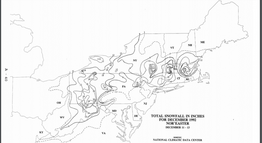
-
Dec 5/6th major coastal/ west Atlantic cyclogenesis ...?
klw replied to Typhoon Tip's topic in New England
That was my first winter in VT. It was a forecast of 12- 18+ for my area. I spent 3 days watching CNN covering the storm while we were pounded by nothing but virga as the storm stopped a county away from me. One of my least favorite events ever. -
Dec 5/6th major coastal/ west Atlantic cyclogenesis ...?
klw replied to Typhoon Tip's topic in New England
Based on nothing but my gut and how the last couple of years of modeling and storms have been going (in my now feeble memory), I expect a bit more of a NW trend this afternoon. (leading to some good meltdowns) Things will then trend back a bit to the east after that but the storm will have a bit more on the west side up here than the clown maps show and a heavy band will set up from MReeve to PF and up to Alex and Phineas. Reeve and Freak will end up with 11 or so, Kev in Tolland will get his 8" and accompanying power outages, heaviest will be Monadnocks to Dendrite up to the Maine folks. I get 3 to 5. That is all a guess. -
Dec 5/6th major coastal/ west Atlantic cyclogenesis ...?
klw replied to Typhoon Tip's topic in New England
Chasing a snow storm in New England in a sports car- what could go wrong? Please tell us you at least have snow tires on. -
Dec 5/6th major coastal/ west Atlantic cyclogenesis ...?
klw replied to Typhoon Tip's topic in New England
Thanks https://www.spc.noaa.gov/obswx/winter/boxpns_dec23.txt ...Middlesex County... Ayer final 21.0 (8.0 between 1030am-1130am) Westford 300 PM 18.0 West Townsend 150 PM 16.5 Tyngsboro 220 PM 16.0 Hopkinton 400 PM 15.5 Acton 125 PM 15.0 Chelmsford 1240 PM 15.0 (6.0 between 11am-1230pm) Littleton 1240 PM 15.0 Townsend 1210 PM 13.5 North Woburn 155 PM 10.7 Lexington 300 PM 10.5 Dracut 130 PM 10.0 Natick 1235 PM 9.5 Woburn Ctr. 145 PM 9.0 Acton 1120 AM 9.0 North Woburn 1240 PM 8.5 Waltham 1150 AM 6.0 Hillsborough County... Nashua 400 PM 19.5 Amherst 305 PM 17.5 Bedford 400 PM 14.0 Hollis 1150 AM 10.0 -
Dec 5/6th major coastal/ west Atlantic cyclogenesis ...?
klw replied to Typhoon Tip's topic in New England
The potential huge difference from the Upper Valley to S NH reminds me of a storm in the 98 to 01 time frame. My memory is that it ended on the 23rd because my parents were driving up for Christmas. We had very little in VT but I had to go to court in Manchester NH for a hearing first thing in the morning. When I got there it was snowing 4+ inches an hour and the city was a ghost town. The federal courthouse was closed and the roads in the middle of the city all had 6+ inches on them so I went to the Mall of NH to ride it out. 90 minutes and 6 more inches later the snow stopped. Manchester got 17". Does anyone remember this storm and know the year? Is it an analog for this? -
Dec 5/6th major coastal/ west Atlantic cyclogenesis ...?
klw replied to Typhoon Tip's topic in New England
Until tomorrow's trends to the west. -
Dec 5/6th major coastal/ west Atlantic cyclogenesis ...?
klw replied to Typhoon Tip's topic in New England
On the plus side, if today's 12 Z NAM verifies instead of yesterday's. I don't have to spend all dat Sunday shoveling. -
Watching it sleet and rain as we were living in RI until August of that year.
-
I know it is odd but in 20ish seasons, VT I have never gotten a storm give me over 20 inches. In this house 4 years, we have topped out at 19 inches. Granted that was within 4 days of another 18 inch storm. In Peacham for 7 seasons but we never topped 18 inches and we were prone to occasional shadowing from the Whites. Sure a couple of times I had measurable snow for 15+ straight days but most of the time it was snow globe events that only added up due to their frequency. Biggest storms I have been in topped out about 22 or 23 inches in CNJ in 83 and 96. I didn't keep records from when I lived in C VT from 92 to 02 but my memory does not have me topping 20 inches. In 3/93 for instance, we got 17" . With the NAM, it has me at 13'" at 84 hrs but cranking and the downstream numbers would indicate that we would get much more in the 12 hours after. It is moot but, yeah, I don't think I have ever topped 23 inches. Most winters, however, a SREF plume will give me 40+ at some point- if only.


